File:Satellite image of Madagascar in September 2003.jpg
跳至導覽
跳至搜尋
預覽大小:312 × 598 像素。 其他解析度:125 × 240 像素 | 250 × 480 像素 | 400 × 768 像素 | 534 × 1,024 像素 | 1,068 × 2,048 像素 | 3,214 × 6,164 像素。
原始檔案 (3,214 × 6,164 像素,檔案大小:2.94 MB,MIME 類型:image/jpeg)
說明
說明
添加單行說明來描述出檔案所代表的內容
| 描述 |
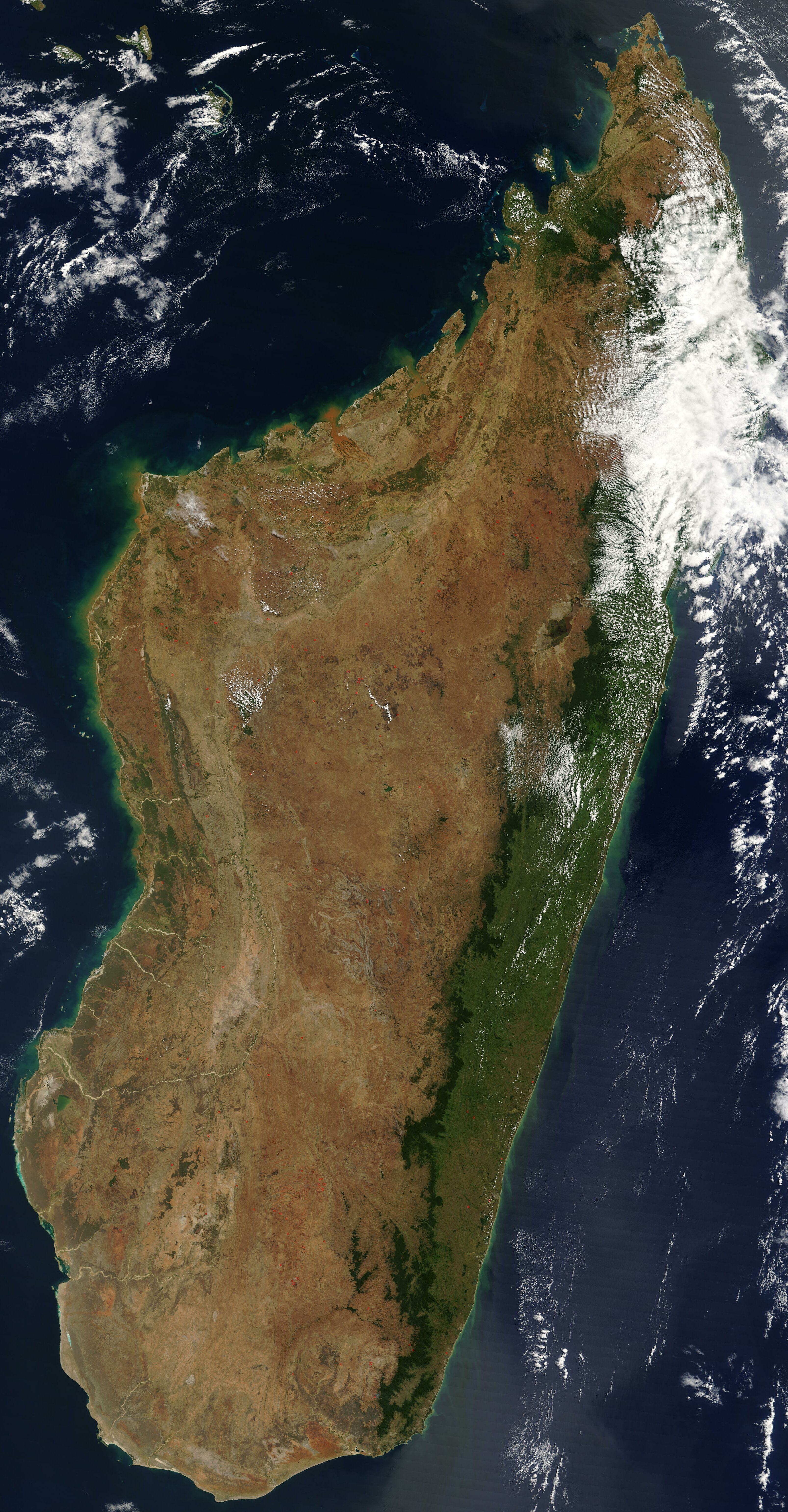
English: Satellite image of Madagascar in September 2003. Slightly cropped, original taken from NASA's Visible Earth: [1]. Original description:
|
| 日期 | |
| 來源 | http://visibleearth.nasa.gov/view_rec.php?id=5769 |
| 作者 | 未知 |
This image was selected as picture of the day on Wikimedia Commons for 1 November 2005. It was captioned as follows: English: Satellite image of Madagascar in September Other languages:
Čeština: Pohled ze satelitu na Madagaskar (září 2003) Cymraeg: Delwedd lloeren o Madagascar (Medi 2003) Deutsch: Satellitenbild von Madagaskar English: Satellite image of Madagascar in September Español: Imagen satelital de Madagascar en septiembre Français : Image satellite de Madagascar (septembre 2003) Gaeilge: Radharc Madagascar ó spás. Italiano: Immagine satellitare dell'isola di Madagascar Latina: Madagascariae imago satellitia Nederlands: Sattellietfoto van Madagaskar in september. Norsk bokmål: Satellittbilde av Madagaskar. Norsk nynorsk: Satellittbilde av Madagaskar. Polski: Satelitarny obraz Madagaskaru (wrzesień 2003) Slovenčina: Satelitná snímka Madagaskaru (spetember 2003) Suomi: Syyskuinen Madagaskar satelliittikuvassa Svenska: Satellitbild av Madagaskar. Русский: Спутниковая фотография Мадагаскара, четвёртого по величине острова в мире, сделанная 10 сентября 2003 года. ไทย: ภาพถ่ายดาวเทียมเกาะมาดากัสการ์เมื่อเดือนกันยายน พ.ศ. ๒๕๔๖ 中文: 2003年9月马达加斯加的卫星照片 |
| 本作品由NASA創作,屬於公有領域。根據NASA的版權政策:“NASA的創作除非另有聲明否則不受版權保護。”(參見:Template:PD-USGov/zh,NASA版權政策或JPL圖像使用政策) | ||
 |
警告:
|
檔案歷史
點選日期/時間以檢視該時間的檔案版本。
| 日期/時間 | 縮圖 | 尺寸 | 用戶 | 備註 | |
|---|---|---|---|---|---|
| 目前 | 2005年1月7日 (五) 12:51 | | 3,214 × 6,164(2.94 MB) | Hautala(對話 | 貢獻) | {{PD-USGov-NASA}} Satellite image of Madagascar in September 2003. Slightly cropped, original taken from NASA's Visible Earth http://visibleearth.nasa.gov/cgi-bin/viewrecord?25841 . Original description: The world’s fourth largest island, Madagasca |
無法覆蓋此檔案。
檔案用途
下列35個頁面有用到此檔案:
- Atlas of Madagascar
- Madagasikara / Madagascar
- Maps of Madagascar
- Commons:Potd/2005-11 (fr)
- Commons:Potd/2005-11 (pl)
- Commons:Potd/2005-11 (pt)
- Commons:Potd/2005-11 (ru)
- Commons:Potd/2005-11 (sv)
- Commons:Potd/2005-11 (tr)
- File:Andasibe National Park, Madagascar (4027581120).jpg
- Template:Potd/2005-11
- Template:Potd/2005-11-01
- Template:Potd/2005-11-01 (cs)
- Template:Potd/2005-11-01 (cy)
- Template:Potd/2005-11-01 (de)
- Template:Potd/2005-11-01 (en)
- Template:Potd/2005-11-01 (es)
- Template:Potd/2005-11-01 (fi)
- Template:Potd/2005-11-01 (fr)
- Template:Potd/2005-11-01 (ga)
- Template:Potd/2005-11-01 (gl)
- Template:Potd/2005-11-01 (it)
- Template:Potd/2005-11-01 (ja)
- Template:Potd/2005-11-01 (la)
- Template:Potd/2005-11-01 (nb)
- Template:Potd/2005-11-01 (nl)
- Template:Potd/2005-11-01 (nn)
- Template:Potd/2005-11-01 (pl)
- Template:Potd/2005-11-01 (pt)
- Template:Potd/2005-11-01 (ru)
- Template:Potd/2005-11-01 (sk)
- Template:Potd/2005-11-01 (sv)
- Template:Potd/2005-11-01 (th)
- Template:Potd/2005-11-01 (zh-hans)
- Category:Madagascar
.jpg)
全域檔案使用狀況
以下其他 wiki 使用了這個檔案:
- af.wikipedia.org 的使用狀況
- arz.wikipedia.org 的使用狀況
- ast.wikipedia.org 的使用狀況
- az.wikipedia.org 的使用狀況
- ba.wikipedia.org 的使用狀況
- be-tarask.wikipedia.org 的使用狀況
- br.wikipedia.org 的使用狀況
- ca.wikipedia.org 的使用狀況
- ce.wikipedia.org 的使用狀況
- ckb.wikipedia.org 的使用狀況
- cs.wikipedia.org 的使用狀況
- cv.wikipedia.org 的使用狀況
- dag.wikipedia.org 的使用狀況
- da.wikipedia.org 的使用狀況
- de.wikivoyage.org 的使用狀況
- diq.wikipedia.org 的使用狀況
- en.wikipedia.org 的使用狀況
- eo.wikipedia.org 的使用狀況
- eo.wikinews.org 的使用狀況
- eo.wiktionary.org 的使用狀況
- es.wikipedia.org 的使用狀況
- et.wikipedia.org 的使用狀況
- fa.wikipedia.org 的使用狀況
- fi.wikipedia.org 的使用狀況
- fi.wiktionary.org 的使用狀況
- fr.wikipedia.org 的使用狀況
- fr.wikivoyage.org 的使用狀況
- ga.wikipedia.org 的使用狀況
- gl.wikipedia.org 的使用狀況
- gpe.wikipedia.org 的使用狀況
- ha.wikipedia.org 的使用狀況
- he.wikipedia.org 的使用狀況
- ht.wikipedia.org 的使用狀況
- hy.wikipedia.org 的使用狀況
- ia.wikipedia.org 的使用狀況
檢視此檔案的更多全域使用狀況。