File:Satellite image of the Grand Canyon.jpeg
原始文件 (1,219 × 947像素,文件大小:299 KB,MIME类型:image/jpeg)
说明
说明
摘要
[编辑]
| 描述 |
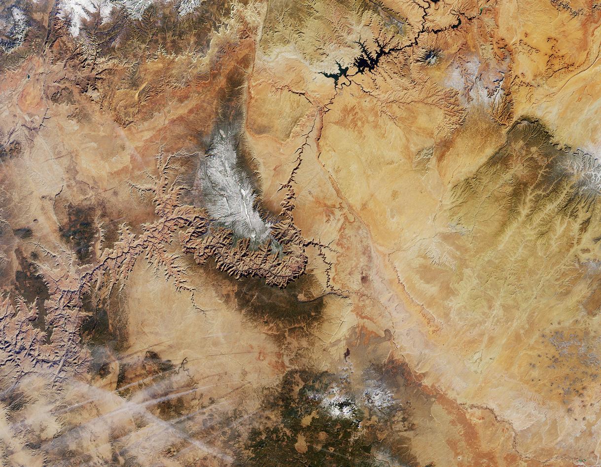
English: A satellite image of the Grand Canyon.
Northern Arizona and the Grand Canyon are captured in this pair of Multi-angle Imaging Spectroradiometer (MISR) images from December 31, 2000. The above image is a true color view from the nadir (vertical) camera. A stereo composite image was generated using data from MISR's vertical and 46-degree-forward cameras. Viewing the stereo image in 3-D requires the use of red/blue glasses with the red filter placed over your left eye. To facilitate stereo viewing, the images have been oriented with north at the left. In addition to the Grand Canyon itself, which is visible in the western (lower) half of the images, other landmarks include Lake Powell, on the left, and Humphreys Peak and Sunset Crater National Monument on the right. Meteor Crater appears as a small dark depression with a brighter rim, and is just visible along the upper right-hand edge. Can you find it? (NOTE: The image in this wiki has been rotated relative to the one on the NASA site, so the preceding description's references to "left", etc., are incorrect.) |
| 日期 | 未知日期 |
| 来源 | http://earthobservatory.nasa.gov/Newsroom/NewImages/Images/PIA03402_rgb.jpg linked from http://earthobservatory.nasa.gov/Newsroom/NewImages/images.php3?img_id=4808 |
| 作者 | NASA/GSFC/LaRC/JPL, MISR Team |
许可协议
[编辑]
| 本文件完全由NASA创作,在美国属于公有领域。根据NASA的版权方针,NASA的材料除非另有声明否则不受版权保护。(参见Template:PD-USGov/zh、NASA版权方针页面或JPL图片使用方针。) | ||
 |
警告:
|
文件历史
点击某个日期/时间查看对应时刻的文件。
| 日期/时间 | 缩略图 | 大小 | 用户 | 备注 | |
|---|---|---|---|---|---|
| 当前 | 2005年12月20日 (二) 00:06 | | 1,219 × 947(299 KB) | Carnildo(留言 | 贡献) | Rotated image 90 degrees so north is up |
| 2005年10月27日 (四) 05:33 |  | 947 × 1,219(914 KB) | Ævar Arnfjörð Bjarmason(留言 | 贡献) | A satellite image of the Grand Canyon. == Original caption == Northern Arizona and the Grand Canyon are captured in this pair of Multi-angle Imaging Spectroradiometer (MISR) images from December 31, 2000. The above image is a t |
您不可以覆盖此文件。
文件用途
没有页面使用本文件。
全域文件用途
以下其他wiki使用此文件:
- cs.wikipedia.org上的用途
- zh.wikipedia.org上的用途