File:Saxony locator map (1000).svg
Μετάβαση στην πλοήγηση
Πήδηση στην αναζήτηση

Το μέγεθος αυτής της PNG προεπισκόπησης αυτού του SVG το αρχείο: 686 × 600 εικονοστοιχεία. Άλλες αναλύσεις: 275 × 240 εικονοστοιχεία | 549 × 480 εικονοστοιχεία | 878 × 768 εικονοστοιχεία | 1.171 × 1.024 εικονοστοιχεία | 2.342 × 2.048 εικονοστοιχεία | 4.431 × 3.875 εικονοστοιχεία.
Πρωτότυπο αρχείο (Αρχείο SVG, ονομαστικό μέγεθος 4.431 × 3.875 εικονοστοιχεία, μέγεθος αρχείου: 4,7 MB)
Λεζάντες
Λεζάντες
Δεν ορίστηκε λεζάντα
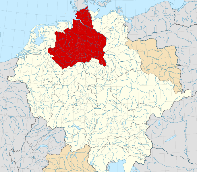
A map of the Duchy of Saxony (1000 CE).
Σύνοψη[επεξεργασία]
Αυτή η διανυσματική εικόνα δημιουργήθηκε με Inkscape .
| Περιγραφή |
English: A map of the Duchy of Saxony (German: Herzogtum Sachsen) around 1000 CE.
The map is derived from a vectorised version of one found in Professor G. Droysens Allgemeiner Historischer Handatlas, which was published in 1886 by R. Andrée Plate, and is now in the public domain. Note that while it uses the same scheme as standard location/locator maps, this map technically does not conform to the standard, as it is not in equirectangular projection. Therefore grid lines for latitude and longitude are also included on the sub-map. |
| Ημερομηνία | |
| Πηγή |
File: own work Data: File:Droysens-22-23.jpg |
| Δημιουργός | Alphathon /ˈæɫfə.θɒn/ (talk) |
| άλλες εκδόσεις |
|
.svg)
.svg)
.svg)
.svg)

.svg)
.svg)
.svg&action=edit§ion=1)
Αδειοδότηση[επεξεργασία]
.svg&action=edit§ion=2)
Το αρχείο διανέμεται υπό την άδεια Creative Commons Αναφορά προέλευσης-Παρόμοια διανομή 4.0 Διεθνής
- Είστε ελεύθερος:
- να μοιραστείτε – να αντιγράψετε, διανέμετε και να μεταδώσετε το έργο
- να διασκευάσετε – να τροποποιήσετε το έργο
- Υπό τις ακόλουθες προϋποθέσεις:
- αναφορά προέλευσης – Θα πρέπει να κάνετε κατάλληλη αναφορά, να παρέχετε σύνδεσμο για την άδεια και να επισημάνετε εάν έγιναν αλλαγές. Μπορείτε να το κάνετε με οποιοδήποτε αιτιολογήσιμο λόγο, χωρίς όμως να εννοείται με οποιονδήποτε τρόπο ότι εγκρίνουν εσάς ή τη χρήση του έργου από εσάς.
- παρόμοια διανομή – Εάν αλλάξετε, τροποποιήσετε ή δημιουργήσετε πάνω στο έργο αυτό, μπορείτε να διανείμετε αυτό που θα προκύψει μόνο υπό τους όρους της ίδιας ή συμβατής άδειας με το πρωτότυπο.
Ιστορικό αρχείου
Πατήστε σε μια ημερομηνία/ώρα για να δείτε το αρχείο όπως εμφανιζόταν εκείνη την χρονική στιγμή.
| Ημερομηνία/Ώρα | Μικρογραφία | Διαστάσεις | Χρήστης | Σχόλιο | |
|---|---|---|---|---|---|
| τρέχον | 16:15, 22 Μαΐου 2016 | | 4.431 × 3.875 (4,7 MB) | Alphathon (συζήτηση | Συνεισφορά) | Changed colour of the Kingdom of Italy to reflect its inclusion in the Holy Roman Empire. Changed the colour of Silesian tributaries so as the not imply it was part of the Kingdom. Also changed colour of Rügen since it was neither in the Empire nor th... |
| 02:26, 18 Μαΐου 2016 |  | 4.431 × 3.875 (4,7 MB) | Alphathon (συζήτηση | Συνεισφορά) | == {{int:filedesc}} == {{Inkscape}} {{Information |Description={{en|A map of the en:Duchy of Saxony (German: ''Herzogtum Sachsen'') around 1000 CE. The map is derived from a vectorised version of one found in Professor G. Droysens Allgem... |
Δεν μπορείτε να αντικαταστήσετε αυτό το αρχείο.
Χρήση αρχείου
Οι ακόλουθες 18 σελίδες χρησιμοποιούν προς αυτό το αρχείο:
- File:Angaria locator map (1000).svg
- File:Austria locator map (1000).svg
- File:Bavaria locator map (1000).svg
- File:Billung March locator map (1004).svg
- File:Deutschland um das Jahr 1000.svg
- File:Duchy of Swabia locator map (1004).svg
- File:March of Carniola locator map (1000).svg
- File:March of Lusatia locator map (1004).svg
- File:March of Meissen locator map (1004).svg
- File:March of Merseburg locator map (1004).svg
- File:March of Zeitz locator map (1004).svg
- File:Mark an der Sann locator map (1000).svg
- File:Nordalbingia locator map (1000).svg
- File:Nordgau locator map (1000).svg
- File:Northern March locator map (1004).svg
- File:Ostfalia locator map (1000).svg
- File:Westfalia locator map (1000).svg
- File:Zistanesfeld locator map (1000).svg
.svg)
.svg)
.svg)
.svg)
.svg)
.svg)
.svg)
.svg)
.svg)
.svg)
.svg)
Καθολική χρήση αρχείου
Τα ακόλουθα άλλα wiki χρησιμοποιούν αυτό το αρχείο:
- Χρήση σε ar.wikipedia.org
- Χρήση σε ast.wikipedia.org
- Χρήση σε azb.wikipedia.org
- Χρήση σε be.wikipedia.org
- Χρήση σε bg.wikipedia.org
- Χρήση σε ca.wikipedia.org
- Χρήση σε cs.wikipedia.org
- Χρήση σε de.wikipedia.org
- Χρήση σε el.wikipedia.org
- Χρήση σε en.wikipedia.org
- Χρήση σε es.wikipedia.org
- Χρήση σε et.wikipedia.org
- Χρήση σε fa.wikipedia.org
- Χρήση σε fr.wikipedia.org
- Χρήση σε fy.wikipedia.org
- Χρήση σε ga.wikipedia.org
- Χρήση σε it.wikipedia.org
- Χρήση σε ja.wikipedia.org
- Χρήση σε ko.wikipedia.org
- Χρήση σε mk.wikipedia.org
- Χρήση σε pl.wikipedia.org
- Χρήση σε pl.wiktionary.org
- Χρήση σε th.wikipedia.org
- Χρήση σε tr.wikipedia.org
- Χρήση σε vi.wikipedia.org
- Χρήση σε www.wikidata.org
- Χρήση σε zh.wikipedia.org
Μεταδεδομένα
.svg&oldid=748410812)
Κατηγορίες:
- Maps of the Duchy of Saxony
- Maps of the history of Saxony-Anhalt
- Maps of the history of Lower Saxony
- Locator maps of territories of the Holy Roman Empire (1000)
- Locator maps of territories of the Kingdom of Germany
- SVG versions of maps from Allgemeiner Historischer Handatlas
- Maps of the history of North Rhine-Westphalia
- Saxons
- Eastphalia
- 1000s