File:Saxony locator map (1000).svg
跳转到导航
跳转到搜索

此SVG文件的PNG预览的大小:686 × 600像素。 其他分辨率:275 × 240像素 | 549 × 480像素 | 878 × 768像素 | 1,171 × 1,024像素 | 2,342 × 2,048像素 | 4,431 × 3,875像素。
原始文件 (SVG文件,尺寸为4,431 × 3,875像素,文件大小:4.7 MB)
说明
说明
添加一行文字以描述该文件所表现的内容
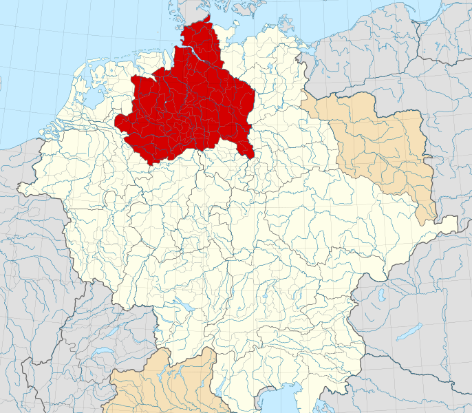
A map of the Duchy of Saxony (1000 CE).
摘要
[编辑]| 描述 |
English: A map of the Duchy of Saxony (German: Herzogtum Sachsen) around 1000 CE.
The map is derived from a vectorised version of one found in Professor G. Droysens Allgemeiner Historischer Handatlas, which was published in 1886 by R. Andrée Plate, and is now in the public domain. Note that while it uses the same scheme as standard location/locator maps, this map technically does not conform to the standard, as it is not in equirectangular projection. Therefore grid lines for latitude and longitude are also included on the sub-map. |
| 日期 | |
| 来源 |
File: own work Data: File:Droysens-22-23.jpg |
| 作者 | Alphathon /ˈæɫfə.θɒn/ (talk) |
| 其他版本 |
|
.svg)
.svg)
.svg)
.svg)

.svg)
.svg)
.svg&action=edit§ion=1)
许可协议
[编辑].svg&action=edit§ion=2)
本文件采用知识共享署名-相同方式共享 4.0 国际许可协议授权。
- 您可以自由地:
- 共享 – 复制、发行并传播本作品
- 修改 – 改编作品
- 惟须遵守下列条件:
- 署名 – 您必须对作品进行署名,提供授权条款的链接,并说明是否对原始内容进行了更改。您可以用任何合理的方式来署名,但不得以任何方式表明许可人认可您或您的使用。
- 相同方式共享 – 如果您再混合、转换或者基于本作品进行创作,您必须以与原先许可协议相同或相兼容的许可协议分发您贡献的作品。
文件历史
点击某个日期/时间查看对应时刻的文件。
| 日期/时间 | 缩略图 | 大小 | 用户 | 备注 | |
|---|---|---|---|---|---|
| 当前 | 2016年5月22日 (日) 16:15 | | 4,431 × 3,875(4.7 MB) | Alphathon(留言 | 贡献) | Changed colour of the Kingdom of Italy to reflect its inclusion in the Holy Roman Empire. Changed the colour of Silesian tributaries so as the not imply it was part of the Kingdom. Also changed colour of Rügen since it was neither in the Empire nor th... |
| 2016年5月18日 (三) 02:26 |  | 4,431 × 3,875(4.7 MB) | Alphathon(留言 | 贡献) | == {{int:filedesc}} == {{Inkscape}} {{Information |Description={{en|A map of the en:Duchy of Saxony (German: ''Herzogtum Sachsen'') around 1000 CE. The map is derived from a vectorised version of one found in Professor G. Droysens Allgem... |
您不可以覆盖此文件。
文件用途
以下18个页面使用本文件:
- File:Angaria locator map (1000).svg
- File:Austria locator map (1000).svg
- File:Bavaria locator map (1000).svg
- File:Billung March locator map (1004).svg
- File:Deutschland um das Jahr 1000.svg
- File:Duchy of Swabia locator map (1004).svg
- File:March of Carniola locator map (1000).svg
- File:March of Lusatia locator map (1004).svg
- File:March of Meissen locator map (1004).svg
- File:March of Merseburg locator map (1004).svg
- File:March of Zeitz locator map (1004).svg
- File:Mark an der Sann locator map (1000).svg
- File:Nordalbingia locator map (1000).svg
- File:Nordgau locator map (1000).svg
- File:Northern March locator map (1004).svg
- File:Ostfalia locator map (1000).svg
- File:Westfalia locator map (1000).svg
- File:Zistanesfeld locator map (1000).svg
.svg)
.svg)
.svg)
.svg)
.svg)
.svg)
.svg)
.svg)
.svg)
.svg)
.svg)
全域文件用途
以下其他wiki使用此文件:
- ar.wikipedia.org上的用途
- ast.wikipedia.org上的用途
- azb.wikipedia.org上的用途
- be.wikipedia.org上的用途
- bg.wikipedia.org上的用途
- ca.wikipedia.org上的用途
- cs.wikipedia.org上的用途
- de.wikipedia.org上的用途
- el.wikipedia.org上的用途
- en.wikipedia.org上的用途
- es.wikipedia.org上的用途
- et.wikipedia.org上的用途
- fa.wikipedia.org上的用途
- fr.wikipedia.org上的用途
- fy.wikipedia.org上的用途
- ga.wikipedia.org上的用途
- it.wikipedia.org上的用途
- ja.wikipedia.org上的用途
- ko.wikipedia.org上的用途
- mk.wikipedia.org上的用途
- pl.wikipedia.org上的用途
- pl.wiktionary.org上的用途
- th.wikipedia.org上的用途
- tr.wikipedia.org上的用途
- vi.wikipedia.org上的用途
- www.wikidata.org上的用途
- zh.wikipedia.org上的用途
元数据
.svg&oldid=748410812)
分类:
- Maps of the Duchy of Saxony
- Maps of the history of Saxony-Anhalt
- Maps of the history of Lower Saxony
- Locator maps of territories of the Holy Roman Empire (1000)
- Locator maps of territories of the Kingdom of Germany
- SVG versions of maps from Allgemeiner Historischer Handatlas
- Maps of the history of North Rhine-Westphalia
- Saxons
- Eastphalia
- 1000s