File:Schleswig-Holstein map.PNG
跳至導覽
跳至搜尋
預覽大小:389 × 600 像素。 其他解析度:156 × 240 像素 | 311 × 480 像素 | 763 × 1,176 像素。
原始檔案 (763 × 1,176 像素,檔案大小:131 KB,MIME 類型:image/png)
說明
說明
添加單行說明來描述出檔案所代表的內容
| 描述 |
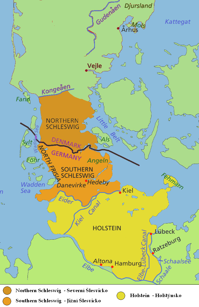
English: Map of Jutland Peninsula
Southern Jutland (Sønderjylland in Danish) or Northern Schleswig (Nordschleswig in German): Danish since 1920; part of the Duchy of Schleswig until 1864; German from 1864 until 1920
Southern Schleswig (German since 1864; part of the Duchy of Schleswig until 1864; formerly considered part of Southern Jutland)
Historical area of Holstein, sometimes considered part of Jutland Peninsula - south to the Elbe and the Elbe-Lübeck Canal
Deutsch: Karte der Halbinsel Jütland/Cimbrische Halbinsel
Nordschleswig, dänisch Sønderjylland (Südjütland): Herzogtum Schleswig bis 1864, Deutschland 1864 bis 1920, Dänemark seit 1920
Südschleswig (bis 1920 als Teil Südjütlands betrachtet): Herzogtum Schleswig bis 1864, Deutschland seit 1864
Historisches Gebiet von Holstein, manchmal als Teil der Halbinsel Jütland angesehen - südlich bis zur Elbe und dem Elbe-Lübeck-Kanal
Čeština: Mapa Jutského poloostrova
Jižní Jutsko, Severní Schleswig (Sønderjylland, Nordslesvig)
Jižní Schleswig
Historický Holstein |
| 日期 | (UTC) |
| 來源 | |
| 作者 |
|
| 這是一張修飾過的圖片,即本圖片是用軟體修改過後的版本,修改的方式或內容有:map only of Schleswig-Hostein region, in english and czech。原版圖片來源:Jutland Peninsula map.PNG。修改者:Kolomaznik。
|
我,本作品的著作權持有者,決定用以下授權條款發佈本作品:
| 此檔案採用創用CC 姓名標示-相同方式分享 3.0 未在地化版本授權條款。 | ||
| ||
| 已新增授權條款標題至此檔案,作為GFDL授權更新的一部份。 |

|
已授權您依據自由軟體基金會發行的無固定段落、封面文字和封底文字GNU自由文件授權條款1.2版或任意後續版本,對本檔進行複製、傳播和/或修改。該協議的副本列在GNU自由文件授權條款中。 |
您可以選擇您需要的授權條款。
原始上傳日誌
[編輯]
This image is a derivative work of the following images:
- File:Jutland_Peninsula_map.PNG licensed with Cc-by-sa-2.5,2.0,1.0, Cc-by-sa-3.0-migrated, GFDL
- 2008-04-23T10:22:18Z PhJ 964x1741 (145790 Bytes) {{Information |Description= |Source= |Date= |Author= |Permission= |other_versions= }}
- 2006-05-04T07:46:11Z Roke 964x1741 (120421 Bytes) schaale schaalsee
- 2006-04-29T03:27:54Z Roke 964x1741 (118906 Bytes) Altona position
- 2006-04-29T03:21:29Z Roke 964x1741 (118899 Bytes) wadden sea, nordstrand border, extend yellow to Schalle and Ratzeburg, +Altona, +Helgoland
- 2006-04-27T00:20:44Z Roke 964x1741 (115442 Bytes) nordstrand
- 2006-04-27T00:15:11Z Roke 964x1741 (115380 Bytes) same colour from border to Eider river
- 2006-04-26T01:22:06Z Valentinian 964x1741 (137475 Bytes) Fixed Nordstrand
- 2006-04-25T12:45:35Z Roke 964x1741 (116408 Bytes) moved dannevirke north
- 2006-04-25T05:30:35Z Roke 964x1741 (116169 Bytes) deleted a layer i shouldnt have
- 2006-04-25T05:26:17Z Roke 964x1741 (114293 Bytes) minor fix of eider, kiel canal
- 2006-04-25T05:02:03Z Roke 964x1741 (116502 Bytes) eider, wadden sea, hedeby
- 2006-04-17T06:17:25Z Roke 964x1741 (116712 Bytes) Map of Jutland Peninsula [[Category:Denmark]]
Uploaded with derivativeFX
檔案歷史
點選日期/時間以檢視該時間的檔案版本。
| 日期/時間 | 縮圖 | 尺寸 | 使用者 | 備註 | |
|---|---|---|---|---|---|
| 目前 | 2009年8月2日 (日) 16:17 | | 763 × 1,176(131 KB) | Kolomaznik(留言 | 貢獻) | {{Information |Description= |Source=*File:Jutland_Peninsula_map.PNG |Date=2009-08-02 16:15 (UTC) |Author=*File:Jutland_Peninsula_map.PNG: Roke *derivative work: ~~~ |Permission=see below |other_versions= }} {{RetouchedPicture|map only of Sch |
無法覆蓋此檔案。
檔案用途
下列頁面有用到此檔案:
- File:Schleswig-Hostein map.PNG (檔案重新導向)
全域檔案使用狀況
以下其他 wiki 使用了這個檔案:
- ca.wikipedia.org 的使用狀況
- cs.wikipedia.org 的使用狀況
- fi.wikipedia.org 的使用狀況
- fr.wiktionary.org 的使用狀況
- ja.wikipedia.org 的使用狀況
- zh.wikipedia.org 的使用狀況