File:Scythian capital and royal kurgans.png
Aller à la navigation
Aller à la recherche
Pas de plus haute résolution disponible.
Scythian_capital_and_royal_kurgans.png (489 × 424 pixels, taille du fichier : 23 kio, type MIME : image/png)
Légendes
Légendes
Ajoutez en une ligne la description de ce que représente ce fichier
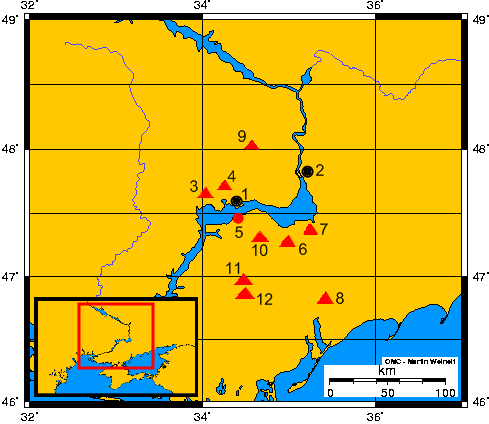
- Opis mapy - Description of the map:
- 1) Nikopol (współczesne miasto/modern town)
- 2) Zaporoże (współczesne miasto) - Zaporizhia (modern town)
- 3) Tołstaja Mogiła (kurhan) - Towstaya Mogila (kurgan)
- 4) Czertomłyk (kurhan) - Chertomlyk (kurgan)
- 5) Grodzisko Kamienskoje – Kamienskoye settlement
- 6) Sołocha (kurhan) – Solokha (kurgan)
- 7) Gajmanowa Mogiła (kurhan) - Gaymanova Mogila
- 8) Kurhan Melitopolski - Melitopol's kurgan
- 9) Kurhan Aleksandropolski - Alexandropol's kurgan
- 10) Bolszaja Cymbałka (kurhan) - Bolshaya Tsymbalka (kurgan)
- 11) Kozieł (kurhan) - Kozel (kurgan)
- 12) Oguz (kurhan) - Oguz (kurgan)
- 1) Nikopol (współczesne miasto/modern town)
| Description |
English: Ancient scythian town-capital Kamienskoje and so-called royal scytians kurgans on grounds of the Lower Dnieper
Español: La antigua ciudad – capital Kamienskoie y así llamados real kurganos de escitas al curso bajo del Río Dniéper
Polski: Starożytne miasto–stolica Kamienskoje i tzw. królewskie kurhany scytyjskie nad dolnym Dnieprem
Русский: Каменское городище-столица Скифии и так называемые царские курганы Скифии в нижнем течении Днепра |
||
| Date | 10-12.11.2007 | ||
| Source | Travail personnel; on the basis of maps from historical books and WWW | ||
| Auteur | Janmad | ||
| Autorisation (Réutilisation de ce fichier) |
Moi, en tant que détenteur des droits d’auteur sur cette œuvre, je la publie sous les licences suivantes :
Ce fichier est disponible selon les termes de la licence Creative Commons Attribution 3.0 Non transposée.
Vous pouvez choisir l’une de ces licences. |

Historique du fichier
Cliquer sur une date et heure pour voir le fichier tel qu'il était à ce moment-là.
| Date et heure | Vignette | Dimensions | Utilisateur | Commentaire | |
|---|---|---|---|---|---|
| actuel | 12 novembre 2007 à 16:29 | | 489 × 424 (23 kio) | Janmad (d | contributions) | *Opis mapy-Description of the map:<br> **1)Nikopol (<br> **2)Zaporoże - Zaporizhia<br> **3)Tołstaja Mogiła (kurhan) - Towstaya Mogila (kurgan)<br> **4)Czertomłyk (kurhan) - Chertomlyk (kurgan)<br> **5)Grodzisko Kamienskoje – Kamienskoye settlement<b |
Vous ne pouvez pas remplacer ce fichier.
Utilisations locales du fichier
Aucune page n’utilise ce fichier.
Utilisations du fichier sur d’autres wikis
Les autres wikis suivants utilisent ce fichier :
- Utilisation sur be.wikipedia.org
- Utilisation sur de.wikipedia.org
- Utilisation sur en.wikipedia.org
- Utilisation sur es.wikipedia.org
- Utilisation sur fi.wikipedia.org
- Utilisation sur fr.wikipedia.org
- Utilisation sur pl.wikipedia.org
- Utilisation sur ru.wikipedia.org
- Utilisation sur uk.wikipedia.org
- Utilisation sur www.wikidata.org