File:Second world war asia 1937-1942 map en6.png
跳至導覽
跳至搜尋
預覽大小:780 × 600 像素。 其他解析度:312 × 240 像素 | 624 × 480 像素 | 999 × 768 像素 | 1,298 × 998 像素。
原始檔案 (1,298 × 998 像素,檔案大小:250 KB,MIME 類型:image/png)
說明
說明
添加單行說明來描述出檔案所代表的內容
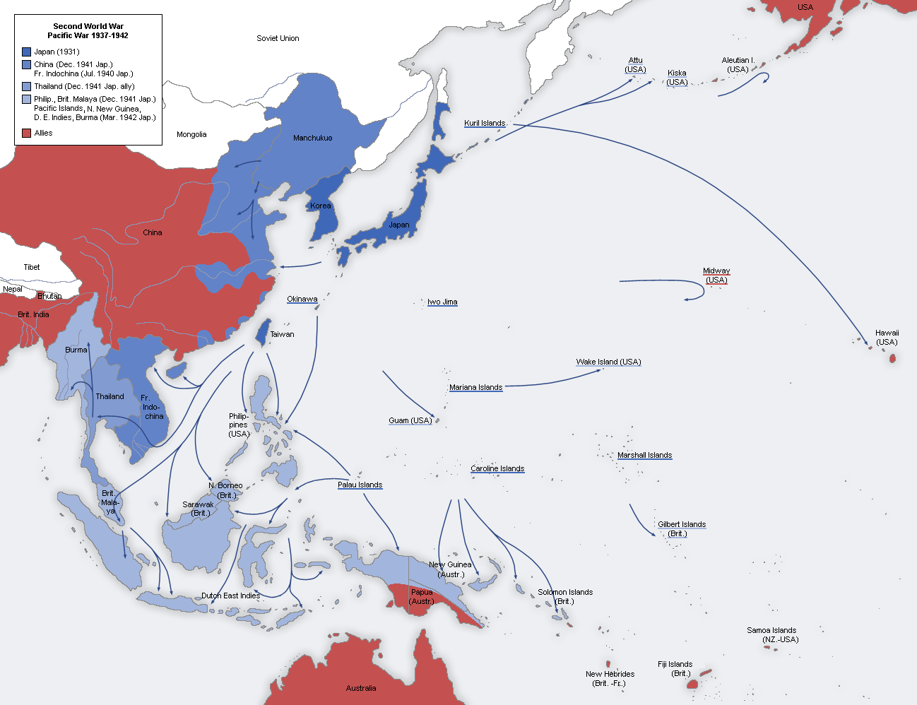
Map of The Japanese Empire at its Peak.
摘要
[編輯]
| 描述 |
English: A map of the Japanese advance from 1937 to 1942. 日本語: 日本による占領地域の拡大(1937年から1942年) |
| 日期 |
Original Image: 22 August 2005 Derivative Image: 31 July 2011 |
| 來源 |
本檔案衍生自: Second world war asia 1937-1942 map de.png |
| 作者 |
Original Author: User:San Jose Derivative Author: Dead Mary |
| 授權許可 (重用此檔案) |
This image is a translation of the original, created and released under the terms of the GNU Free Documentation License. |
授權條款
[編輯]

|
已授權您依據自由軟體基金會發行的無固定段落、封面文字和封底文字GNU自由文件授權條款1.2版或任意後續版本,對本檔進行複製、傳播和/或修改。該協議的副本列在GNU自由文件授權條款中。 |
| 此檔案採用創用CC 姓名標示-相同方式分享 3.0 未在地化版本授權條款。 | ||
| ||
| 已新增授權條款標題至此檔案,作為GFDL授權更新的一部份。 |
檔案歷史
點選日期/時間以檢視該時間的檔案版本。
| 日期/時間 | 縮圖 | 尺寸 | 使用者 | 備註 | |
|---|---|---|---|---|---|
| 目前 | 2022年2月13日 (日) 19:55 | | 1,298 × 998(250 KB) | Rzzgn(留言 | 貢獻) | second_world_war_asia_1937-1942_map.png |
| 2021年4月17日 (六) 14:57 |  | 1,298 × 998(250 KB) | Rzzgn(留言 | 貢獻) | Although Manchuria was a puppet state, it was never a part of the Japanese Empire. | |
| 2020年7月14日 (二) 18:59 |  | 1,298 × 998(197 KB) | FDRMRZUSA(留言 | 貢獻) | Reverted to version as of 20:16, 6 May 2017 (UTC): Manchukuo was part of the Japanese empire before 1936. | |
| 2019年1月8日 (二) 07:47 |  | 1,298 × 998(250 KB) | Rzzgn(留言 | 貢獻) | the colour of Manchukuo | |
| 2017年5月6日 (六) 20:16 |  | 1,298 × 998(197 KB) | Dr.Koo(留言 | 貢獻) | Reverted to version as of 22:01, 11 July 2014 (UTC) use the same color scheme as in other language versions. | |
| 2017年5月6日 (六) 20:15 |  | 1,298 × 998(219 KB) | Dr.Koo(留言 | 貢獻) | Reverted to version as of 22:01, 11 July 2014 (UTC) use the same color scheme as in other language versions. | |
| 2014年7月18日 (五) 17:26 |  | 1,298 × 998(220 KB) | Hohum(留言 | 貢獻) | More natural colours - water blue, etc. | |
| 2014年7月11日 (五) 22:01 |  | 1,298 × 998(219 KB) | Renamed user df2u53fvwn(留言 | 貢獻) | Tibet didn't officially independent | |
| 2011年7月30日 (六) 22:59 |  | 1,298 × 998(197 KB) | Dead Mary(留言 | 貢獻) |
無法覆蓋此檔案。
檔案用途
下列6個頁面有用到此檔案:
全域檔案使用狀況
以下其他 wiki 使用了這個檔案:
- azb.wikipedia.org 的使用狀況
- bg.wikipedia.org 的使用狀況
- br.wikipedia.org 的使用狀況
- en.wikipedia.org 的使用狀況
- World War II
- Military history of Japan
- Empire of Japan
- Shōwa era
- Nanshin-ron
- Burma campaign (1942–1943)
- Key events of the 20th century
- Arakan campaign (1942–1943)
- Talk:Japan/Archive 19
- User:JacksonKo/ideology
- Kantokuen
- Japan during World War II
- Presidency of Franklin D. Roosevelt, third and fourth terms
- Foreign policy of the Franklin D. Roosevelt administration
- User:Paul Siebert/sandbox
- User:Shafin10555/sandbox
- Mont Tremblant Conference
- User:Hmmmmm maybe/sandbox
- Draft:World War II (Draft)
- es.wikipedia.org 的使用狀況
- fa.wikipedia.org 的使用狀況
- fi.wikipedia.org 的使用狀況
- fo.wikipedia.org 的使用狀況
- fr.wikipedia.org 的使用狀況
- gl.wikipedia.org 的使用狀況
- he.wikipedia.org 的使用狀況
- hy.wikipedia.org 的使用狀況
- id.wikipedia.org 的使用狀況
- it.wikipedia.org 的使用狀況
- ja.wikipedia.org 的使用狀況
- ja.wikibooks.org 的使用狀況
- ka.wikipedia.org 的使用狀況
- km.wikipedia.org 的使用狀況
- ko.wikipedia.org 的使用狀況
- lv.wikipedia.org 的使用狀況
- mk.wikipedia.org 的使用狀況
- ms.wikipedia.org 的使用狀況
- nl.wikipedia.org 的使用狀況
- pnb.wikipedia.org 的使用狀況
- pt.wikipedia.org 的使用狀況
檢視此檔案的更多全域使用狀況。