File:Semresrr.jpg
Aller à la navigation
Aller à la recherche
Taille de cet aperçu : 422 × 599 pixels. Autres résolutions : 169 × 240 pixels | 545 × 774 pixels.
Fichier d’origine (545 × 774 pixels, taille du fichier : 122 kio, type MIME : image/jpeg)
Légendes
Légendes
Ajoutez en une ligne la description de ce que représente ce fichier
Description
[modifier]
| Description |
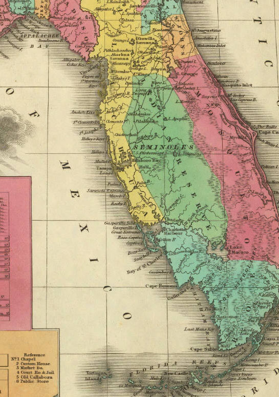
English: Reservation land of the Seminoles in the 1820s and 1830s. Published in 1831 by A. Finley Philadelphia in A New General Atlas Comprising a Complete Set of Maps, representing the Grand Divisions Of The Globe. David Rumsey Map Collection.
Downloaded from http://www.johnhorse.com/trail/01/c/08.htm Originally published in 1831:
|
| Source | see above |
| Auteur | Anthony Finley |
Conditions d’utilisation
[modifier]
Ce document est dans le domaine public aux États-Unis. Ceci s'applique aux travaux des États-Unis où le copyright a expiré, souvent parce que sa première publication s'est produite avant le 1er janvier 1929. Voir cette page pour davantage d'explication.
|
 | |
 |
Cette image peut ne pas être dans le domaine public en dehors des États-Unis (ceci s'applique particulièrement au Canada, en Chine (pas Hong Kong, Macao, ni Taïwan), en Allemagne ou en Suisse). Le créateur et l'année de la publication sont l'information essentielle et doivent être fournis.
|
Journal des téléversements d’origine
[modifier]
La page de description originale était ici. Tous les noms d'utilisateur qui suivent se rapportent à en.wikipedia.
- 2006-10-21 18:04 Dalbury 229×325×8 (20506 bytes) Downloaded from http://www.johnhorse.com/trail/01/c/08.htm Published in 1831 by A. Finley Philadelphia in ''A New General Atlas Comprising a Complete Set of Maps, representing the Grand Divisions Of The Globe''.
Historique du fichier
Cliquer sur une date et heure pour voir le fichier tel qu'il était à ce moment-là.
| Date et heure | Vignette | Dimensions | Utilisateur | Commentaire | |
|---|---|---|---|---|---|
| actuel | 2 mars 2008 à 11:59 | | 545 × 774 (122 kio) | SalomonCeb (d | contributions) | Better version in http://www.johnhorse.com/trail/01/c/08zz.htm |
| 2 mars 2008 à 11:56 |  | 229 × 325 (20 kio) | SalomonCeb (d | contributions) | {{Information |Description={{en|Reservation land of the Seminoles in the 1820s and 1830s. Published in 1831 by A. Finley Philadelphia in A New General Atlas Comprising a Complete Set of Maps, representing the Grand Divisions Of The Globe. David Rumsey Ma |
Vous ne pouvez pas remplacer ce fichier.
Utilisations locales du fichier
Aucune page n’utilise ce fichier.
Utilisations du fichier sur d’autres wikis
Les autres wikis suivants utilisent ce fichier :
- Utilisation sur fr.wikipedia.org
- Utilisation sur hu.wikipedia.org
- Utilisation sur it.wikipedia.org