File:Serbia and Montenegro.svg
Pāriet uz navigāciju
Pāriet uz meklēšanu

Size of this PNG preview of this SVG file: 450 × 456 pikseļi. Citi izmēri: 237 × 240 pikseļi | 474 × 480 pikseļi | 758 × 768 pikseļi | 1 011 × 1 024 pikseļi | 2 021 × 2 048 pikseļi.
Sākotnējais fails (SVG fails, definētais izmērs 450 × 456 pikseļi, faila izmērs: 586 KB)
Captions
Captions
Pievieno vienas rindiņas aprakstu, ko šis fails attēlo
| Apraksts |
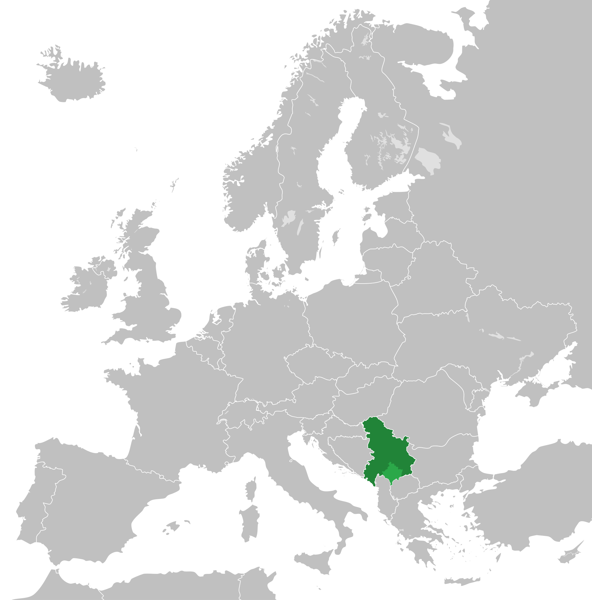
English: Map of the Federal Republic of Yugoslavia (1992-2003) and the State Union of Serbia and Montenegro (2003-2006).
Note: Following the adoption of Resolution 1244 on 10 June 1999, Kosovo was placed under a UN Interim Administration – de facto separating it from the rest of Yugoslavia. |
| Datums | |
| Avots | Own work, based upon File:Blank map of Europe.svg |
| Autors |
This W3C-unspecified vector image was created with Inkscape . |
| Atļauja: (Šī faila izmantošana citur) |
Šis fails tiek izplatīts saskaņā ar licences Creative Commons Atsauce-Līdzīgi Noteikumi 3.0 Vispārējiem noteikumiem.
|
Faila hronoloģija
Uzklikšķini uz datums/laiks kolonnā esošās saites, lai apskatītos, kā šis fails izskatījās tad.
| Datums/Laiks | Attēls | Izmēri | Dalībnieks | Komentārs | |
|---|---|---|---|---|---|
| tagadējais | 2020. gada 31. augusts, plkst. 01.48 | | 450 × 456 (586 KB) | Savasampion (diskusija | devums) | Kosovo fixed |
| 2019. gada 27. aprīlis, plkst. 18.31 |  | 450 × 456 (586 KB) | Illegitimate Barrister (diskusija | devums) | cleanup nodes | |
| 2018. gada 5. jūlijs, plkst. 05.05 |  | 450 × 456 (587 KB) | TRAJAN 117 (diskusija | devums) | +++ | |
| 2015. gada 2. maijs, plkst. 22.08 |  | 450 × 456 (584 KB) | TRAJAN 117 (diskusija | devums) | +++ | |
| 2013. gada 17. augusts, plkst. 13.15 |  | 680 × 520 (598 KB) | TRAJAN 117 (diskusija | devums) | Adjustment | |
| 2011. gada 13. decembris, plkst. 22.43 |  | 680 × 520 (654 KB) | TRAJAN 117 (diskusija | devums) | {{Information |Description ={{en|1=Map of Serbia and Montenegro, circa 2002.}} |Source =Own work, based upon [http://commons.wikimedia.org/wiki/File:Blank_map_of_Europe.svg] |Author =25px '''[[ |
Šo failu nevar pārrakstīt.
Faila lietojums
Šo failu izmanto šajās 22 lapās:
- User:J budissin/Uploads/BiH/2018 July 1-10
- User:J budissin/Uploads/BiH/2019 April 21-30
- Commons:Graphic Lab/Illustration workshop/Archive/2013
- Category:1995 in Yugoslavia
- Category:1996 in Yugoslavia
- Category:1997 in Yugoslavia
- Category:1998 in Yugoslavia
- Category:1999 in Yugoslavia
- Category:2002 in Yugoslavia
- Category:2003 in Serbia and Montenegro
- Category:2003 in Yugoslavia
- Category:2004 in Serbia and Montenegro
- Category:2005 in Serbia and Montenegro
- Category:2006 in Serbia and Montenegro
- Category:Culture of Serbia and Montenegro
- Category:Events in Serbia and Montenegro
- Category:Federal Republic of Yugoslavia
- Category:Maps of Serbia and Montenegro
- Category:Serbia and Montenegro
- Category:Serbia and Montenegro by year
- Category:Sports events in Serbia and Montenegro
- Category:Tennis players from Serbia and Montenegro
Globālais faila lietojums
Šīs Vikipēdijas izmanto šo failu:
- Izmantojums af.wikipedia.org
- Izmantojums ar.wikipedia.org
- Izmantojums arz.wikipedia.org
- Izmantojums ast.wikipedia.org
- Izmantojums azb.wikipedia.org
- Izmantojums az.wikipedia.org
- Izmantojums be-tarask.wikipedia.org
- Izmantojums bg.wikipedia.org
- Izmantojums bn.wikipedia.org
- Izmantojums ca.wikipedia.org
- Izmantojums cs.wikipedia.org
- Izmantojums de.wikipedia.org
- Izmantojums en.wikipedia.org
- Izmantojums en.wikinews.org
- Izmantojums eo.wikipedia.org
- Izmantojums es.wikipedia.org
- Izmantojums fa.wikipedia.org
- Izmantojums fi.wikipedia.org
- Izmantojums fr.wikipedia.org
- Izmantojums fr.wikinews.org
- Izmantojums ga.wikipedia.org
- Izmantojums gl.wikipedia.org
- Izmantojums he.wikipedia.org
- Izmantojums hr.wikipedia.org
- Izmantojums hy.wikipedia.org
- Izmantojums ia.wikipedia.org
- Izmantojums id.wikipedia.org
- Izmantojums incubator.wikimedia.org
- Izmantojums it.wikipedia.org
- Izmantojums ja.wikipedia.org
- Izmantojums kk.wikipedia.org
- Izmantojums ko.wikipedia.org
- Izmantojums lb.wikipedia.org
- Izmantojums li.wikipedia.org
Skatīt šī faila pilno globālo izmantojumu.