File:Serbia in the Yugoslav Wars.png
Fitxer original (1.285 × 892 píxels, mida del fitxer: 130 Ko, tipus MIME: image/png)
Llegendes
Llegendes

|
Aquesta imatge (de tipus military map) s'hauria de tornar a crear utilitzant gràfics vectorials com ara un fitxer SVG. Això té diversos avantatges; en trobareu més informació a Commons:Media for cleanup. Si ja disposeu d'una versió d'aquesta imatge en format SVG, us preguem que la pengeu; després, reemplaceu aquesta plantilla amb la plantilla {{Vector version available|nom nou de la imatge.svg}} en aquesta imatge.
|
Resum
[modifica]| Descripció |
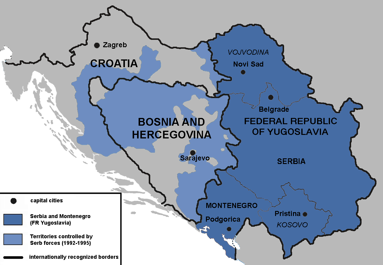
English: Territories of the Republic of Bosnia and Herzegovina and the Republic of Croatia controlled by the Serb forces, after the Operation Corridor (July 1992) in the Yugoslav Wars.
According to the prosecution of War Crimes Tribunal, "Serbian forces" included Yugoslav Army, Serb Territorial Defense of Bosnia and Herzegovina and Croatia, Republic of Srpska Krajina Army, Army of the Republika Srpska, territorial defense of Serbia and Montenegro, Police of Serbia and Police of Republika Srpska, including national security, special police forces of Krajina known as "Martićevci", as well as all Serbian paramilitary forces and volunteer units.[1] Croatia declared independence on June 25, 1991. It was internationally recognized on 15 January 1992 by the United Nations. Bosnia and Herzegovina declared independence on March 5 1992. It was internationally recognized on 22 May 1992 by the United Nations. Serbia and Montenegro proclaimed FR Yugoslavia as a sole successor state of SFR Yugoslavia, on April 27 1992. It remained unrecognized during the conflict (1991-1995). |
||
| Data | |||
| Font | Treball propi | ||
| Autor | Mladifilozof | ||
| Permís (Com reutilitzar aquest fitxer) |
Jo, el titular dels drets d'autor d'aquest treball, el public sota les següents llicències: Aquest fitxer està subjecte a la llicència de Creative Commons Reconeixement i Compartir Igual 3.0 No adaptada.
Podeu seleccionar la llicència que vulgueu. |
||
| Altres versions |
|


- ↑ Šešelj ICTY Case information sheet (retrieved 10.07.2009.)
Historial del fitxer
Cliqueu una data/hora per veure el fitxer tal com era aleshores.
| Data/hora | Miniatura | Dimensions | Usuari/a | Comentari | |
|---|---|---|---|---|---|
| actual | 16:09, 13 gen 2019 | | 1.285 × 892 (130 Ko) | Illegitimate Barrister (discussió | contribucions) | labelled FRoY |
| 23:50, 11 ago 2012 |  | 1.285 × 892 (106 Ko) | DIREKTOR (discussió | contribucions) | Small fix | |
| 00:14, 3 abr 2012 |  | 1.285 × 892 (76 Ko) | Phoenix B 1of3 (discussió | contribucions) | The blue map appears clearer and easier to understand | |
| 11:34, 2 abr 2012 |  | 1.285 × 892 (83 Ko) | Fezz5555 (discussió | contribucions) | Returning the original previous image of the author. | |
| 23:27, 10 des 2011 |  | 1.285 × 892 (76 Ko) | DIREKTOR (discussió | contribucions) | Colour | |
| 04:12, 22 feb 2010 |  | 1.285 × 892 (83 Ko) | Mladifilozof (discussió | contribucions) | improved | |
| 20:24, 16 feb 2010 |  | 1.285 × 892 (89 Ko) | Mladifilozof (discussió | contribucions) | {{Information |Description={{en|1=Territories of the Republic of Bosnia and Herzegovina and the Republic of Croatia controlled by the Serbian forces during the [[:en:Yugoslav Wars|Yugo |
No podeu sobreescriure aquest fitxer.
Ús del fitxer
Les 7 pàgines següents utilitzen aquest fitxer:
Ús global del fitxer
Utilització d'aquest fitxer en altres wikis:
- Utilització a ar.wikipedia.org
- Utilització a azb.wikipedia.org
- Utilització a az.wikipedia.org
- Utilització a be.wikipedia.org
- Utilització a bg.wikipedia.org
- Utilització a bs.wikipedia.org
- Utilització a ca.wikipedia.org
- Utilització a cs.wikipedia.org
- Utilització a da.wikipedia.org
- Utilització a de.wikipedia.org
- Utilització a el.wikipedia.org
- Utilització a en.wikipedia.org
- Siege of Sarajevo
- Greater Serbia
- Bosnian genocide
- Republika Srpska (1992–1995)
- Talk:Republika Srpska (1992–1995)
- Croatian War of Independence
- Talk:Joint criminal enterprise
- Talk:Republic of Bosnia and Herzegovina
- Talk:Bosnian War/Archive 3
- Serbia in the Yugoslav Wars
- Talk:Republic of Serbian Krajina/Archive 3
- Talk:Bosnian genocide/Archive 4
- Wikipedia:Graphics Lab/Map workshop/Archive/Oct 2011
- User:Phoenix B 1of3/Stop Greater Serbia
- Talk:Slobodan Milošević/Archive 2
- Talk:Siege of Sarajevo/Archive 1
- Agreement on Friendship and Cooperation between Bosnia and Herzegovina and Croatia
- Talk:Operation Corridor 92/Archive 1
- Proposed secession of Republika Srpska
- Talk:History of Serbia/Archive 1
- Talk:Republic of Serbia (1992–2006)/Archive 1
- Talk:Russia/Archive 16
- User:Falcaorib/Serbia, Yugoslavia and Albania
- Battles of Ilidža
- Utilització a es.wikipedia.org
- Utilització a eu.wikipedia.org
- Utilització a fr.wikipedia.org
- Utilització a gl.wikipedia.org
Vegeu més usos globals d'aquest fitxer.
Metadades
- Maps of Greater Serbia
- Maps of the history of Serbia in modern times
- Maps of the history of Montenegro in modern times
- Maps of the history of Republika Srpska
- Maps of the Republic of Serbian Krajina
- Maps of the history of Kosovo in modern times
- Maps of the history of Vojvodina
- Maps of the Yugoslav wars
- Maps of the Bosnian War
- Maps of the Croatian War of Independence
- Maps of the history of the modern Balkans
- Maps of Kosovo and Metohija
- Maps of Republika Srpska (1992-1995)