File:Sevastopol, Ukraine.jpg

原始文件 (1,080 × 1,440像素,文件大小:455 KB,MIME类型:image/jpeg)
说明
说明
摘要[编辑]
| 描述 |
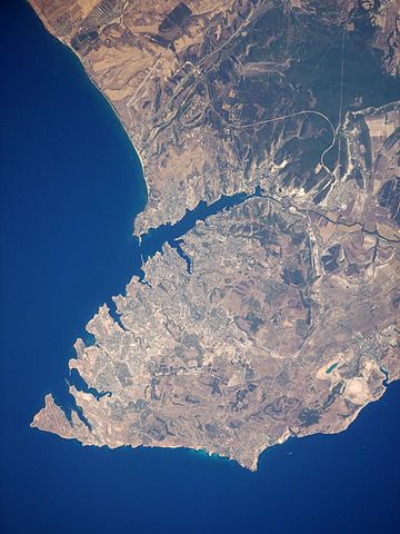
English: This satellite image highlights the jagged coastline of the southern Crimean Peninsula and the various docking areas of Sevastopol. The urban area is light grey, and it is bounded to the north and west by the Black Sea, to the south by vegetated (light green) and fallow (tan) agricultural fields, and to the east by the city of Inkerman and vegetated uplands (deep green). The city of Balaklava, to the south, houses another relic of the Cold War—an underground Soviet submarine base that is now open to the public as a monument. The Chernaya River issues into the Black Sea near Inkerman, flowing into the Sevastopol Inlet to the west.
|
||||||||||||||||||||||||||||||||||||||||||||||||||||||
| 日期 | |||||||||||||||||||||||||||||||||||||||||||||||||||||||
| 来源 | NASA Earth Observatory | ||||||||||||||||||||||||||||||||||||||||||||||||||||||
| 作者 | This image was taken by the Nasa Expedition 20 crew. | ||||||||||||||||||||||||||||||||||||||||||||||||||||||
Image acquired with a Nikon D3 digital camera fitted with a 400 mm lens, and is provided by the ISS Crew Earth Observations experiment and Image Science & Analysis Laboratory, Johnson Space Centre. Instrument: ISS - Digital Camera.
许可协议[编辑]
| 本文件完全由NASA创作,在美国属于公有领域。根据NASA的版权方针,NASA的材料除非另有声明否则不受版权保护。(参见Template:PD-USGov/zh、NASA版权方针页面或JPL图片使用方针。) | ||
 |
警告:
|
| 註解 | 該圖片含有註解:在維基媒體共享資源上查看註解 |
文件历史
点击某个日期/时间查看对应时刻的文件。
| 日期/时间 | 缩略图 | 大小 | 用户 | 备注 | |
|---|---|---|---|---|---|
| 当前 | 2015年1月20日 (二) 11:44 | | 1,080 × 1,440(455 KB) | Anonimski(留言 | 贡献) | Rotated to proper map orientation |
| 2009年8月24日 (一) 09:27 |  | 1,440 × 1,080(532 KB) | Originalwana(留言 | 贡献) | {{Information |Description={{en|1=This astronaut photograph highlights the jagged coastline of the southern Crimean Peninsula and the various docking areas of Sevastopol. The urban area is light grey, and it is bounded to the north and west by the Black S |
您不可以覆盖此文件。
文件用途
以下页面使用本文件:
全域文件用途
以下其他wiki使用此文件:
- af.wikipedia.org上的用途
- ast.wikipedia.org上的用途
- azb.wikipedia.org上的用途
- az.wikipedia.org上的用途
- bn.wikipedia.org上的用途
- ca.wikipedia.org上的用途
- de.wikipedia.org上的用途
- de.wikivoyage.org上的用途
- en.wikipedia.org上的用途
- es.wikipedia.org上的用途
- fa.wikipedia.org上的用途
- is.wikipedia.org上的用途
- it.wikipedia.org上的用途
- mn.wikipedia.org上的用途
- pl.wikipedia.org上的用途
- pl.wiktionary.org上的用途
- ru.wikipedia.org上的用途
- uk.wikipedia.org上的用途
- uk.wikivoyage.org上的用途
- www.wikidata.org上的用途
- zh.wikipedia.org上的用途