File:Sha Tau Kok Railway.png
跳去導覽
跳去搵嘢
預覽大細:800 × 490 像素。 第啲解像度:320 × 196 像素 | 640 × 392 像素 | 1,024 × 627 像素 | 1,518 × 929 像素。
原本檔案 (1,518 × 929 像素,檔案大細:665 KB ,MIME類型:image/png)
Captions
Captions
Add a one-line explanation of what this file represents
| 描述 |
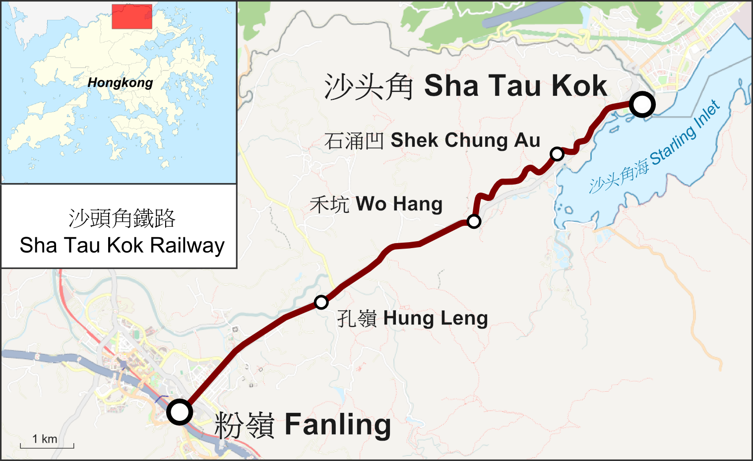
Deutsch: Karte der Sha Tau Kok Railway in Hongkong English: Map of the Sha Tau Kok Railway in Hongkong |
| 日期 | |
| 來源 |
自己作品 Map was created using:
|
| 作者 | |
| 許可 (重用呢個檔案) |
Map data (c) OpenStreetMap (and) contributors, CC-BY-SA |

|
This rail transport map image could be recreated using vector graphics as an SVG file. This has several advantages; see Commons:Media for cleanup for more information. If an SVG form of this image is already available, please upload it. After uploading an SVG, replace this template with {{vector version available|new image name.svg}}.
|
This file is licensed under the Creative Commons Attribution-Share Alike 2.0 Generic license.
- 你可以:
- 去分享 – 複製、發佈同傳播呢個作品
- 再改 – 創作演繹作品
- 要遵照下面嘅條件:
- 署名 – 你一定要畀合適嘅表彰、畀返指向呢個授權條款嘅連結,同埋寫明有無改過嚟。你可以用任何合理方式去做,但唔可以用任何方式暗示授權人認可咗你或者你嘅使用方式。
- 相同方式分享 – 如果你用任何方式改過呢個作品,你必須要用返原本或者相似嘅條款發佈。
檔案歷史
撳個日期/時間去睇響嗰個時間出現過嘅檔案。
| 日期/時間 | 縮圖 | 尺寸 | 用戶 | 註解 | |
|---|---|---|---|---|---|
| 現時 | 2015年7月25號 (六) 03:14 | | 1,518 × 929(665 KB) | Pechristener(傾偈 | 貢獻) | Hung Ling Station located more to the west according co-ordinates of the pic in commons. |
| 2015年1月13號 (二) 08:52 |  | 1,518 × 929(665 KB) | Pechristener(傾偈 | 貢獻) | Layout nachgebessert | |
| 2015年1月13號 (二) 08:42 |  | 1,518 × 929(659 KB) | Pechristener(傾偈 | 貢獻) | {{Information |Description={{de|1=Karte der Sha Tau Kok Railway in Hongkong}}{{en|1=Map of the Sha Tau Kok Railway}} |Source ={{own}} Map was created using: *[http://www.openstreetmap.or... |
你無得衾咗個檔案。
檔案用途
以下嘅5版用到呢個檔:
全域檔案使用情況
下面嘅維基都用緊呢個檔案:
- de.wikipedia.org嘅使用情況
- en.wikipedia.org嘅使用情況
- zh-yue.wikipedia.org嘅使用情況