File:Shag Harbour Nova Scotia.gif
跳转到导航
跳转到搜索
没有更高的分辨率。
Shag_Harbour_Nova_Scotia.gif (405 × 405像素,文件大小:75 KB,MIME类型:image/gif、0.1秒)
说明
说明
添加一行文字以描述该文件所表现的内容
摘要
[编辑]
| 描述 |
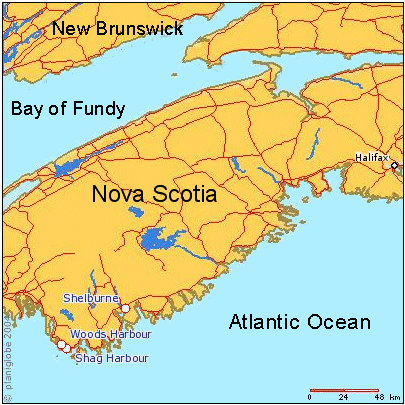
English: Map of southern Nova Scotia, Canada, showing location of Shag Harbour, N.S. and other locations involved in the 1967 Shag Harbour UFO incident. |
| 日期 | 未知日期 |
| 来源 | Planiglobe |
| 作者 | Planiglobe |
许可协议
[编辑]
| This image is from Planiglobe. All maps hosted on Planiglobe are licensed under the Creative Commons Attribution 2.5 License, but Planiglobe suggests that they not be used for navigational purposes. For the purposes of this license, this clause is considered a disclaimer and not a license restriction. |

|
此map图片可使用矢量图形重新创建为SVG文件。这具有很多好处;更多信息请参见共享资源:待清理媒体。如果存在此图片的SVG格式,请将其上传,然后将此模板替换为
{{vector version available|新图片名称}}。
建议您将SVG命名为“Shag Harbour Nova Scotia.svg”,这样在使用Vector version available(或Vva)模板时就不需要填写新图片名称参数。 |
文件历史
点击某个日期/时间查看对应时刻的文件。
| 日期/时间 | 缩略图 | 大小 | 用户 | 备注 | |
|---|---|---|---|---|---|
| 当前 | 2011年9月13日 (二) 17:28 | | 405 × 405(75 KB) | SreeBot(留言 | 贡献) | (Original text) : spelling corrections (Harbor -> Harbour) |
| 2011年9月13日 (二) 17:28 |  | 405 × 405(104 KB) | SreeBot(留言 | 贡献) | (Original text) : Map of southern Nova Scotia, Canada, showing location of Shag Harbour, N.S. and other locations involved in the 1967 Shag Harbour UFO incident. User-made map derived from planiform.com, under their Creative Commons Attribution 2.5 lic |
您不可以覆盖此文件。
文件用途
没有页面使用本文件。
全域文件用途
以下其他wiki使用此文件:
- en.wikipedia.org上的用途
- fr.wikipedia.org上的用途
- sr.wikipedia.org上的用途
- vi.wikipedia.org上的用途
- zh.wikipedia.org上的用途