File:Shepherd-c-030-031.jpg

Pradinė rinkmena (1 989 × 1 528 taškų, rinkmenos dydis: 629 KiB, MIME tipas: image/jpeg)
Captions
Captions
Aprašymas
[keisti]
| Aprašymas |
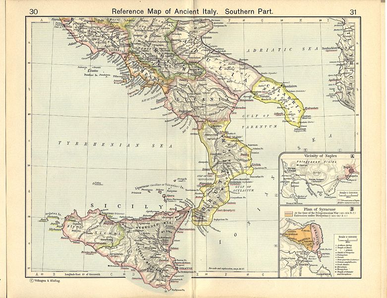
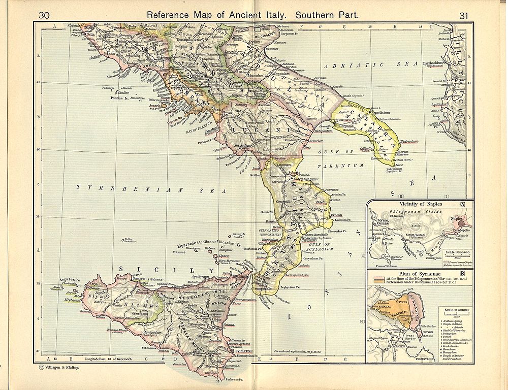
English: Reference Map of Ancient Italy, Southern Part [1]
Historical Atlas by William R. Shepherd, 1911. Courtesy of the University of Texas Libraries, The University of Texas at Austin. From The Historical Atlas by William R. Shepherd, 1911 edition |
| Data | m. kovo 7 d. (upload date) |
| Šaltinis | Historical Atlas by William R. Shepherd 1911 edition |
| Autorius | Historical Atlas by William R. Shepherd 1911 edition |
| Leidimas (Šios rinkmenos panaudojimas kitur) |
This image is in the public domain due to its age. See also http://www.lib.utexas.edu/usage_statement.html?maps=yes |
![[1]](http://www.lib.utexas.edu/maps/historical/shepherd_1911/shepherd-c-030-031.jpg)
Licencija
[keisti]
|
Šis failas yra viešo naudojimo tose šalyse, kuriose autorių teisės galiojimo netenka po 70 metų nuo autoriaus mirties.
| |
| This file has been identified as being free of known restrictions under copyright law, including all related and neighboring rights. | |
This media file is in the public domain in the United States. This applies to U.S. works where the copyright has expired, often because its first publication occurred prior to January 1, 1929, and if not then due to lack of notice or renewal. See this page for further explanation.
|
 | |
 |
This image might not be in the public domain outside of the United States; this especially applies in the countries and areas that do not apply the rule of the shorter term for US works, such as Canada, Mainland China (not Hong Kong or Macao), Germany, Mexico, and Switzerland. The creator and year of publication are essential information and must be provided. See Wikipedia:Public domain and Wikipedia:Copyrights for more details.
|
Rinkmenos istorija
Paspauskite ant datos/laiko, kad pamatytumėte rinkmeną tokią, kokia ji buvo tuo metu.
| Data/Laikas | Miniatiūra | Matmenys | Naudotojas | Paaiškinimas | |
|---|---|---|---|---|---|
| dabartinis | 08:05, 1 liepos 2007 | | 1 989 × 1 528 (629 KiB) | Accurimbono (aptarimas | indėlis) | == Summary == Map of South Italy during the Roman period. Extracted from ''The Historical Atlas'' by William R. Shepherd, 1911. Original image is at http://www.lib.utexas.edu/maps/historical/shepherd_1911/shepherd-c-026-027.jpg [[C |
Jūs negalite perrašyti šios rinkmenos.
Rinkmenos naudojimas
Šie puslapiai naudoja šią rinkmeną:
_-_1911.png)
Visuotinis rinkmenos naudojimas
Ši rinkmena naudojama šiose viki svetainėse:
- Naudojama ar.wikipedia.org
- Naudojama ast.wikipedia.org
- Naudojama ca.wikipedia.org
- Naudojama de.wikipedia.org
- Naudojama el.wikipedia.org
- Naudojama en.wikipedia.org
- Naudojama es.wikipedia.org
- Naudojama et.wikipedia.org
- Naudojama fr.wikipedia.org
- Naudojama it.wikipedia.org
- Matera
- Cosenza
- Provincia (storia romana)
- Lucania
- Manduria
- Atena Lucana
- Modugno (Italia)
- Monopoli (Italia)
- Noicattaro
- Ordona
- Barletta
- Canosa di Puglia
- Paestum
- Canne
- Vieste
- Aequum Tuticum
- Eraclea (Magna Grecia)
- Siri (Lucania)
- Egnazia
- Vereto
- Rudiae
- Potenza (Italia)
- Regio III Lucania et Bruttii
- Larinum
- Banzi
- Altamura
- Regio II Apulia et Calabria
- Elea-Velia
- Alezio
- Italia romana
Žiūrėti visuotinį šios rinkmenos naudojimą.
Metaduomenys
- Historical Atlas by William R. Shepherd
- Maps showing history by William R. Shepherd
- Old maps of Lazio
- Old maps of Campania
- Old maps of Calabria
- Old maps of Basilicata
- Old maps of Apulia
- Old maps of Sicily
- Old maps of Syracuse
- Maps of Syrakousai
- Maps of Magna Graecia
- Old maps of Samnium
- Old maps of Roman Italy
- Bruttii