File:Shepherd-c-030-031.jpg
跳至導覽
跳至搜尋

預覽大小:781 × 600 像素。 其他解析度:313 × 240 像素 | 625 × 480 像素 | 1,000 × 768 像素 | 1,280 × 983 像素 | 1,989 × 1,528 像素。
原始檔案 (1,989 × 1,528 像素,檔案大小:629 KB,MIME 類型:image/jpeg)
說明
說明
添加單行說明來描述出檔案所代表的內容
摘要[編輯]
| 描述 |
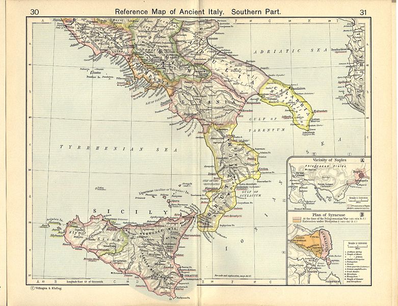
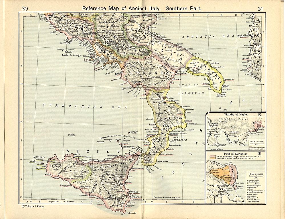
English: Reference Map of Ancient Italy, Southern Part [1]
Historical Atlas by William R. Shepherd, 1911. Courtesy of the University of Texas Libraries, The University of Texas at Austin. From The Historical Atlas by William R. Shepherd, 1911 edition |
| 日期 | 2008年3月7日 (上傳日期) |
| 來源 | Historical Atlas by William R. Shepherd 1911 edition |
| 作者 | Historical Atlas by William R. Shepherd 1911 edition |
| 授權許可 (重用此檔案) |
This image is in the public domain due to its age. See also http://www.lib.utexas.edu/usage_statement.html?maps=yes |
![[1]](http://www.lib.utexas.edu/maps/historical/shepherd_1911/shepherd-c-030-031.jpg)
授權條款[編輯]
|
本作品在其來源國以及其他著作權期限是作者逝世後70年或以下的國家與地區屬於公有領域。
| |
| 此作品無已知的著作權限制,亦不受所有相關和鄰接的權利限制。 | |
|
|
 | |
 |
檔案歷史
點選日期/時間以檢視該時間的檔案版本。
| 日期/時間 | 縮圖 | 尺寸 | 使用者 | 備註 | |
|---|---|---|---|---|---|
| 目前 | 2007年7月1日 (日) 08:05 | | 1,989 × 1,528(629 KB) | Accurimbono(留言 | 貢獻) | == Summary == Map of South Italy during the Roman period. Extracted from ''The Historical Atlas'' by William R. Shepherd, 1911. Original image is at http://www.lib.utexas.edu/maps/historical/shepherd_1911/shepherd-c-026-027.jpg [[C |
無法覆蓋此檔案。
檔案用途
下列4個頁面有用到此檔案:
_-_1911.png)
全域檔案使用狀況
以下其他 wiki 使用了這個檔案:
- ar.wikipedia.org 的使用狀況
- ast.wikipedia.org 的使用狀況
- ca.wikipedia.org 的使用狀況
- de.wikipedia.org 的使用狀況
- el.wikipedia.org 的使用狀況
- en.wikipedia.org 的使用狀況
- es.wikipedia.org 的使用狀況
- et.wikipedia.org 的使用狀況
- fr.wikipedia.org 的使用狀況
- it.wikipedia.org 的使用狀況
- Matera
- Cosenza
- Provincia (storia romana)
- Lucania
- Manduria
- Atena Lucana
- Modugno (Italia)
- Monopoli (Italia)
- Noicattaro
- Ordona
- Barletta
- Canosa di Puglia
- Paestum
- Canne
- Vieste
- Aequum Tuticum
- Eraclea (Magna Grecia)
- Siri (Lucania)
- Egnazia
- Vereto
- Rudiae
- Potenza (Italia)
- Regio III Lucania et Bruttii
- Larinum
- Banzi
- Altamura
- Regio II Apulia et Calabria
- Elea-Velia
- Alezio
- Italia romana
檢視此檔案的更多全域使用狀況。
詮釋資料
分類:
- Historical Atlas by William R. Shepherd
- Maps showing history by William R. Shepherd
- Old maps of Lazio
- Old maps of Campania
- Old maps of Calabria
- Old maps of Basilicata
- Old maps of Apulia
- Old maps of Sicily
- Old maps of Syracuse
- Maps of Syrakousai
- Maps of Magna Graecia
- Old maps of Samnium
- Old maps of Roman Italy
- Bruttii