File:Simplified Languages of Europe map.svg
Skočit na navigaci
Skočit na vyhledávání

Velikost tohoto PNG náhledu tohoto SVG souboru: 737 × 599 pixelů. Jiná rozlišení: 295 × 240 pixelů | 590 × 480 pixelů | 945 × 768 pixelů | 1 259 × 1 024 pixelů | 2 519 × 2 048 pixelů | 1 541 × 1 253 pixelů.
Původní soubor (soubor SVG, nominální rozměr: 1 541 × 1 253 pixelů, velikost souboru: 2,25 MB)
Popisky
Popisky
Přidejte jednořádkové vysvětlení, co tento soubor představuje
Popis[editovat]
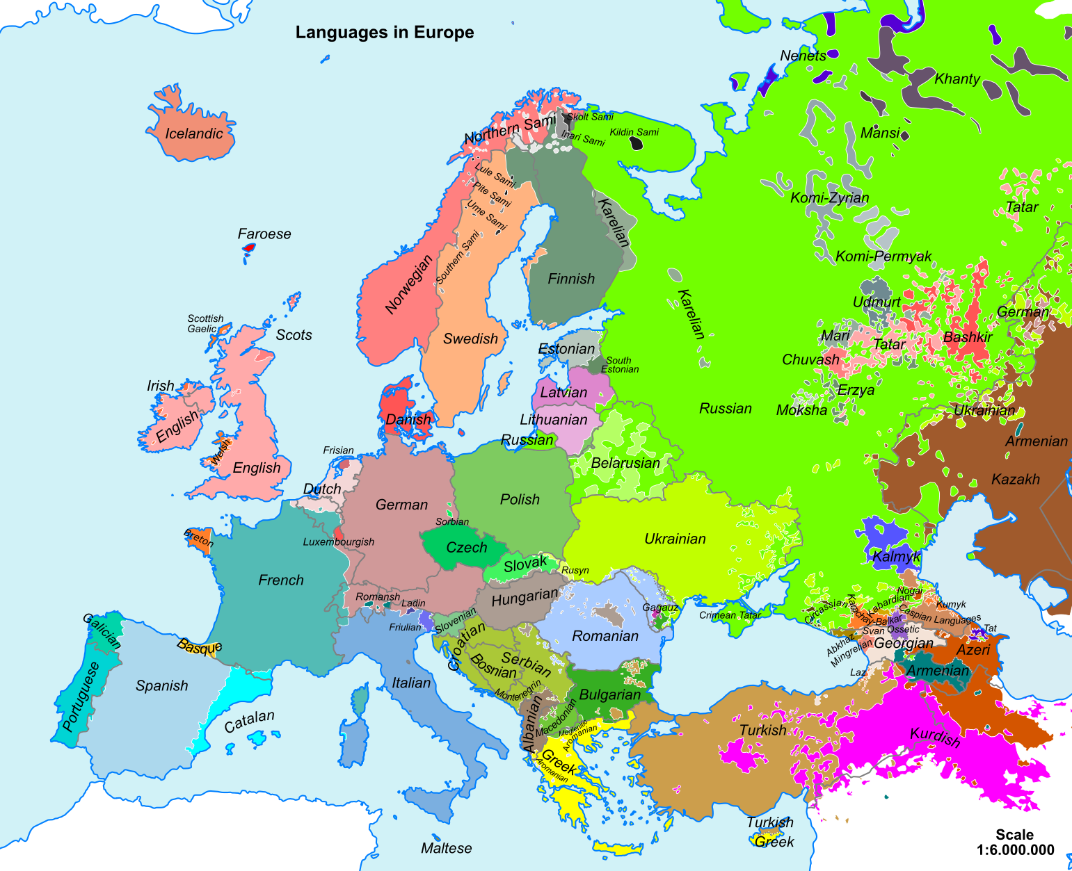
| Popis | Map of main European languages simplified by following national borders in many cases. The map does not reflect the fact that many regions are bilingual, officially and/or in practice. In some cases, the area indicated for a language reflects where some of its speakers live but not necessarily where they form the majority of the population. |
| Datum | 22. listopadu 2008 (datum prvotního načtení souboru) |
| Zdroj |
Vlastní dílo Sources for data:
|
| Autor |
viz níže / [] By language codes: SVG, jpg, png; English: SVG , simplified SVG , rectified PNG ; Esperanto 1 , 2 , 3 , français , македонскиעברית |
| SVG vývoj |

Licence[editovat]
| Já, autor tohoto díla, jej tímto uvolňuji jako volné dílo, a to celosvětově. V některých zemích to není podle zákona možné; v takovém případě: Poskytuji komukoli právo užívat toto dílo za libovolným účelem, a to bezpodmínečně s výjimkou podmínek vyžadovaných zákonem. |
Historie souboru
Kliknutím na datum a čas se zobrazí tehdejší verze souboru.
| Datum a čas | Náhled | Rozměry | Uživatel | Komentář | |
|---|---|---|---|---|---|
| současná | 6. 7. 2023, 18:54 | | 1 541 × 1 253 (2,25 MB) | Petnog (diskuse | příspěvky) | Almost no one speaks only mirandese (and either way, it's not spanish). Also, barranquenho is a portuguese dialect, despite having spanish influence |
| 9. 2. 2022, 11:26 |  | 1 541 × 1 253 (2,25 MB) | Parodper (diskuse | příspěvky) | Fixed Galician borders | |
| 21. 3. 2021, 03:08 |  | 1 541 × 1 253 (2,25 MB) | YoungstownToast (diskuse | příspěvky) | Reverted to version as of 14:40, 8 March 2019 (UTC). Incorrect | |
| 10. 1. 2020, 13:17 |  | 1 541 × 1 253 (2,28 MB) | ZxcvU (diskuse | příspěvky) | More accurate borders of Ukrainian. | |
| 8. 3. 2019, 14:40 |  | 1 541 × 1 253 (2,25 MB) | NikNaks (diskuse | příspěvky) | Revert to true SVG; if you wish to remove content or make edits, please do so in Inkscape or another vector editor, do not upload a PNG in an SVG wrapper | |
| 9. 2. 2019, 12:15 |  | 1 420 × 1 320 (990 KB) | A2D2 (diskuse | příspěvky) | Reverted to version as of 22:30, 23 February 2017 (UTC) This file is only about the languages in Europe. | |
| 11. 1. 2019, 20:33 |  | 1 541 × 1 253 (2,25 MB) | Kun Kipcsak (diskuse | příspěvky) | Added the Hungarian speakers from romanian Moldova > the Csango speech of north and south (Săbăoani and Pustiana; Faraoani), also with hungarian of Csangos of Ghimeș, Bacău. | |
| 27. 3. 2018, 00:06 |  | 1 541 × 1 253 (2,25 MB) | R9tgokunks (diskuse | příspěvky) | tweaking Romance languages in France & Italy per File:Romance_20c_en.png and File:Romance_languages.png | |
| 21. 12. 2017, 11:11 |  | 1 541 × 1 253 (2,29 MB) | DiaouligRu (diskuse | příspěvky) | Added Breton speaking populations according to File:Indo-European_languages_in_Europe.png, File:Percentage_of_breton_speakers_in_the_breton_countries_in_2004.png and File:Image-Languages-Europe.png. | |
| 24. 2. 2017, 09:45 |  | 1 600 × 1 320 (2,28 MB) | Scooter20 (diskuse | příspěvky) | Please remake your changes in SVG not bitmap as there is a huge drop in quality after your changes. Also not sure about removing adjacent or "sometimes included in Europe" countries from the map. |
Tento soubor nemůžete přepsat.
Využití souboru
Na Commons na soubor odkazují tyto stránky:
- User:Chumwa/OgreBot/Travel and communication maps/2016 February 10-19
- User:Chumwa/OgreBot/Travel and communication maps/2016 February 20-29
- User:Chumwa/OgreBot/Travel and communication maps/2017 December 21-31
- User:Chumwa/OgreBot/Travel and communication maps/2017 February 10-18
- User:Chumwa/OgreBot/Travel and communication maps/2017 February 19-28
- User:Chumwa/OgreBot/Travel and communication maps/2018 March 21-31
- User:Chumwa/OgreBot/Travel and communication maps/2019 February 1-9
- User:Chumwa/OgreBot/Travel and communication maps/2019 January 11-20
- User:Chumwa/OgreBot/Travel and communication maps/2019 March 1-10
- User:Chumwa/OgreBot/Travel and communication maps/2020 January 1-10
- User:Chumwa/OgreBot/Travel and communication maps/2021 March 21-31
- User:Chumwa/OgreBot/Travel and communication maps/2022 February 1-9
- User:Chumwa/OgreBot/Travel and communication maps/2023 July 1-10
- User:Magog the Ogre/Multilingual legend/2021 March 21-31
- User:Magog the Ogre/Multilingual legend/2022 February 1-9
- User:Magog the Ogre/Multilingual legend/2023 July 1-10
- User talk:Scooter20
- File:Germany Name European Languages.svg
- File:Germany Name European Languages de.svg
- File:Languages Europe.png
- File:Languages Europe.svg
- File:Schbrooche vo Europa.png
- File:Simplified Languages of Europe map-fr.svg
- File:Word for Wine in European languages.svg
Globální využití souboru
Tento soubor využívají následující wiki:
- Využití na cs.wikipedia.org
- Využití na de.wikipedia.org
- Využití na el.wikipedia.org
- Využití na en.wikipedia.org
- Využití na en.wiktionary.org
- Využití na es.wikipedia.org
- Využití na gl.wikipedia.org
- Využití na hu.wikipedia.org
- Využití na hy.wikipedia.org
- Využití na hyw.wikipedia.org
- Využití na ka.wikipedia.org
- Využití na ko.wikipedia.org
- Využití na lfn.wikipedia.org
- Využití na li.wikibooks.org
- Využití na lt.wikipedia.org
Zobrazit další globální využití tohoto souboru.