File:Sistema de Mapa de Metro Ligeiro de Macau.png
跳至導覽
跳至搜尋

預覽大小:333 × 598 像素。 其他解析度:133 × 240 像素 | 267 × 480 像素 | 427 × 768 像素 | 570 × 1,024 像素 | 2,500 × 4,492 像素。
原始檔案 (2,500 × 4,492 像素,檔案大小:813 KB,MIME 類型:image/png)
說明
說明
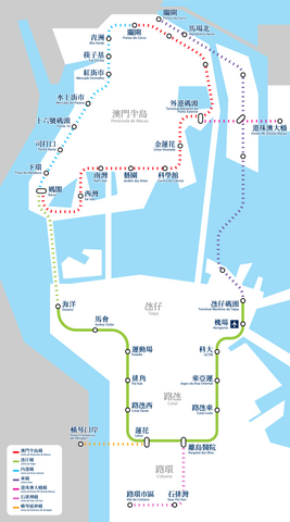
澳門輕軌系統路線圖
摘要
[編輯]
| 描述 |
中文(繁體):澳門輕軌系統路線圖
中文(简体):澳门轻轨系统路线图
Português: Mapa da Rede do Metro Ligeiro de Macau
English: Macau LRT System Map |
| 來源 | Tinho C. (talk) |
| 作者 | Tinho C. (talk), K. C. Ho (talk) |
授權條款
[編輯]
我,本作品的著作權持有者,決定用以下授權條款發佈本作品:
此檔案採用創用CC 姓名標示-相同方式分享 3.0 未在地化版本授權條款。
- 您可以自由:
- 分享 – 複製、發佈和傳播本作品
- 重新修改 – 創作演繹作品
- 惟需遵照下列條件:
- 姓名標示 – 您必須指名出正確的製作者,和提供授權條款的連結,以及表示是否有對內容上做出變更。您可以用任何合理的方式來行動,但不得以任何方式表明授權條款是對您許可或是由您所使用。
- 相同方式分享 – 如果您利用本素材進行再混合、轉換或創作,您必須基於如同原先的相同或兼容的條款,來分布您的貢獻成品。
檔案歷史
點選日期/時間以檢視該時間的檔案版本。
| 日期/時間 | 縮圖 | 尺寸 | 使用者 | 備註 | |
|---|---|---|---|---|---|
| 目前 | 2023年10月3日 (二) 02:07 | | 2,500 × 4,492(813 KB) | Gwingman(留言 | 貢獻) | Updated Lotus Station |
| 2021年11月1日 (一) 18:14 |  | 2,500 × 4,492(830 KB) | Gwingman(留言 | 貢獻) | Remove header | |
| 2020年12月28日 (一) 17:42 |  | 2,500 × 4,955(652 KB) | Gwingman(留言 | 貢獻) | Stronger the stroke | |
| 2020年10月13日 (二) 04:57 |  | 2,500 × 4,955(1.01 MB) | Gwingman(留言 | 貢獻) | Align color with wikipedia's | |
| 2020年10月13日 (二) 02:56 |  | 2,500 × 4,955(1.01 MB) | Gwingman(留言 | 貢獻) | Update Linha Leste | |
| 2019年6月29日 (六) 06:16 |  | 2,500 × 4,955(750 KB) | Gwingman(留言 | 貢獻) | Update according to a report published by CA Macau - http://www.ca.gov.mo/files/SA1318cn.pdf | |
| 2019年5月14日 (二) 20:34 |  | 2,500 × 4,955(770 KB) | Gwingman(留言 | 貢獻) | Improve display of SPV Line | |
| 2019年5月3日 (五) 00:01 |  | 2,500 × 4,955(758 KB) | Gwingman(留言 | 貢獻) | Change SPV Line | |
| 2019年2月8日 (五) 06:59 |  | 2,500 × 4,955(804 KB) | Gwingman(留言 | 貢獻) | 加入模擬字樣 | |
| 2019年2月8日 (五) 06:48 |  | 2,500 × 4,955(798 KB) | Gwingman(留言 | 貢獻) | 改用宋體以強化字重 |
無法覆蓋此檔案。
檔案用途
下列28個頁面有用到此檔案:
- User:Chumwa/OgreBot/Potential transport maps/2018 June 11-20
- User:Chumwa/OgreBot/Potential transport maps/2019 February 1-9
- User:Chumwa/OgreBot/Potential transport maps/2019 June 21-30
- User:Chumwa/OgreBot/Potential transport maps/2019 May 1-10
- User:Chumwa/OgreBot/Potential transport maps/2019 May 11-20
- User:Chumwa/OgreBot/Public transport information/2018 June 11-20
- User:Chumwa/OgreBot/Public transport information/2019 February 1-9
- User:Chumwa/OgreBot/Public transport information/2019 June 21-30
- User:Chumwa/OgreBot/Public transport information/2019 May 1-10
- User:Chumwa/OgreBot/Public transport information/2019 May 11-20
- User:Chumwa/OgreBot/Public transport information/2020 December 21-31
- User:Chumwa/OgreBot/Public transport information/2020 October 11-20
- User:Chumwa/OgreBot/Public transport information/2021 November 1-10
- User:Chumwa/OgreBot/Public transport information/2023 October 1-10
- User:Chumwa/OgreBot/Transport Maps/2018 June 11-20
- User:Chumwa/OgreBot/Transport Maps/2019 February 1-9
- User:Chumwa/OgreBot/Transport Maps/2019 June 21-30
- User:Chumwa/OgreBot/Transport Maps/2019 May 1-10
- User:Chumwa/OgreBot/Transport Maps/2019 May 11-20
- User:Chumwa/OgreBot/Transport Maps/2020 December 21-31
- User:Chumwa/OgreBot/Transport Maps/2020 October 11-20
- User:Chumwa/OgreBot/Transport Maps/2021 November 1-10
- User:Chumwa/OgreBot/Transport Maps/2023 October 1-10
- User:Chumwa/OgreBot/Travel and communication maps/2018 June 11-20
- User:Chumwa/OgreBot/Travel and communication maps/2019 February 1-9
- User:Chumwa/OgreBot/Travel and communication maps/2019 June 21-30
- User:Chumwa/OgreBot/Travel and communication maps/2019 May 1-10
- User:Chumwa/OgreBot/Travel and communication maps/2019 May 11-20
全域檔案使用狀況
以下其他 wiki 使用了這個檔案:
- en.wikipedia.org 的使用狀況
- ja.wikipedia.org 的使用狀況
- ru.wikipedia.org 的使用狀況
- th.wikipedia.org 的使用狀況
- zh-yue.wikipedia.org 的使用狀況
- zh.wikipedia.org 的使用狀況