File:Slave and Free States before the American Civil War.svg
Zur Navigation springen
Zur Suche springen

Größe der PNG-Vorschau dieser SVG-Datei: 800 × 502 Pixel. Weitere Auflösungen: 320 × 201 Pixel | 640 × 401 Pixel | 1.024 × 642 Pixel | 1.280 × 803 Pixel | 2.560 × 1.605 Pixel | 882 × 553 Pixel.
Originaldatei (SVG-Datei, Basisgröße: 882 × 553 Pixel, Dateigröße: 105 KB)
Bildtexte
Kurzbeschreibungen
Ergänze eine einzeilige Erklärung, was diese Datei darstellt.
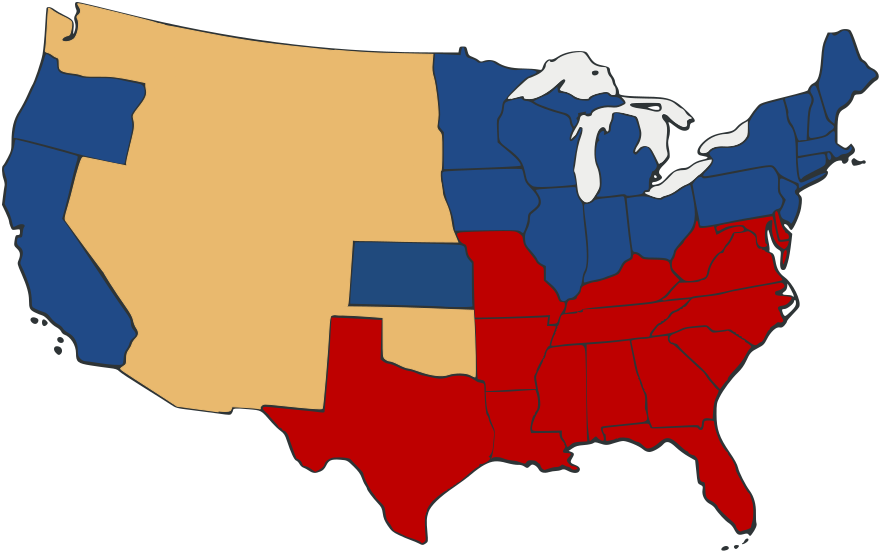
| Beschreibung | Free and Slave States in the period leading to the American Civil War. Free states are blue, slave states in red. Territories are a neutral yellow. | ||
| Datum | |||
| Quelle | Based on Image:US_Secession_map_1865.svg with information from en:Image:Freeandslavestates.gif | ||
| Urheber | Self-made from public domain work Image:US_Secession_map_1865.svg | ||
| Genehmigung (Weiternutzung dieser Datei) |
|
||
| Andere Versionen |
 |
Dateiversionen
Klicke auf einen Zeitpunkt, um diese Version zu laden.
| Version vom | Vorschaubild | Maße | Benutzer | Kommentar | |
|---|---|---|---|---|---|
| aktuell | 23:05, 27. Sep. 2007 | | 882 × 553 (105 KB) | Adam Cuerden (Diskussion | Beiträge) | Fixed the borders in th e territories by muckin' 'em around. |
| 22:59, 27. Sep. 2007 |  | 882 × 553 (104 KB) | Adam Cuerden (Diskussion | Beiträge) | {{Information |Description= |Source= Based on Image:US_Secession_map_1865.svg with information from en:Image:Freeandslavestates.gif |Date=2007 |Author=Self-made from public domain work Image:US_Secession_map_1865.svg |Permission={{PD-retouc |
Du kannst diese Datei nicht überschreiben.
Dateiverwendung
Die folgenden 3 Seiten verwenden diese Datei:
Globale Dateiverwendung
Die nachfolgenden anderen Wikis verwenden diese Datei:
- Verwendung auf de.wikipedia.org
- Verwendung auf en.wikipedia.org
- Verwendung auf fr.wikipedia.org
- Verwendung auf io.wikipedia.org
- Verwendung auf it.wikipedia.org
- Verwendung auf la.wikipedia.org
- Verwendung auf no.wikipedia.org
- Verwendung auf pl.wikipedia.org