File:South-east frontier of France after the Treaty of Paris, 1814.jpg
ნავიგაციაზე გადასვლა
ძიებაზე გადასვლა

ზომა წინასწარი გადახედვისას: 468 × 600 პიქსელი. სხვა გაფართოება: 187 × 240 პიქსელი | 374 × 480 პიქსელი | 599 × 768 პიქსელი | 799 × 1 024 პიქსელი | 1 648 × 2 112 პიქსელი.
თავდაპირველი ფაილი (1 648 × 2 112 პიქსელი, ფაილის ზომა: 1,71 მბ, MIME ტიპი: image/jpeg)
Captions
Captions
Add a one-line explanation of what this file represents
რეზიუმე[რედაქტირება]
| აღწერა |
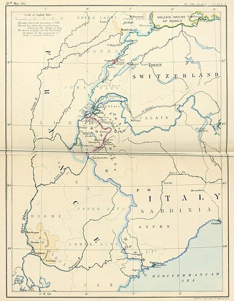
English: South-east frontier of France after the Treaty of Paris, 1814 |
| თარიღი | |
| წყარო | Edward Hertslet (1875). The map of Europe by treaty; showing the various political and territorial changes which have taken place since the general peace of 1814, London, Butterworths. p. opposite 28, 351 |
| ავტორი | Edward Hertslet; and Stafford's Geng Estab, 55 Charing Cross |
ლიცენზია[რედაქტირება]
|
This work is in the public domain in its country of origin and other countries and areas where the copyright term is the author's life plus 70 years or fewer. This work is in the public domain in the United States because it was published (or registered with the U.S. Copyright Office) before January 1, 1929. | |
| This file has been identified as being free of known restrictions under copyright law, including all related and neighboring rights. | |
ფაილის ისტორია
დააწკაპუნეთ თარიღზე/დროზე, რათა იხილოთ ფაილი, როგორც ის მაშინ გამოიყურებოდა.
| თარიღი/დრო | მინიატიურა | განზომილებები | მომხმარებელი | კომენტარი | |
|---|---|---|---|---|---|
| მიმდინარე | 21:31, 3 სექტემბერი 2014 | | 1 648 × 2 112 (1,71 მბ) | PBS (განხილვა | წვლილი) | User created page with UploadWizard |
თქვენ არ შეგიძლიათ ამ ფაილზე გადაწერა.
ფაილის გამოყენება
ეს ფაილი არცერთ გვერდზე არ გამოიყენება.
ფაილის გლობალური გამოყენება
ეს ფაილი გამოიყენება შემდეგ ვიკებში:
- გამოყენება ar.wikipedia.org-ში
- გამოყენება en.wikipedia.org-ში
- გამოყენება es.wikipedia.org-ში
- გამოყენება fr.wikipedia.org-ში
- გამოყენება he.wikipedia.org-ში
- გამოყენება it.wikipedia.org-ში
- გამოყენება ja.wikipedia.org-ში
- გამოყენება ka.wikipedia.org-ში
- გამოყენება pnb.wikipedia.org-ში
- გამოყენება pt.wikipedia.org-ში
- გამოყენება pt.wikiquote.org-ში
- გამოყენება sr.wikipedia.org-ში
- გამოყენება tt.wikipedia.org-ში
- გამოყენება uk.wikipedia.org-ში
- გამოყენება ur.wikipedia.org-ში