File:South-eastern Europe 1040.jpg
Mine navigeerimisribale
Mine otsikasti

Selle eelvaate suurus: 776 × 600 pikslit. Teised eraldusvõimed: 311 × 240 pikslit | 621 × 480 pikslit | 994 × 768 pikslit | 1122 × 867 pikslit.
Algfail (1122 × 867 pikslit, faili suurus: 332 KB, MIME tüüp: image/jpeg)
Pealdised
Pealdised
Lisa üherealine seletus sellest, mida fail esitab
Lühikirjeldus[muuda]
| Kirjeldus |
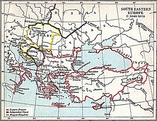
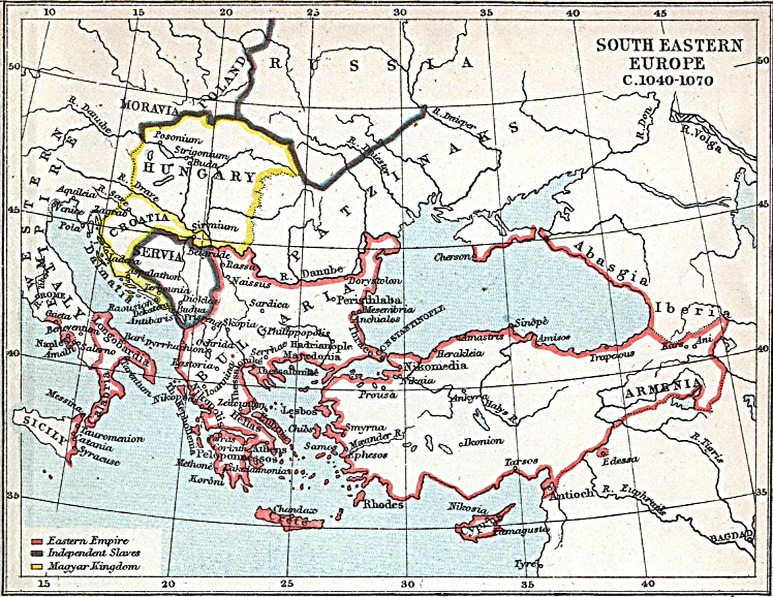
English: Map of south-eastern Europe and Asia Minor c. 1040 AD |
| Kuupäev | |
| Allikas | Map at the Perry-Castañeda Library Map Collection of the University of Texas |
| Autor | J.B. Bury |
Litsents[muuda]
See teos on Ameerika Ühendriikides avalikus omandis. See käib Ameerika Ühendriikide teoste kohta, mille autoriõigus on aegunud. Põhjuseks võib olla teose avaldamine enne 1. jaanuari 1929. aastal. Täpsema teabe leiad sellelt leheküljelt.
|
 | |
 |
Väljaspool Ameerika Ühendriike ei pruugi see pilt avalikus omandis olla (eriti riikides, nagu Hiina (välja arvatud Hongkong ja Aomen), Kanada, Mehhiko, Saksamaa ja Šveits, kus Ameerika Ühendriikide teostele ei kohaldu lühem autoriõiguse kehtivus). Autor ja avaldamisaasta peavad pildi juures märgitud olema. Täiendava teabe jaoks vaata lehekülgi Wikipedia:Public domain ja Wikipedia:Copyrights.
|
Faili ajalugu
Klõpsa kuupäeva ja kellaaega, et näha sel ajahetkel kasutusel olnud failiversiooni.
| Kuupäev/kellaaeg | Pisipilt | Mõõtmed | Kasutaja | Kommentaar | |
|---|---|---|---|---|---|
| viimane | 29. märts 2010, kell 12:15 | | 1122 × 867 (332 KB) | Cplakidas (arutelu | kaastöö) | {{Information |Description={{en|1=Map of south-eastern Europe and Asia Minor ca. 1040 AD}} |Source=[http://www.lib.utexas.edu/maps/historical/se_europe_1040.jpg Map] at the [http://www.lib.utexas.edu/maps/ Perry-Castañeda Library Map Collection] of the U |
Sa ei saa seda faili üle kirjutada.
Faili kasutus
Seda faili kasutab järgmine lehekülg:
Globaalne failikasutus
Järgmised muud vikid kasutavad seda faili:
- Faili kasutus vikis ast.wikipedia.org
- Faili kasutus vikis ba.wikipedia.org
- Faili kasutus vikis ca.wikipedia.org
- Faili kasutus vikis eo.wikipedia.org
- Faili kasutus vikis et.wikipedia.org
- Faili kasutus vikis he.wikipedia.org
- Faili kasutus vikis hr.wikipedia.org
- Faili kasutus vikis ro.wikipedia.org
- Faili kasutus vikis ru.wikipedia.org
- Faili kasutus vikis ru.wikinews.org
- Faili kasutus vikis ru.wikiquote.org
- Faili kasutus vikis sh.wikipedia.org
- Faili kasutus vikis tr.wikipedia.org
- Faili kasutus vikis uk.wikipedia.org
- Faili kasutus vikis www.wikidata.org
Metaandmed
Kategooriad:
- Atlas To Freeman's Historical Geography
- Old maps of the Byzantine Empire
- Old maps of Moravia
- Maps of the history of Hungary in the Árpád age
- Maps of 11th-century Serbia
- Maps of the history of Croatia in the Middle Ages
- Maps of the history of Romania in the Middle Ages
- Maps of the history of Bulgaria in the Middle Ages
- Maps showing 1040
- Europe in the 1040s
- Europe in the 11th century
- Romania in the 11th century
- 1040 in Romania
- Pechenegs
- Southeastern Europe
- Maps of Southeastern Europe