File:South Africa 2001 Northern Sotho speakers proportion map.svg
Zur Navigation springen
Zur Suche springen

Größe der PNG-Vorschau dieser SVG-Datei: 689 × 600 Pixel. Weitere Auflösungen: 276 × 240 Pixel | 552 × 480 Pixel | 882 × 768 Pixel | 1.177 × 1.024 Pixel | 2.353 × 2.048 Pixel | 1.072 × 933 Pixel.
Originaldatei (SVG-Datei, Basisgröße: 1.072 × 933 Pixel, Dateigröße: 228 KB)
Bildtexte
Kurzbeschreibungen
Ergänze eine einzeilige Erklärung, was diese Datei darstellt.
Beschreibung[Bearbeiten]
| Beschreibung |
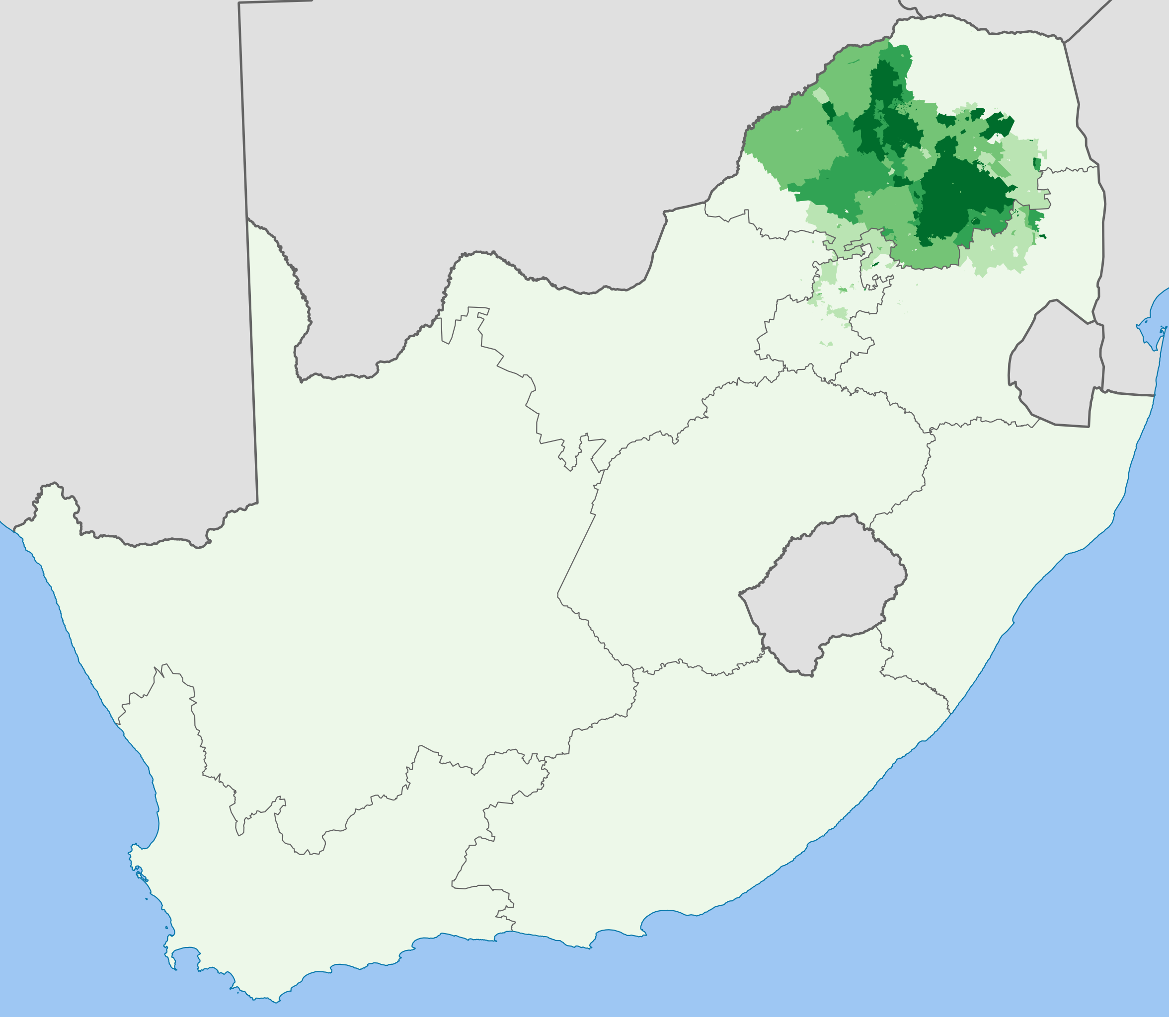
English: Map showing the proportion of the South African population that speaks Sesotho sa Leboa at home, from the 2001 census broken down to "Main Place" level.
0–20%
20–40%
40–60%
60–80%
80–100%
Projection is Albers Equal-Area Conic, with standard parallels at 25.5° S and 31.5° S, and origin at 28.5° S 25.5° E. |
| Datum | |
| Quelle | Statistics South Africa's Census 2001 is the source of the basic population data. The map results from my own processing of the data. |
| Urheber | Htonl |
Lizenz[Bearbeiten]
The following license applies to the population data on which the map is based:

|
Der Urheberrechtsinhaber dieser Datei, Stats SA, erlaubt es jedem, diese für jeden Zweck zu benutzen, vorausgesetzt, dass der Urheberrechtsinhaber ordnungsgemäß genannt wird. Weiterverbreitung, Abänderungen, kommerzielle Nutzung sowie jede andere Verwendung sind gestattet. |
Namensnennung:
"the user acknowledges Stats SA as the source of the basic data wherever they process, apply, utilise, publish or distribute the data, and also that they specify that the relevant application and analysis (where applicable) result from their own processing of the data" [1]
|
The following tag applies to the map itself:
| Ich, der Urheberrechtsinhaber dieses Werkes, veröffentliche es als gemeinfrei. Dies gilt weltweit. In manchen Staaten könnte dies rechtlich nicht möglich sein. Sofern dies der Fall ist: Ich gewähre jedem das bedingungslose Recht, dieses Werk für jedweden Zweck zu nutzen, es sei denn, Bedingungen sind gesetzlich erforderlich. |
Dateiversionen
Klicke auf einen Zeitpunkt, um diese Version zu laden.
| Version vom | Vorschaubild | Maße | Benutzer | Kommentar | |
|---|---|---|---|---|---|
| aktuell | 19:08, 3. Apr. 2012 | | 1.072 × 933 (228 KB) | Htonl (Diskussion | Beiträge) | styles, color handling, color scheme |
| 10:46, 29. Nov. 2010 |  | 1.072 × 933 (634 KB) | Htonl (Diskussion | Beiträge) | remove grey "undefined" areas by drawing from municipal data | |
| 14:05, 2. Okt. 2010 |  | 1.072 × 933 (639 KB) | Htonl (Diskussion | Beiträge) | new approach, smaller filesize | |
| 20:48, 1. Okt. 2010 |  | 1.072 × 933 (2,92 MB) | Htonl (Diskussion | Beiträge) | use equal-area projection | |
| 19:25, 16. Feb. 2010 |  | 1.000 × 786 (2,81 MB) | Htonl (Diskussion | Beiträge) | tweak | |
| 21:47, 6. Feb. 2010 |  | 1.000 × 786 (3,04 MB) | Htonl (Diskussion | Beiträge) | == Summary == {{Information |Description={{en|1=Map showing the proportion of the South African population that speaks Sesotho sa Leboa at home, from the 2001 census broken down to "Main Place" level. {{legend|#eff3ff|0–20%}} {{legend|#bdd7e7|20–40%}} |
Du kannst diese Datei nicht überschreiben.
Dateiverwendung
Keine Seiten verwenden diese Datei.
Globale Dateiverwendung
Die nachfolgenden anderen Wikis verwenden diese Datei:
- Verwendung auf az.wikipedia.org
- Verwendung auf eu.wikipedia.org
- Verwendung auf fi.wikipedia.org
- Verwendung auf xh.wikipedia.org