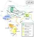
File:South Asia historical AD625 EN.svg
来自Wikimedia Commons
跳转到导航
跳转到搜索

此SVG文件的PNG预览的大小:554 × 600像素。 其他分辨率:222 × 240像素 | 443 × 480像素 | 710 × 768像素 | 946 × 1,024像素 | 1,892 × 2,048像素 | 1,275 × 1,380像素。
原始文件 (SVG文件,尺寸为1,275 × 1,380像素,文件大小:861 KB)
文件信息
结构化数据
说明
说明
添加一行文字以描述该文件所表现的内容
摘要
[编辑]| 描述South Asia historical AD625 EN.svg |
English: Political map of South Asia around 625 AD. The dominant powers were Harsha's Empire in the north, Gauda (Bengal) in the east, and the Chalukyas in the south. The smaller dynasties allied themselves with these: the Maitrakas and Varmans were allied with Harsha against, respectively, the Chalukyas and Gauda. In the extreme south, the Pallavas of Kanchipuram were dominant.
Sources:
|
| 日期 | |
| 来源 | 自己的作品 |
| 作者 | Woudloper |
| 其他版本 |
[编辑]
|
许可协议
[编辑]我,本作品著作权人,特此采用以下许可协议发表本作品:
本文件采用知识共享署名-相同方式共享 4.0 国际许可协议授权。
- 您可以自由地:
- 共享 – 复制、发行并传播本作品
- 修改 – 改编作品
- 惟须遵守下列条件:
- 署名 – 您必须对作品进行署名,提供授权条款的链接,并说明是否对原始内容进行了更改。您可以用任何合理的方式来署名,但不得以任何方式表明许可人认可您或您的使用。
- 相同方式共享 – 如果您再混合、转换或者基于本作品进行创作,您必须以与原先许可协议相同或相兼容的许可协议分发您贡献的作品。
文件历史
点击某个日期/时间查看对应时刻的文件。
| 日期/时间 | 缩略图 | 大小 | 用户 | 备注 | |
|---|---|---|---|---|---|
| 当前 | 2014年8月31日 (日) 04:39 |  | 1,275 × 1,380(861 KB) | Woudloper(留言 | 贡献) | emboldened coast lines |
| 2014年8月31日 (日) 04:21 |  | 1,275 × 1,380(859 KB) | Woudloper(留言 | 贡献) | rendering of orange spot did not work; redrew spot | |
| 2014年8月31日 (日) 04:09 |  | 1,275 × 1,380(859 KB) | Woudloper(留言 | 贡献) | User created page with UploadWizard |
您不可以覆盖此文件。
文件用途
以下10个页面使用本文件:
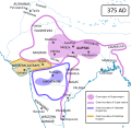
- File:South Asia historical AD375 EN.svg
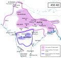
- File:South Asia historical AD450 EN.svg
- File:South Asia historical AD550 EN.svg
- File:South Asia historical AD590 EN.svg
- File:South Asia historical AD625 EN.svg
- File:South Asia historical AD625 NL.svg
- File:South Asia historical AD625 ZH HANS.svg
- File:South Asia historical AD625 ZH HANT.svg
- File:South Asia historical AD625 es.svg
- Template:Other versions/South Asia historical AD625
全域文件用途
以下其他wiki使用此文件:
- ca.wikipedia.org上的用途
- en.wikipedia.org上的用途
- gu.wikipedia.org上的用途
- hi.wikipedia.org上的用途
- id.wikipedia.org上的用途
- lld.wikipedia.org上的用途
- ne.wikipedia.org上的用途
- sq.wikipedia.org上的用途
- ta.wikipedia.org上的用途
- tr.wikipedia.org上的用途
- vi.wikipedia.org上的用途
元数据
此文件含有额外信息,这些信息可能是创建或数字化该文件时使用的数码相机或扫描仪所添加的。如果文件已从其原始状态修改,某些详细信息可能无法完全反映修改后的文件。
| 宽度 | 1275 |
|---|---|
| 高度 | 1380 |


