File:South Island.jpg

元のファイル (2,618 × 2,926 ピクセル、ファイルサイズ: 1.26メガバイト、MIME タイプ: image/jpeg)
キャプション
キャプション
概要[編集]
| 解説 |
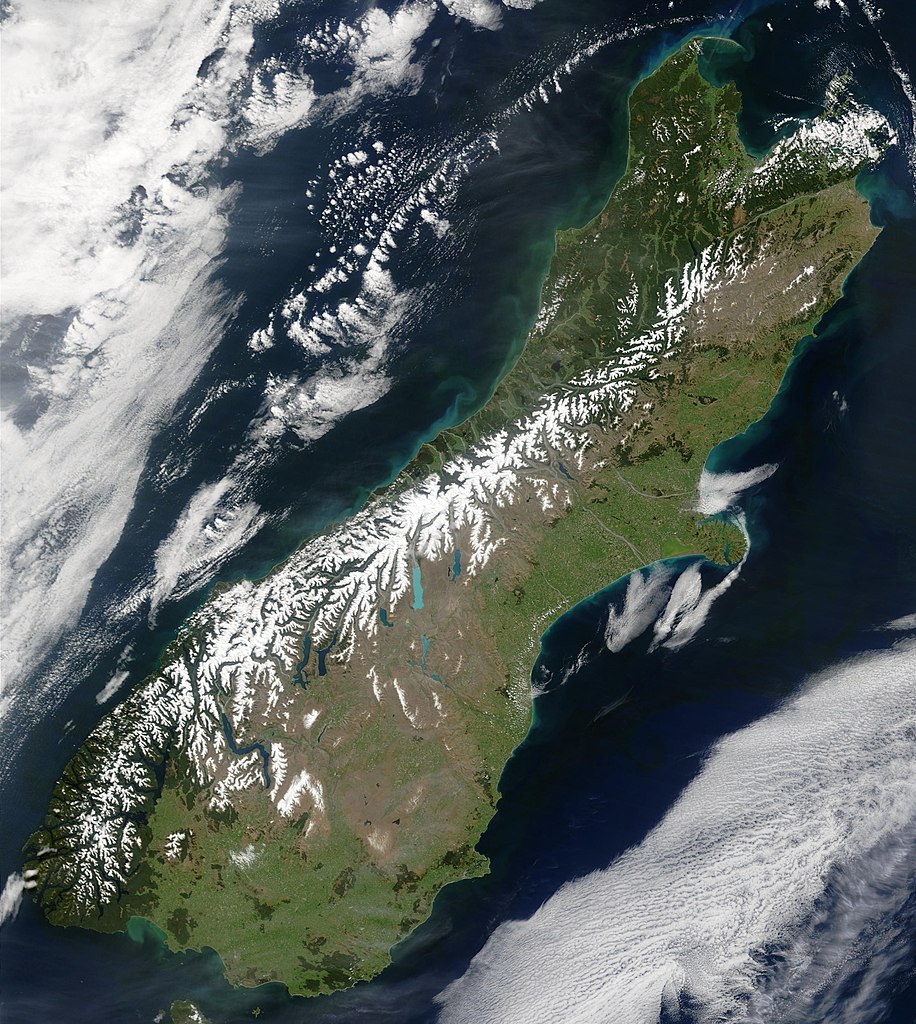
English: This true-color image provides a nearly cloud-free look at the South Island of New Zealand, from NASA’s Terra satellite.
Українська: Сніг виділяє гірські хребти Південних Альп (супутниковий знімок НАСА), Нова Зеландія. |
| 日付 | |
| 原典 | NASA's Earth Observatory |
| 作者 | Jacques Descloitres, MODIS Land Rapid Response Team at NASA GSFC |
| 許可 (ファイルの再利用) |
Public domain - original work of NASA |
| その他のバージョン | Image:South.island.arp.750pix.jpg is lower resolution, more tightly cropped |
This true-color image provides a nearly cloud-free look at the South Island of New Zealand. The scene was acquired by NASA’s Terra satellite, on October 23, 2002.
Forested areas are clearly indicated by the very dark green, particularly in the northwest and southwest. The braided Waimakariri and Rakaia rivers can also clearly be seen as they make their way to the east coast on either side of Banks Peninsula.
Image courtesy Jacques Descloitres, MODIS Land Rapid Response Team at NASA GSFC.
SOURCE: http://earthobservatory.nasa.gov/Newsroom/NewImages/images.php3?img_id=10881
”The purpose of NASA's Earth Observatory is to provide a freely-accessible publication on the Internet where the public can obtain new satellite imagery and scientific information about our home planet. The focus is on Earth's climate and environmental change. In particular, we hope our site is useful to public media and educators. Any and all materials published on the Earth Observatory are freely available for re-publication or re-use, except where copyright is indicated. We ask that NASA's Earth Observatory be given credit for its original materials.”
ライセンス[編集]
| このファイルはアメリカ航空宇宙局(NASA)によって作成されたものです。NASAの著作権の方針では、特記事項が無い場合、NASAの資料はパブリックドメインとなります。 (詳しくはTemplate:PD-USGov、NASAの著作権の方針について(英語)又はジェット推進研究所(JPL)の画像使用に関するガイドライン(英語)をご覧ください。) |
||
 |
注意事項:
|
ファイルの履歴
過去の版のファイルを表示するには、その版の日時をクリックしてください。
| 日付と時刻 | サムネイル | 寸法 | 利用者 | コメント | |
|---|---|---|---|---|---|
| 現在の版 | 2006年5月18日 (木) 00:48 | | 2,618 × 2,926 (1.26メガバイト) | Avenue (トーク | 投稿記録) | {{Information| |Description=This true-color image provides a nearly cloud-free look at the South Island of New Zealand, from NASA’s Terra satellite. |Source=[http://earthobservatory.nasa.gov/Newsroom/NewImages/images.php3?img_id=10881 NASA's Earth Obser |
このファイルは上書きできません。
ファイルの使用状況
このファイルを使用しているページはありません。
グローバルなファイル使用状況
以下に挙げる他のウィキがこの画像を使っています:
- af.wikipedia.org での使用状況
- ang.wikipedia.org での使用状況
- an.wikipedia.org での使用状況
- ar.wikipedia.org での使用状況
- bh.wikipedia.org での使用状況
- ceb.wikipedia.org での使用状況
- cs.wikipedia.org での使用状況
- da.wikipedia.org での使用状況
- de.wikipedia.org での使用状況
- de.wikivoyage.org での使用状況
- el.wikipedia.org での使用状況
- en.wikipedia.org での使用状況
- en.wikiversity.org での使用状況
- eo.wikipedia.org での使用状況
- et.wikipedia.org での使用状況
- fa.wikipedia.org での使用状況
- fi.wikipedia.org での使用状況
- fr.wikipedia.org での使用状況
- gl.wikipedia.org での使用状況
- he.wikipedia.org での使用状況
- hi.wikipedia.org での使用状況
- hr.wikipedia.org での使用状況
- hu.wikipedia.org での使用状況
- is.wikipedia.org での使用状況
- it.wikipedia.org での使用状況
- ja.wikipedia.org での使用状況
- mi.wikipedia.org での使用状況
- mk.wikipedia.org での使用状況
- ml.wikipedia.org での使用状況
- mn.wikipedia.org での使用状況
- nl.wikipedia.org での使用状況
- nn.wikipedia.org での使用状況
- no.wikipedia.org での使用状況
- oc.wikipedia.org での使用状況
- pnb.wikipedia.org での使用状況
- pt.wikipedia.org での使用状況
- sh.wikipedia.org での使用状況
- sk.wikipedia.org での使用状況
- sl.wikipedia.org での使用状況
- sr.wikipedia.org での使用状況
- sv.wikipedia.org での使用状況
- tpi.wikipedia.org での使用状況
- tr.wikipedia.org での使用状況
このファイルのグローバル使用状況を表示する。