File:South Shetland Islands Map.png
Aller à la navigation
Aller à la recherche
Taille de cet aperçu : 800 × 551 pixels. Autres résolutions : 320 × 220 pixels | 640 × 441 pixels | 1 103 × 760 pixels.
Fichier d’origine (1 103 × 760 pixels, taille du fichier : 35 kio, type MIME : image/png)
Légendes
Légendes
Ajoutez en une ligne la description de ce que représente ce fichier
| Description |
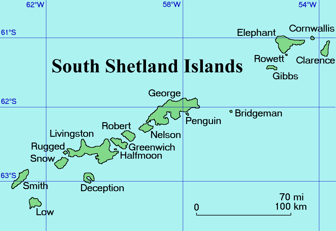
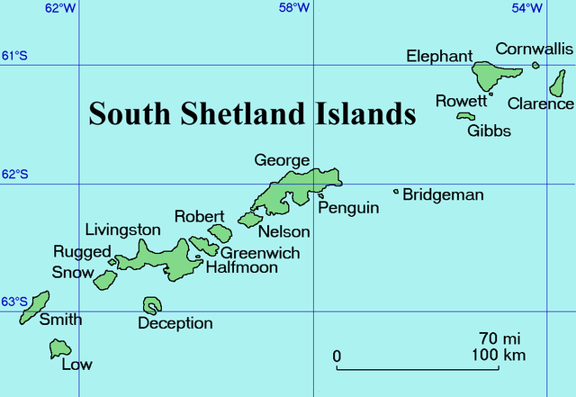
English: Map of the South Shetland Islands
Català: Mapa de les illes Shetland del Sud.
Deutsch: Karte der Südlichen Shetlandinseln
Español: Mapa de las Islas Shetland del Sur
Italiano: Una mappa delle Isole Shetland Meridionali
Русский: Карта Южных Шетландских островов (английский вариант)
Slovenščina: Zemljevid otočja |
| Date | Commons upload by Snowdog |
| Source |
Originally from en.wikipedia; description page is (was) here
|
| Auteur | User Topbanana on en.wikipedia |
| Autorisation (Réutilisation de ce fichier) |
PD-self |
| |
Cette image a été (ou est ici-même) mise à disposition dans le domaine public par son auteur, Topbanana dans le projet Wikimedia Commons. Ceci s'applique partout dans le monde. Au cas où cela n'est pas possible légalement : |
Historique du fichier
Cliquer sur une date et heure pour voir le fichier tel qu'il était à ce moment-là.
| Date et heure | Vignette | Dimensions | Utilisateur | Commentaire | |
|---|---|---|---|---|---|
| actuel | 27 février 2005 à 20:11 | | 1 103 × 760 (35 kio) | Snowdog (d | contributions) | Map of the South Shetland Islands |
Vous ne pouvez pas remplacer ce fichier.
Utilisations locales du fichier
Les 12 pages suivantes utilisent ce fichier :
- Atlas of Antarctica
- Template:South Shetland Islandsyear
- Category:1993 in the South Shetland Islands
- Category:1994 in the South Shetland Islands
- Category:1997 in the South Shetland Islands
- Category:2003 in the South Shetland Islands
- Category:2004 in the South Shetland Islands
- Category:Bridgeman Island
- Category:Maps of the South Shetland Islands
- Category:Mountains of the South Shetland Islands
- Category:Penguin Island (South Shetland Islands)
- Category:South Shetland Islands
Utilisations du fichier sur d’autres wikis
Les autres wikis suivants utilisent ce fichier :
- Utilisation sur af.wikipedia.org
- Utilisation sur ang.wikipedia.org
- Utilisation sur ar.wikipedia.org
- Utilisation sur ast.wikipedia.org
- Utilisation sur az.wikipedia.org
- Utilisation sur ba.wikipedia.org
- Utilisation sur be.wikipedia.org
- Utilisation sur bg.wikipedia.org
- Utilisation sur br.wikipedia.org
- Utilisation sur ca.wikipedia.org
- Utilisation sur ceb.wikipedia.org
- Utilisation sur ce.wikipedia.org
- Utilisation sur cs.wikipedia.org
- Utilisation sur cv.wikipedia.org
- Utilisation sur da.wikipedia.org
- Utilisation sur de.wikipedia.org
- Utilisation sur el.wikipedia.org
- Utilisation sur en.wikipedia.org
- South Shetland Islands
- Gibbs Island (South Shetland Islands)
- Clarence Island (South Shetland Islands)
- Cornwallis Island (South Shetland Islands)
- Seal Islands (South Shetland Islands)
- Benjamin Morrell
- Endurance Point
- Cape Bowles
- Chinstrap Cove
- Walker Point
- Jubilee Peak
- Sultan Glacier
- Furness Glacier
- Gnomon Island
- Cape Lloyd
- Highton Glacier
- Ravelin Ridge
- Cape Valentine
- Wordie Seamount
Voir davantage sur l’utilisation globale de ce fichier.