File:South asia.jpg
跳至導覽
跳至搜尋
無更高解析度可提供。
South_asia.jpg (425 × 533 像素,檔案大小:52 KB,MIME 類型:image/jpeg)
說明
說明
添加單行說明來描述出檔案所代表的內容
摘要[編輯]
| 描述 |
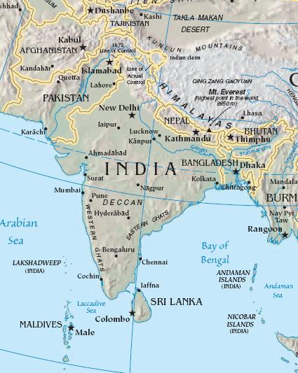
Import from File:South asia.jpg 26 July 2008 English: The image is cropped from en:Image:Sino-Indian Geography.png, created and published by the en:Central Intelligence Agency of the en:United States of America in en:2004.
NoteThis map represents the en:line of control in en:Kashmir as the international border between the en:Republic of India and en:Islamic Republic of Pakistan, a position considered unacceptable to either party. |
| 來源 | CIA World Factbook |
| 作者 | CIA |

|
本圖片是以PNG、GIF或JPEG格式上傳。然而,其中包含的資料或訊息,應該重新建立成可縮放向量圖形(SVG)檔案,以更有效率或更準確的方式儲存。如有可能,請上傳本圖片的SVG格式版本。在上傳之後,請修改維基各姊妹計畫中所有使用舊版圖片的條目(列在圖像連結章節中),替換為新版圖片,並在舊圖片的描述頁中加入{{Vector version available|新圖片名稱.svg}}模板,同時移除本模板。
|


授權條款[編輯]
|
|
 |
原始上傳日誌[編輯]
The original description page was here. All following user names refer to en.wikipedia.
- 2003-10-28 08:22 Mkweise 421×541×8 (88052 bytes) cropped from PD image
檔案歷史
點選日期/時間以檢視該時間的檔案版本。
| 日期/時間 | 縮圖 | 尺寸 | 用戶 | 備註 | |
|---|---|---|---|---|---|
| 目前 | 2008年8月6日 (三) 16:59 | | 425 × 533(52 KB) | Deepak~commonswiki(對話 | 貢獻) | |
| 2008年7月27日 (日) 00:48 |  | 421 × 541(86 KB) | File Upload Bot (Magnus Manske)(對話 | 貢獻) | {{BotMoveToCommons|en.wikipedia}} {{Information |Description={{en|<small>The image is cropped from en::Image:Sino-Indian Geography.png, created and published by the en:Central Intelligence Agency of the en:United States of America in [[:en |
無法覆蓋此檔案。
檔案用途
下列頁面有用到此檔案:
全域檔案使用狀況
以下其他 wiki 使用了這個檔案:
- ace.wikipedia.org 的使用狀況
- ar.wikipedia.org 的使用狀況
- ast.wikipedia.org 的使用狀況
- bg.wikipedia.org 的使用狀況
- bs.wikipedia.org 的使用狀況
- cy.wikipedia.org 的使用狀況
- en.wikipedia.org 的使用狀況
- es.wikipedia.org 的使用狀況
- id.wikipedia.org 的使用狀況
- incubator.wikimedia.org 的使用狀況
- jv.wikipedia.org 的使用狀況
- kn.wikipedia.org 的使用狀況
- la.wikipedia.org 的使用狀況
- ml.wikipedia.org 的使用狀況
- ms.wikipedia.org 的使用狀況
- pam.wikipedia.org 的使用狀況
- pl.wiktionary.org 的使用狀況
- pnb.wikipedia.org 的使用狀況
- rmy.wikipedia.org 的使用狀況
- ru.wikipedia.org 的使用狀況
- sh.wikipedia.org 的使用狀況
- simple.wikipedia.org 的使用狀況
- sr.wikipedia.org 的使用狀況
- sv.wikipedia.org 的使用狀況
- ta.wikipedia.org 的使用狀況
- te.wikipedia.org 的使用狀況
- tl.wikipedia.org 的使用狀況
- tr.wikipedia.org 的使用狀況
- tr.wiktionary.org 的使用狀況
- war.wikipedia.org 的使用狀況
- www.wikidata.org 的使用狀況
- zh.wikipedia.org 的使用狀況
檢視此檔案的更多全域使用狀況。