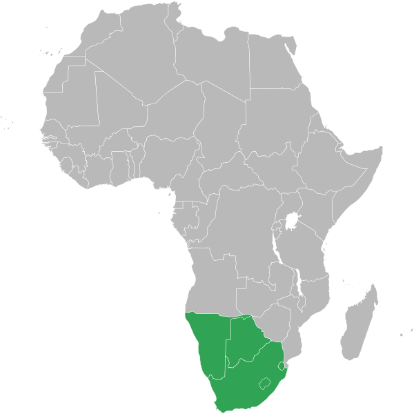
File:Southern African Customs Union.svg
Материал из Викисклада, хранилища свободных медиафайлов
Перейти к навигации
Перейти к поиску

Размер этого PNG-превью для исходного SVG-файла: 600 × 600 пкс. Другие разрешения: 240 × 240 пкс | 480 × 480 пкс | 768 × 768 пкс | 1024 × 1024 пкс | 2048 × 2048 пкс | 1000 × 1000 пкс.
Исходный файл (SVG-файл, номинально 1000 × 1000 пкс, размер файла: 184 КБ)
Сведения о файле
Структурированные данные
Краткие подписи
Краткие подписи
Добавьте однострочное описание того, что собой представляет этот файл
Краткое описание
[править]| ОписаниеSouthern African Customs Union.svg |
English: Map of Africa showing the member nations of the Southern African Customs Union (SACU). |
| Дата | (UTC) |
| Источник | |
| Автор |
|
Лицензирование
[править]| Public domainPublic domainfalsefalse |
| Я, владелец авторских прав на это произведение, передаю его в общественное достояние. Это разрешение действует по всему миру. В некоторых странах это не может быть возможно юридически, в таком случае: Я даю право кому угодно использовать данное произведение в любых целях без каких-либо условий, за исключением таких условий, которые требуются по закону. |
Исходный журнал загрузок
[править]This image is a derivative work of the following images:
- File:BlankMap-Africa.svg licensed with PD-user
- 2011-11-08T13:50:11Z Htonl 1000x1000 (188219 Bytes) South Sudan has been allocated ISO code SS; change class and id correspondingly
- 2011-07-09T21:38:33Z Lokal Profil 1000x1000 (188235 Bytes) Fixed code. Essentialy reverted and readded south sudan manually
- 2011-07-09T17:09:06Z Seb az86556 1000x1000 (189357 Bytes) +South Sudan
- 2010-07-18T16:04:42Z Stephen Morley 1000x1000 (189216 Bytes) Fixed errors that made SVG invalid
- 2009-09-22T16:22:54Z Lokal Profil 1000x1000 (188987 Bytes) Reverted to version as of 00:54, 3 April 2008; the new map contains none of the iso code and css abilities of the original
- 2009-09-22T15:11:08Z NuclearVacuum 1000x1000 (360040 Bytes) minor change
- 2009-09-22T15:06:20Z NuclearVacuum 1000x1000 (360239 Bytes) Fixed map so it shows surrounding countries as well as making the code valid
- 2008-04-03T00:54:00Z Lokal Profil 1000x1000 (188987 Bytes) reunion, saint helena, madeira and canary islands (mayotte already in) added for completion
- 2008-04-01T00:21:58Z Lokal Profil 1000x1000 (185868 Bytes) Made circles smaller, and circular. They were the right size for the world map but to big for the Africa only map
- 2008-03-31T23:55:20Z Lokal Profil 1000x1000 (185877 Bytes) Removed circle for gambia, not needed for Africa only map
- 2008-03-24T03:09:01Z Lokal Profil 1000x1000 (186084 Bytes) {{Information |Description=Blank map of Africa Detailed SVG map with grouping enabled to connect all non-contiguous parts of a country's territory for easy colouring. Smaller countries can also be represented by larger circl
Uploaded with derivativeFX
История файла
Нажмите на дату/время, чтобы увидеть версию файла от того времени.
| Дата/время | Миниатюра | Размеры | Участник | Примечание | |
|---|---|---|---|---|---|
| текущий | 13:33, 20 ноября 2011 |  | 1000 × 1000 (184 КБ) | Htonl (обсуждение | вклад) | == {{int:filedesc}} == {{Information |Description=Map of Africa showing the member nations of the w:Southern African Customs Union (SACU). |Source=*File:BlankMap-Africa.svg |Date=2011-11-20 13:32 (UTC) |Author=*File:BlankMap-Africa.svg: [ |
Вы не можете перезаписать этот файл.
Использование файла
Следующая страница использует этот файл:
Глобальное использование файла
Данный файл используется в следующих вики:
- Использование в af.wikipedia.org
- Использование в ar.wikipedia.org
- Использование в ast.wikipedia.org
- Использование в bn.wikipedia.org
- Использование в de.wikipedia.org
- Использование в el.wikipedia.org
- Использование в en.wikipedia.org
- Использование в id.wikipedia.org
- Использование в ka.wikipedia.org
- Использование в pl.wikipedia.org
- Использование в pt.wikipedia.org
- Использование в ru.wikipedia.org
- Использование в si.wikipedia.org
- Использование в sn.wikipedia.org
- Использование в te.wikipedia.org
- Использование в vi.wikipedia.org
- Использование в www.wikidata.org
- Использование в zh.wikipedia.org