File:Southern British Isles 9th century.svg
跳至導覽
跳至搜尋

此 SVG 檔案的 PNG 預覽的大小:629 × 435 像素。 其他解析度:320 × 221 像素 | 640 × 443 像素 | 1,024 × 708 像素 | 1,280 × 885 像素 | 2,560 × 1,770 像素。
原始檔案 (SVG 檔案,表面大小:629 × 435 像素,檔案大小:1.95 MB)
說明
說明
添加單行說明來描述出檔案所代表的內容
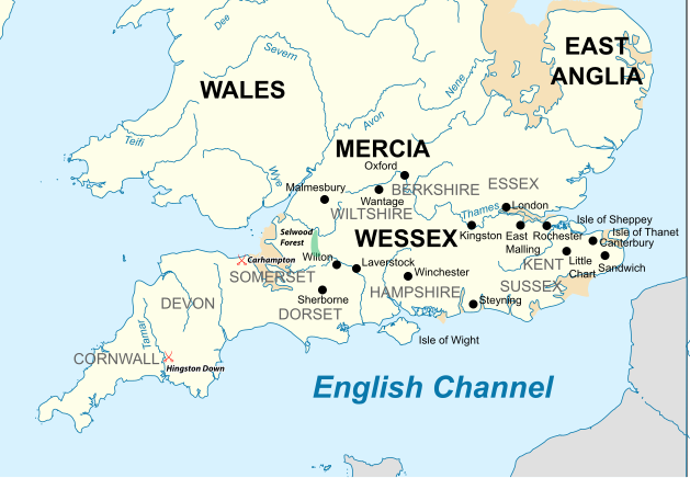
Map of the Southern British Isles during the 9th century
| 描述 |
English: Map of the Southern British Isles during the 9th century |
| 日期 | |
| 來源 | 自己的作品 Incorporates elements of this map. Locations are based on the Ordinance Survey Atlas of Great Britain, apart from Selwood Forest, which is taken from Barbara Yorke, Wessex in the Early Middle Ages, 1995, p. 23, ISBN 0 7185 1856 X |
| 作者 | Philg88; Attribution: Wikimedia Foundation (www.wikimedia.org) |
| 授權許可 (重用此檔案) |
W3C-validity not checked. 本向量圖形使用Adobe Illustrator創作。 此檔案採用創用CC 姓名標示 4.0 國際授權條款。
|
檔案歷史
點選日期/時間以檢視該時間的檔案版本。
| 日期/時間 | 縮圖 | 尺寸 | 用戶 | 備註 | |
|---|---|---|---|---|---|
| 目前 | 2015年7月19日 (日) 17:30 | | 629 × 435(1.95 MB) | Philg88(對話 | 貢獻) | User requested modifications |
| 2015年7月19日 (日) 16:00 |  | 629 × 435(1.65 MB) | Philg88(對話 | 貢獻) | {{Information |Description ={{en|1=Map of the Southern British Isles during the 9th century}} |Source ={{own}} Incorporates elements of [https://commons.wikimedia.org/wiki/File:British_Isles_10th_century.svg this map] |Author =[[User... |
無法覆蓋此檔案。
檔案用途
沒有使用此檔案的頁面。
全域檔案使用狀況
以下其他 wiki 使用了這個檔案:
- bn.wikipedia.org 的使用狀況
- br.wikipedia.org 的使用狀況
- cs.wikipedia.org 的使用狀況
- el.wikipedia.org 的使用狀況
- en.wikipedia.org 的使用狀況
- es.wikipedia.org 的使用狀況
- fa.wikipedia.org 的使用狀況
- he.wikipedia.org 的使用狀況
- ja.wikipedia.org 的使用狀況
- ko.wikipedia.org 的使用狀況
- ms.wikipedia.org 的使用狀況
- sk.wikipedia.org 的使用狀況
- th.wikipedia.org 的使用狀況
- tr.wikipedia.org 的使用狀況
- zh.wikipedia.org 的使用狀況