File:St. John, U.S. Virgin Islands.jpg
Pumunta sa nabigasyon
Pumunta sa paghahanap

Laki ng pasilip na ito: 600 x 600 na pixel. Ibang resolusyon: 240 x 240 na pixel | 480 x 480 na pixel | 768 x 768 na pixel | 1,024 x 1,024 na pixel | 2,400 x 2,400 na pixel.
Orihinal na file (2,400 × 2,400 na pixel, laki: 2.74 MB, uri ng MIME: image/jpeg)
Captions
Captions
Add a one-line explanation of what this file represents
Buod
[baguhin]| Paglalarawan |
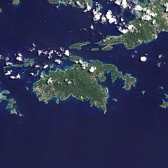
English: Natural-colour image of the Island of St. John island in the United States Virgin Islands.
|
| Petsa | |
| Pinanggalingan | NASA Earth Observatory |
| May-akda | Jesse Allen and Robert Simmon |
| Iba pang mga bersyon |


.jpg)

Image captured by the Advanced Land Imager (ALI) on NASA’s Earth Observing-1 (EO-1) satellite. EO-1 ALI data provided courtesy of the NASA EO-1 team.
Paglilisensiya
[baguhin]
| This file is in the public domain in the United States because it was solely created by NASA. NASA copyright policy states that "NASA material is not protected by copyright unless noted". (See Template:PD-USGov, NASA copyright policy page or JPL Image Use Policy.) | ||
 |
Warnings:
|
| Annotations | This image is annotated: View the annotations at Commons |
Nakaraan ng file
Pindutin ang isang petsa/oras para makita ang file noong puntong yon.
| Petsa/Oras | Thumbnail | Sukat | Tagagamit | Komento | |
|---|---|---|---|---|---|
| ngayon | 10:13, 20 Enero 2011 | | 2,400 × 2,400 (2.74 MB) | Originalwana (usapan | ambag) | {{Information |Description={{en|1=Natural-colour image of the eastern half of St. John. Settlements—marked by curving roads and light roofs—line the irregular coastline. The pinpoints of white in Coral Bay are probably boats. The island’s interior |
Hindi mo mao-overwrite ang file na ito.
Paggamit sa file
Lagpas sa 100 pahina ang gumagamit sa file na ito. Ipinapakita lang ng talaan sa baba ang unang pahina na gumagamit sa file na ito. May buong talaan ding magagamit.
- United States Virgin Islands
- File:E part of St. John, Booby Rock, Leduck Island, Flanagan Island, Watermelon Cay, U.S. Virgin Islands.jpg
- File:Grass Cay, Mingo Cay, Lovango Cay, Congo Cay, Carval Rock, Rata Cay, Henley Cay, Ramgoat Cay, Turtle Bay beach, U.S. Virgin Islands.jpg
- File:W end of St. Thomas, Great-, Little Saint James, Dog Island, Steven Cay, W part of St. John, U.S. Virgin Islands (cropped).jpg
- File:W end of St. Thomas, Great-, Little Saint James, Dog Island, U.S. Virgin Islands.jpg
- File:Watermelon Cay next to N coast of St. John, U.S. Virgin Islands.jpg
- Category:1948 in the United States Virgin Islands
- Category:1976 in the United States Virgin Islands
- Category:1979 in the United States Virgin Islands
- Category:1988 in the United States Virgin Islands
- Category:1992 in the United States Virgin Islands
- Category:1994 in the United States Virgin Islands
- Category:1995 in the United States Virgin Islands
- Category:1998 in the United States Virgin Islands
- Category:2002 in the United States Virgin Islands
- Category:2003 in the United States Virgin Islands
- Category:2004 in the United States Virgin Islands
- Category:2005 in the United States Virgin Islands
- Category:2006 in the United States Virgin Islands
- Category:2007 in the United States Virgin Islands
- Category:2008 in the United States Virgin Islands
- Category:2009 in the United States Virgin Islands
- Category:2010 in the United States Virgin Islands
- Category:2011 in the United States Virgin Islands
- Category:2012 in the United States Virgin Islands
- Category:2013 in the United States Virgin Islands
- Category:2014 in the United States Virgin Islands
- Category:2015 in the United States Virgin Islands
- Category:2016 in the United States Virgin Islands
- Category:2017 in the United States Virgin Islands
- Category:2020 in the United States Virgin Islands
- Category:2022 in the United States Virgin Islands
- Category:Airlines of the United States Virgin Islands
- Category:Airports in the United States Virgin Islands
- Category:Archaeological sites in the United States Virgin Islands
- Category:Athletics competitors from the United States Virgin Islands
- Category:Aviation in the United States Virgin Islands
- Category:Baseball in the United States Virgin Islands
- Category:Bays of the United States Virgin Islands
- Category:Beaches of the United States Virgin Islands
- Category:Beauty pageants in the United States Virgin Islands
- Category:Birds of the United States Virgin Islands
- Category:Births in the United States Virgin Islands
- Category:Bodies of water in the United States Virgin Islands
- Category:Botanical gardens in the United States Virgin Islands
- Category:Buildings in the United States Virgin Islands
- Category:Cathedrals in the United States Virgin Islands
- Category:Churches in the United States Virgin Islands
- Category:Congressional districts of the United States Virgin Islands
- Category:Culture of the United States Virgin Islands
- Category:Deaths in the United States Virgin Islands
- Category:Education in the United States Virgin Islands
- Category:Entertainment events in the United States Virgin Islands
- Category:Events in the United States Virgin Islands
- Category:Flora of the United States Virgin Islands
- Category:Forts in the United States Virgin Islands
- Category:Gardens in the United States Virgin Islands
- Category:Government buildings in the United States Virgin Islands
- Category:Government of the United States Virgin Islands
- Category:Higher education institutions in the United States Virgin Islands
- Category:Historic American Buildings Survey of the United States Virgin Islands
- Category:Historic American Engineering Record images of the United States Virgin Islands
- Category:Historic districts in the United States Virgin Islands
- Category:History of the United States Virgin Islands by period
- Category:International airports in the United States Virgin Islands
- Category:Islands of the United States Virgin Islands
- Category:Landforms of the United States Virgin Islands
- Category:Maps of the United States Virgin Islands
- Category:Military in the United States Virgin Islands
- Category:National Historic Landmarks in the United States Virgin Islands
- Category:National Register of Historic Places in the United States Virgin Islands
- Category:Nature of the United States Virgin Islands
- Category:Observatories in the United States Virgin Islands
- Category:Olympic lugers from the United States Virgin Islands
- Category:Olympic silver medalists for the United States Virgin Islands
- Category:Olympic sportspeople from the United States Virgin Islands
- Category:Parks in the United States Virgin Islands
- Category:People of the United States Virgin Islands by occupation
- Category:Plantations in the United States Virgin Islands
- Category:Politicians of the United States Virgin Islands
- Category:Populated places in the United States Virgin Islands
- Category:Protected areas of the United States Virgin Islands
- Category:Roman Catholic churches in the United States Virgin Islands
- Category:Saint John, United States Virgin Islands
- Category:Schools in the United States Virgin Islands
- Category:Science in the United States Virgin Islands
- Category:Society of the United States Virgin Islands
- Category:Sports in the United States Virgin Islands
- Category:Sports in the United States Virgin Islands by sport
- Category:Sportspeople from the United States Virgin Islands
- Category:Sprinters from the United States Virgin Islands
- Category:Synagogues in the United States Virgin Islands
- Category:Templates related to the United States Virgin Islands
- Category:Tourism in the United States Virgin Islands
- Category:United States Virgin Islands
- Category:United States Virgin Islands by year
- Category:United States Virgin Islands in the 2000s
- Category:United States Virgin Islands in the 2010s
- Category:United States Virgin Islands in the 20th century
- Category:United States Virgin Islands in the 21st century
Tingnan ang mas marami pang mga kawing para sa pahinang ito.
Pandaigdigang paggamit sa file
Ginagamit ng mga sumusunod na wiki ang file na ito:
- Paggamit sa arz.wikipedia.org
- Paggamit sa ast.wikipedia.org
- Paggamit sa ca.wikipedia.org
- Paggamit sa ceb.wikipedia.org
- Paggamit sa cy.wikipedia.org
- Paggamit sa de.wikivoyage.org
- Paggamit sa en.wikipedia.org
- Paggamit sa en.wikisource.org
- Paggamit sa eo.wikipedia.org
- Paggamit sa es.wikipedia.org
- Paggamit sa eu.wikipedia.org
- Paggamit sa fi.wikipedia.org
- Paggamit sa frr.wikipedia.org
- Paggamit sa fr.wikivoyage.org
- Paggamit sa gl.wikipedia.org
- Paggamit sa id.wikipedia.org
- Paggamit sa lb.wikipedia.org
- Paggamit sa pl.wikipedia.org
- Paggamit sa tg.wikipedia.org
- Paggamit sa tl.wikipedia.org
- Paggamit sa uk.wikipedia.org
- Paggamit sa vec.wikipedia.org
- Paggamit sa www.wikidata.org