File:Stalingrad - Preparations for Operation Uranus.png
Aller à la navigation
Aller à la recherche
Taille de cet aperçu : 800 × 492 pixels. Autres résolutions : 320 × 197 pixels | 640 × 394 pixels | 1 024 × 630 pixels | 1 280 × 788 pixels | 2 560 × 1 576 pixels | 4 321 × 2 660 pixels.
Fichier d’origine (4 321 × 2 660 pixels, taille du fichier : 2,83 Mio, type MIME : image/png)
Légendes
Légendes
Ajoutez en une ligne la description de ce que représente ce fichier

|
Cette image (de type carte) devrait être recréée dans un format vectoriel, en tant que fichier SVG. Cela offrirait plusieurs avantages : voir Commons:Media for cleanup pour plus d'informations. Si une version SVG de cette image est déjà disponible, merci de bien vouloir l'envoyer. Après cela, remplacez ce modèle par {{vector version available|nouveau nom d'image.svg}}.
|
Description[modifier]
| Description |
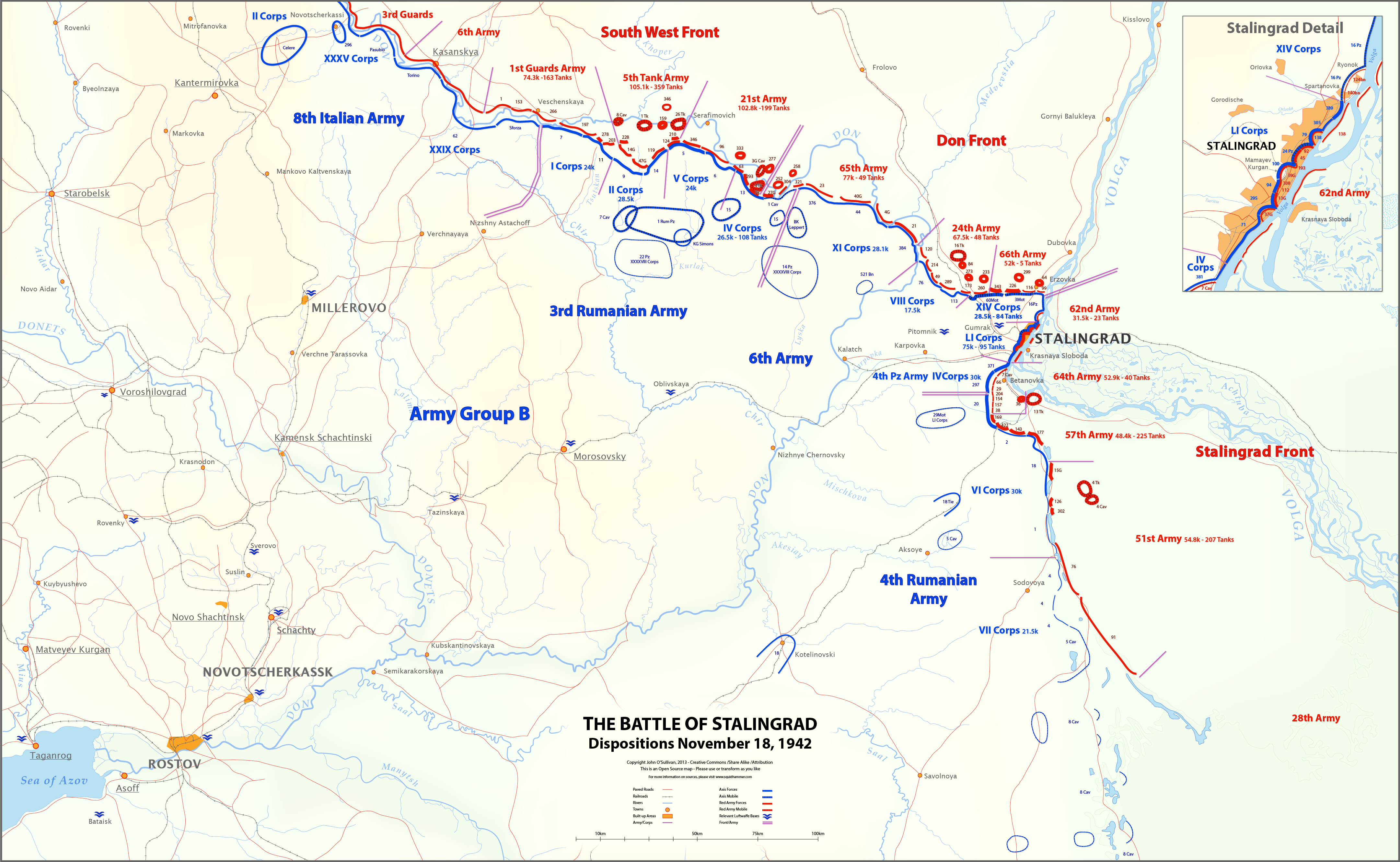
English: This map shows unit locations and relative strengths for Axis and Soviet Armies on Nov 18, 1942, during the Battle of Stalingrad.
On November 19, the Soviets launched Operation Uranus, an offensive designed to isolate and destroy the German 6th Army at Stalingrad. |
| Date | |
| Source | Travail personnel |
| Auteur | Josullivan.59 |
| Autres versions |
 |
Sources:
Books and Articles
| Author | Title | Notes |
| Alexei V. Isaev | Stalingrad: The Volga No Land For Us | Soviet forces and tanks |
| Antony Beevor | Stalingrad-The-Fateful-Siege-1942-1943 | Most widely cited Order of Battle |
| Wikipedia | Red Army Order of Battle Stalingrad | Useful |
| Wikipedia | Axis order of battle at the Battle of Stalingrad | Not particularly useful |
| Staldata | Staldata | Axis and Soviet Orders of Battle & force strength |
| Wolf Höpper | Against the Flood - Operation Uranus (I) | German tank numbers |
| Joel S. A. Hayward | Stopped At Stalingrad: The Luftwaffe And Hitler's Defeat In The East 1942-1943 | Bases used for Airlift |
| Akhil Kadidal | Stalingrad Pocket | Really good maps and annotated photographs |
Maps
| Title | Source | Notes |
| OKH Situation Map Nov 18 42 | WW2 Photos Maps | Axis forces locations Fantastic Site! |
| OKH Situation Map Nov 18 42 2 | WW2 Photos Maps | Axis forces locations Fantastic Site! |
| S4231 Summary of combat operations in Stalingrad | Armchair General/RIIAWW2 | Red Army locations Excellent map |
| S4239 Operations in Stalingrad area | RIIAWW2 Armchair General/RIIAWW2 | Red Army locations |
| S4251 Combat operations of the South-Western, Don and Stalingrad Fronts | Armchair General/RIIAWW2 | Red Army locations |
Notes:
- My Order of Battle is here.
- There are more units listed in the Order of Battle than appear on the map. I didn't place any unit on the map unless I could find it in one of the source maps.
- In conflicts between locations on the OKH map and the Soviet maps, I used the Soviet map. The Germans had not picked up the Uranus build-up, so the Soviets had much better intelligence at this time.
- I could find no information on the strength of the 8th Italian Army, or Soviet 6th and 3rd Guards Armies.
- Unit lines are thicker or thinner based on strength and density. These are characterizations, not precise measurements.
- Unit strengths are shown in the layers in the SVG version of the map. These are based on the Order of Battle spreadsheet linked above. The spreadsheet includes notes on the units shown on the map.
- The base map is derived from the OKH maps. I do not know the map projection.
- Please feel free to comment on any inaccuracies! You can help to make the map better. I'm particularly interested in proper place-names.
- Vous êtes libre :
- de partager – de copier, distribuer et transmettre cette œuvre
- d’adapter – de modifier cette œuvre
- Sous les conditions suivantes :
- paternité – Vous devez donner les informations appropriées concernant l'auteur, fournir un lien vers la licence et indiquer si des modifications ont été faites. Vous pouvez faire cela par tout moyen raisonnable, mais en aucune façon suggérant que l’auteur vous soutient ou approuve l’utilisation que vous en faites.
- partage à l’identique – Si vous modifiez, transformez, ou vous basez sur cette œuvre, vous devez distribuer votre contribution sous la même licence ou une licence compatible avec celle de l’original.
Conditions d’utilisation[modifier]
Moi, en tant que détenteur des droits d’auteur sur cette œuvre, je la publie sous la licence suivante :
Ce fichier est disponible selon les termes de la licence Creative Commons Attribution – Partage dans les Mêmes Conditions 3.0 (non transposée).
Historique du fichier
Cliquer sur une date et heure pour voir le fichier tel qu'il était à ce moment-là.
| Date et heure | Vignette | Dimensions | Utilisateur | Commentaire | |
|---|---|---|---|---|---|
| actuel | 12 mars 2013 à 18:27 | | 4 321 × 2 660 (2,83 Mio) | Josullivan.59 (d | contributions) | Fixed the licensing information on the map. |
| 12 mars 2013 à 18:13 |  | 4 322 × 2 660 (3,89 Mio) | Josullivan.59 (d | contributions) | User created page with UploadWizard |
Vous ne pouvez pas remplacer ce fichier.
Utilisations locales du fichier
Aucune page n’utilise ce fichier.
Utilisations du fichier sur d’autres wikis
Les autres wikis suivants utilisent ce fichier :
- Utilisation sur de.wikipedia.org
- Utilisation sur en.wikipedia.org
- Utilisation sur es.wikipedia.org
- Utilisation sur fi.wikipedia.org
- Utilisation sur fr.wikipedia.org
- Utilisation sur ja.wikipedia.org
- Utilisation sur no.wikipedia.org
- Utilisation sur pt.wikipedia.org
- Utilisation sur uk.wikipedia.org