File:Statehood quarters map 2009.svg
跳至導覽
跳至搜尋

此 SVG 檔案的 PNG 預覽的大小:800 × 495 像素。 其他解析度:320 × 198 像素 | 640 × 396 像素 | 1,024 × 633 像素 | 1,280 × 791 像素 | 2,560 × 1,583 像素 | 959 × 593 像素。
原始檔案 (SVG 檔案,表面大小:959 × 593 像素,檔案大小:113 KB)
說明
說明
添加單行說明來描述出檔案所代表的內容
摘要[編輯]
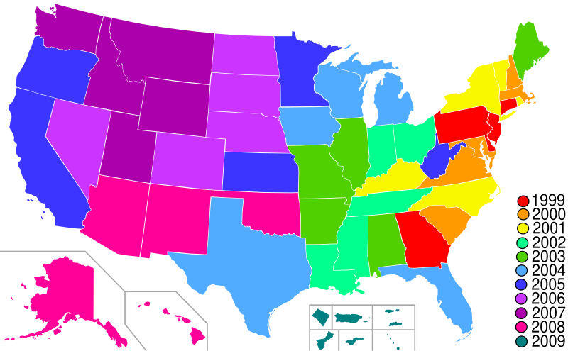
| 描述 | Map of Statehood quarters with the 2009 issues |
| 日期 | |
| 來源 | base map is Lokal_Profil's blank map of US with territories; color scheme and the key is from the png version of this map by me. Guam has been redone based on Image:Guam-CIA WFB Map.png. American Samoa has been added based on Image:American Samoa-CIA WFB Map.png |
| 作者 | Hoshie |
授權條款[編輯]
我,本作品的著作權持有者,決定用以下授權條款發佈本作品:

|
已授權您依據自由軟體基金會發行的無固定段落、封面文字和封底文字GNU自由文件授權條款1.2版或任意後續版本,對本檔進行複製、傳播和/或修改。該協議的副本列在GNU自由文件授權條款中。 |
| 此檔案採用創用CC 姓名標示-相同方式分享 3.0 未在地化版本授權條款。 | ||
| ||
| 已新增授權條款標題至此檔案,作為GFDL授權更新的一部份。 |
檔案歷史
點選日期/時間以檢視該時間的檔案版本。
| 日期/時間 | 縮圖 | 尺寸 | 使用者 | 備註 | |
|---|---|---|---|---|---|
| 目前 | 2009年1月30日 (五) 02:28 | | 959 × 593(113 KB) | Hoshie(留言 | 貢獻) | move DC inset to the bottom with the others |
| 2009年1月18日 (日) 23:33 |  | 959 × 593(112 KB) | Hoshie(留言 | 貢獻) | Made DC an inset; fixed Tutuila (American Samoa) | |
| 2009年1月13日 (二) 05:08 |  | 959 × 593(112 KB) | Hoshie(留言 | 貢獻) | {{Information |Description=Map of Statehood quarters with the 2009 issues |Source=base map is Lokal_Profil's blank map of US with territories; color scheme and the key is from the [[:Image:Stat |
無法覆蓋此檔案。
檔案用途
下列頁面有用到此檔案:
全域檔案使用狀況
以下其他 wiki 使用了這個檔案:
- ar.wikipedia.org 的使用狀況
- de.wikipedia.org 的使用狀況
- en.wikipedia.org 的使用狀況
- es.wikipedia.org 的使用狀況
- fr.wikipedia.org 的使用狀況
- gl.wikipedia.org 的使用狀況
- it.wikipedia.org 的使用狀況
- ja.wikipedia.org 的使用狀況
- ko.wikipedia.org 的使用狀況
- nl.wikipedia.org 的使用狀況
- ru.wikipedia.org 的使用狀況
- uk.wikipedia.org 的使用狀況
- zh.wikipedia.org 的使用狀況