File:Stone-Young-Baggett House.jpg

Originaldatei (671 × 902 Pixel, Dateigröße: 375 KB, MIME-Typ: image/jpeg)
Bildtexte
Kurzbeschreibungen
|
Dieses Bild zeigt ein Objekt, das im National Register of Historic Places der Vereinigten Staaten verzeichnet ist. Die Referenznummer lautet 1001411. |
Beschreibung
[Bearbeiten]| Beschreibung |
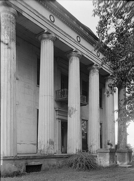
English: Stone-Young-Baggett House, County Road 54 (Old Selma Road), Montgomery, Montgomery County, AL. CLOSE-UP FRONT ELEVATION (NORTH). |
||||||
| Datum | |||||||
| Quelle | Historic American Buildings Survey,Library of Congress, Prints & Photographs Division, HABS [or HAER or HALS], Reproduction number "HABS ALA,51-MONG.V,1-8" | ||||||
| Urheber | Alex Bush, Photographer | ||||||
| Genehmigung (Weiternutzung dieser Datei) |
|
||||||
| Andere Versionen | http://hdl.loc.gov/loc.pnp/hhh.al0665 | ||||||

| Objektposition | | Dieses und weitere Bilder auf OpenStreetMap |
|---|

|
Diese Datei stammt aus Historic American Buildings Survey (HABS), Historic American Engineering Record (HAER) or Historic American Landscapes Survey (HALS). Dies sind Programme des National Park Service, die zum Zweck der Dokumentation historischer Orte eingerichtet wurden. Die Aufzeichnungen bestehen aus gemessenen Zeichnungen, Archivfotos und schriftlichen Berichten.
|
| Diese Datei ist ein Werk eines Mitarbeiters des National Park Service (NPS) der Vereinigten Staaten, aufgenommen oder hergestellt während seiner offiziellen Anstellung. Als ein amtliches Werk der Bundesregierung der Vereinigten Staaten ist dieses Bild gemeinfrei. (Nähere Informationen dazu sind auf der offiziellen Website des NPS verfügbar.) |
Dateiversionen
Klicke auf einen Zeitpunkt, um diese Version zu laden.
| Version vom | Vorschaubild | Maße | Benutzer | Kommentar | |
|---|---|---|---|---|---|
| aktuell | 04:36, 12. Feb. 2008 | | 671 × 902 (375 KB) | Altairisfar (Diskussion | Beiträge) | == Summary == {{Information |Description={{en|Stone-Young-Baggett House, County Road 54 (Old Selma Road), Montgomery, Montgomery County, AL. CLOSE-UP FRONT ELEVATION (NORTH).}} |Source=Historic American Buildings Survey,Library of Congress, Prints & Phot |
Du kannst diese Datei nicht überschreiben.
Dateiverwendung
Die folgende Seite verwendet diese Datei:
Globale Dateiverwendung
Die nachfolgenden anderen Wikis verwenden diese Datei:
- Verwendung auf de.wikipedia.org
- Verwendung auf en.wikipedia.org
- National Register of Historic Places listings in Montgomery County, Alabama
- Ebenezer Missionary Baptist Church (Auburn, Alabama)
- Bessemer Hall of History
- Twickenham Historic District
- Five Points Historic District (Huntsville, Alabama)
- Florida Underwater Archaeological Preserve
- Cotaco Opera House
- Byler Road
- Grace Episcopal Church (Clayton, Alabama)
- Old Shelby County Courthouse
- St. Paul's Episcopal Church (Magnolia Springs, Alabama)
- Grace Episcopal Church (Anniston, Alabama)
- St. Michael and All Angels Episcopal Church (Anniston, Alabama)
- Jefferson Historic District (Jefferson, Alabama)
- Demopolis Historic Business District
- Demopolis Town Square
- Curtis House (Demopolis, Alabama)
- Church Street East Historic District
- Old Dauphin Way Historic District
- Oakleigh Garden Historic District
- Lower Dauphin Street Historic District
- Leinkauf Historic District
- Ashland Place Historic District (Mobile, Alabama)
- Campground Historic District
- De Tonti Square Historic District
- Midtown Historic District (Mobile, Alabama)
- Mobile City Hospital
- Carlen House
- Monterey Place
- Template:Alabama-NRHP-stub
- Washington Firehouse No. 5
- Petty–Roberts–Beatty House
- Beal–Gaillard House
- Carolina Hall
- Collins–Robinson House
- Martin Horst House
- Saint Paul's Episcopal Chapel (Mobile, Alabama)
- Sodality Chapel
- South Lafayette Street Creole Cottages
- St. Francis Street Methodist Church
- Stewartfield (Mobile, Alabama)
- Wade Askew House
- George Levy House
- Ernest Megginson House
- J. E. Paterson House
- Arthur VanderSys House
- Jacob VanderSys House
- Joseph M. Walker House
- George Fearn House
Weitere globale Verwendungen dieser Datei anschauen.