File:Strait of Dover map.png
跳转到导航
跳转到搜索

本预览的尺寸:798 × 599像素。 其他分辨率:320 × 240像素 | 639 × 480像素 | 1,000 × 751像素。
原始文件 (1,000 × 751像素,文件大小:187 KB,MIME类型:image/png)
说明
说明
添加一行文字以描述该文件所表现的内容
Map outlining Northern France, low countries & Southern England with Europe location pop-out
摘要
[编辑]| 描述 |
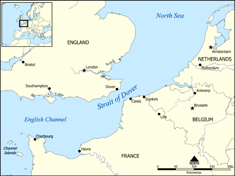
This map shows the location of the Strait of Dover between England and France, and part of the English Channel and the North Sea. It also shows nearby towns such as Dover, Calais, and Dunkirk. Created by NormanEinstein, December 15, 2005. |
| 日期 | 2005年12月15日 (原始上传日期) |
| 来源 | No machine-readable source provided. Own work assumed (based on copyright claims). |
| 作者 | No machine-readable author provided. NormanEinstein assumed (based on copyright claims). |
许可协议
[编辑]我,本作品著作权人,特此采用以下许可协议发表本作品:

|
已授权您依据自由软件基金会发行的无固定段落及封面封底文字(Invariant Sections, Front-Cover Texts, and Back-Cover Texts)的GNU自由文件许可协议1.2版或任意后续版本的条款,复制、传播和/或修改本文件。该协议的副本请见“GNU Free Documentation License”。 |
| 本文件采用知识共享署名-相同方式共享 3.0 未本地化版本许可协议授权。 | ||
| ||
| 本许可协议标签作为GFDL许可协议更新的组成部分被添加至本文件。 |
您可以选择您需要的许可协议。
Derivative works
[编辑]-
 hrvatski (SVG)
 -
 македонски (SVG)
 -
 English (PNG), showing evacuation routes of the Dunkirk evacuation


| 注解 | 该图片含有注解:在维基媒体共享资源上查看注解 |
文件历史
点击某个日期/时间查看对应时刻的文件。
| 日期/时间 | 缩略图 | 大小 | 用户 | 备注 | |
|---|---|---|---|---|---|
| 当前 | 2014年6月13日 (五) 19:17 | | 1,000 × 751(187 KB) | Hohum(留言 | 贡献) | Adjust colours |
| 2005年12月15日 (四) 15:34 |  | 1,000 × 751(296 KB) | NormanEinstein(留言 | 贡献) | This map shows the location of the Strait of Dover between England and France, and part of the English Channel and the North Sea. It also shows nearby towns such as Dover, Calais, and Dunkirk. Created by NormanEinstein, December 15, 2005. {{GFDL-self}} |
您不可以覆盖此文件。
文件用途
以下3个页面使用本文件:
全域文件用途
以下其他wiki使用此文件:
- af.wikipedia.org上的用途
- an.wikipedia.org上的用途
- ar.wikipedia.org上的用途
- ba.wikipedia.org上的用途
- be-tarask.wikipedia.org上的用途
- be.wikipedia.org上的用途
- bg.wikipedia.org上的用途
- bh.wikipedia.org上的用途
- bn.wikipedia.org上的用途
- br.wikipedia.org上的用途
- da.wikipedia.org上的用途
- de.wikipedia.org上的用途
- el.wikipedia.org上的用途
- en.wikipedia.org上的用途
- en.wikibooks.org上的用途
- fa.wikipedia.org上的用途
- fi.wikipedia.org上的用途
- fr.wikipedia.org上的用途
- fy.wikipedia.org上的用途
- gl.wikipedia.org上的用途
- hu.wikipedia.org上的用途
- id.wikipedia.org上的用途
- it.wikipedia.org上的用途
- ja.wikipedia.org上的用途
- la.wikipedia.org上的用途
- mr.wikipedia.org上的用途
- ms.wikipedia.org上的用途
- nn.wikipedia.org上的用途
- no.wikipedia.org上的用途
- pt.wikipedia.org上的用途
- ro.wikipedia.org上的用途
- simple.wikipedia.org上的用途
查看此文件的更多全域用途。