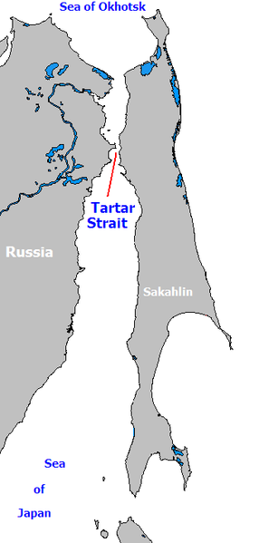
File:Strait of Tartary.PNG
Ji Wikimedia Commons
Here nagîvasyonê
Here lêgerînê

Mezinahiya vê pêşdîtinê: 286 × 599 pîksel. Resolusyonên din: 114 × 240 pîksel | 340 × 712 pîksel.
Dosyeya orjînal (340 × 712 pixel, mezinbûnê data: 17 KB, MIME-typ: image/png)
File information
Structured data
Captions
Captions
Add a one-line explanation of what this file represents

|
This map image could be re-created using vector graphics as an SVG file. This has several advantages; see Commons:Media for cleanup for more information. If an SVG form of this image is available, please upload it and afterwards replace this template with
{{vector version available|new image name}}.
It is recommended to name the SVG file “Strait of Tartary.svg”—then the template Vector version available (or Vva) does not need the new image name parameter. |
The Strait of Tartary connects the Sea of Okhostsk to the Sea of Japan.
| Public domainPublic domainfalsefalse |
| This work has been released into the public domain by its author, WikiDon. This applies worldwide. In some countries this may not be legally possible; if so: |
Dîroka daneyê
Ji bo dîtina guhartoya wê demê bişkoka dîrokê bitikîne.
| Dîrok/Katjimêr | Wêneyê biçûk | Mezinahî | Bikarhêner | Şirove | |
|---|---|---|---|---|---|
| niha | 09:06, 5 adar 2008 |  | 340 x 712 (17 KB) | Shack (gotûbêj | beşdarî) | The Strait of Tartary connects the Sea of Okhostsk to the Sea of Japan. {{PD-User|WikiDon|en}} Category:Straits |
Tu nikarî cardin li ser vê dosyeyê binivîsînî.
Bikaranîna pelê
Rûpelekî ku ji vê dosyeyê bi kar tîne nîne.
Bikaranîna gerdûnî ya pelê
Ev wîkiyên di rêzê de vê pelê bi kar tînin:
- Bikaranîna di af.wikipedia.org de
- Bikaranîna di ar.wikipedia.org de
- Bikaranîna di bg.wikipedia.org de
- Bikaranîna di da.wikipedia.org de
- Bikaranîna di el.wikipedia.org de
- Bikaranîna di en.wikipedia.org de
- Bikaranîna di es.wikipedia.org de
- Bikaranîna di fa.wikipedia.org de
- Bikaranîna di fi.wikipedia.org de
- Bikaranîna di fr.wikipedia.org de
- Bikaranîna di gl.wikipedia.org de
- Bikaranîna di it.wikipedia.org de
- Bikaranîna di km.wikipedia.org de
- Bikaranîna di ko.wikipedia.org de
- Bikaranîna di ku.wikipedia.org de
- Bikaranîna di nn.wikipedia.org de
- Bikaranîna di ro.wikipedia.org de
- Bikaranîna di simple.wikipedia.org de
- Bikaranîna di sr.wikipedia.org de
- Bikaranîna di te.wikipedia.org de
- Bikaranîna di tr.wikipedia.org de
- Bikaranîna di vi.wikipedia.org de
- Bikaranîna di zh-yue.wikipedia.org de
- Bikaranîna di zh.wikipedia.org de