File:Subcarpathia Carpatho-Ukraine.svg
跳转到导航
跳转到搜索

此SVG文件的PNG预览的大小:688 × 525像素。 其他分辨率:315 × 240像素 | 629 × 480像素 | 1,007 × 768像素 | 1,280 × 977像素 | 2,560 × 1,953像素。
原始文件 (SVG文件,尺寸为688 × 525像素,文件大小:105 KB)
说明
说明
添加一行文字以描述该文件所表现的内容
摘要[编辑]
| 描述 |
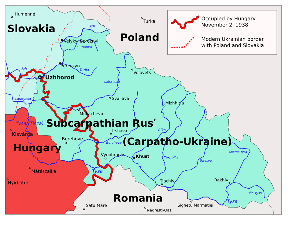
English: Map of the Subcarpathian Rus (1919-1938), that was an autonomous region of the first Czechoslovak Republic; later transformed into the Carpathian Ukraine (1938-1939), that was an autonomous region of the second Czechoslovak Republic, and briefly a self-proclaimed independent state, in March 1939. Own work based on different printed and digital maps.
Polski: Zakarpacie w latach 1938–1939. |
| 日期 | 2006年3月22日 (原始上传日期) |
| 来源 | 无法识别来源。根据版权声明推断为其自己的作品。 |
| 作者 | 无法识别作者。根据版权声明推断作者为PM。 |
| 其他版本 |
|


derivative works[编辑]
Derivative works of this file:
- Subcarpathia Carpatho-Ukraine uk.svg
- Subcarpathia Carpatho-Ukraine-es.svg
- Subcarpathia Carpatho-Ukraine be.svg
- Carpatho Ukraine March 1939.png
许可协议[编辑]
| 我,本作品著作权人,释出本作品至公有领域。这适用于全世界。 在一些国家这可能不合法;如果是这样的话,那么: 我无条件地授予任何人以任何目的使用本作品的权利,除非这些条件是法律规定所必需的。 |
文件历史
点击某个日期/时间查看对应时刻的文件。
| 日期/时间 | 缩略图 | 大小 | 用户 | 备注 | |
|---|---|---|---|---|---|
| 当前 | 2020年11月22日 (日) 23:40 | | 688 × 525(105 KB) | Mzajac(留言 | 贡献) | copy-edit per sources |
| 2020年11月22日 (日) 23:35 |  | 688 × 525(105 KB) | Mzajac(留言 | 贡献) | Copy edit per sources | |
| 2020年11月22日 (日) 22:30 |  | 688 × 525(105 KB) | Mzajac(留言 | 贡献) | File uploaded using svgtranslate tool (https://svgtranslate.toolforge.org/). Added translation for en. | |
| 2009年11月2日 (一) 09:24 |  | 688 × 525(81 KB) | Malarz pl(留言 | 贡献) | display fix | |
| 2006年3月22日 (三) 00:24 |  | 688 × 525(89 KB) | PM(留言 | 贡献) | ||
| 2006年3月22日 (三) 00:16 |  | 688 × 525(89 KB) | PM(留言 | 贡献) | Autonomous Subcarpathian Ruthenia and independent Carpatho-Ukraine 1938-1939. Own work based on different printed and digital maps. Category:Maps of Ukraine |
您不可以覆盖此文件。
文件用途
以下9个页面使用本文件:
- User:Magog the Ogre/Multilingual legend/2020 November 21-30
- File:Podkarpatská Rus.png
- File:Subcarpathia Carpatho-Ukraine-es.svg
- File:Subcarpathia Carpatho-Ukraine-hu.svg
- File:Subcarpathia Carpatho-Ukraine be.svg
- File:Subcarpathia Carpatho-Ukraine german.svg
- File:Subcarpathia Carpatho-Ukraine uk.svg
- File:Подкарпатская Русь (1939).svg
- Template:Other versions/Subcarpathia Carpatho-Ukraine
.svg)
全域文件用途
以下其他wiki使用此文件:
- bg.wikipedia.org上的用途
- de.wikipedia.org上的用途
- en.wikipedia.org上的用途
- eo.wikipedia.org上的用途
- fa.wikipedia.org上的用途
- fi.wikipedia.org上的用途
- fr.wikipedia.org上的用途
- hy.wikipedia.org上的用途
- it.wikipedia.org上的用途
- ka.wikipedia.org上的用途
- nl.wikipedia.org上的用途
- no.wikipedia.org上的用途
- pl.wikipedia.org上的用途
- Użhorod
- Karpato-Ukraina
- Ukraina Karpacka
- Zakarpacie
- Obwód zakarpacki
- Dyskusja wikipedysty:P
- Granica polsko-węgierska
- Dyskusja wikipedysty:Malarz pl/Archiwum/9
- Operacja Łom
- Wikipedysta:Malarz pl/szablony/Państwo stary szablon infobox/10
- Wikipedysta:Malarz pl/szablony/Państwo stary szablon infobox
- Wikipedysta:PanGawelek/Rozbiory Czechosłowacji
- pt.wikipedia.org上的用途
- ro.wikipedia.org上的用途
- ru.wikipedia.org上的用途
- sh.wikipedia.org上的用途
- sl.wikipedia.org上的用途
- sr.wikipedia.org上的用途
- uk.wikipedia.org上的用途
- Користувач:Alex Blokha/Дні згадані в Вікіпедії/Україна/22 листопада
- Користувач:Alex Blokha/Дні згадані в Вікіпедії/Україна/22 січня
- Користувач:Alex Blokha/Дні згадані в Вікіпедії/Україна/15 березня
- Користувач:Alex Blokha/Дні згадані в Вікіпедії/Україна/18 березня
- Користувач:Alex Blokha/Дні згадані в Вікіпедії/Україна/4 квітня
- Користувач:Alex Blokha/Дні згадані в Вікіпедії/Україна/29 червня
- Лом (операція)
- Польсько-угорський кордон
- vi.wikipedia.org上的用途
- www.wikidata.org上的用途
- zh.wikipedia.org上的用途