File:Suez Canal traffic jam seen from space.jpg
原始檔案 (1,920 × 1,141 像素,檔案大小:1.8 MB,MIME 類型:image/jpeg)
說明
說明
摘要
[編輯]
| 描述 |
Español: Bloqueo del Canal de Suez causado por el barco Ever Given visto por el satélite Sentinel-1.
English: The enormous Ever Given container ship, wedged in Egypt’s Suez Canal, is visible in new images captured by the Copernicus Sentinel-1 mission.
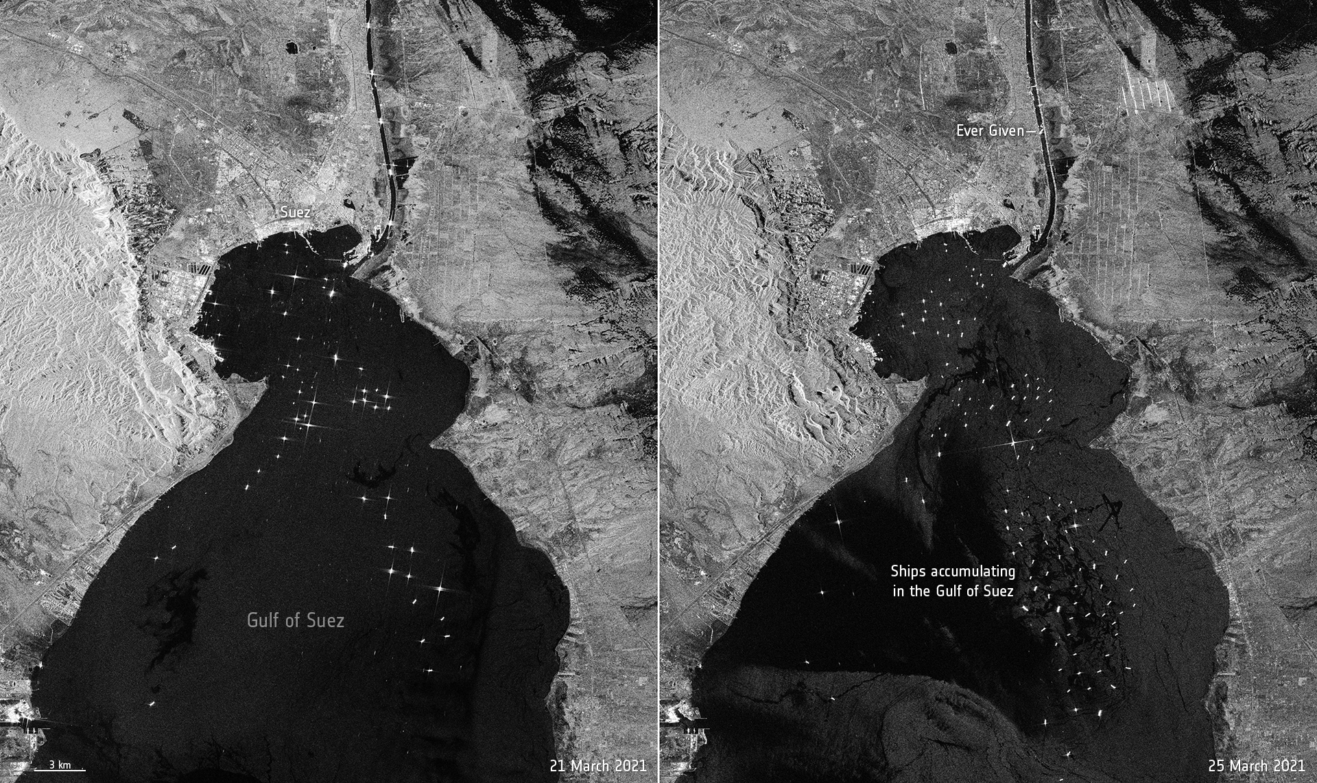
The giant container ship ran aground in the canal on 23 March on its journey from China to the Netherlands. The image on the left, captured on 21 March, shows routine maritime traffic in the canal with vessels visible every 2 to 3 km. The image on the right, captured on 25 March, shows the 400 m-ship blocking the canal. The canal connects Port Said on the Mediterranean Sea to the Indian Ocean via the Egyptian city of Suez on the Red Sea. The blockage has delayed hundreds of tankers and vessels in reaching their destination, and more maritime traffic is still heading to the crucial waterway. Ships can be seen accumulating in the Gulf of Suez. Tug boats are working hard to dislodge the 200 000 tonne ship, however Egyptian authorities say it is unclear when the route will reopen. The two identical Copernicus Sentinel-1 satellites carry radar instruments to provide an all-weather, day-and-night supply of imagery of Earth’s surface, making it ideal to monitor ship traffic. The sea surface reflects the radar signal away from the satellite, and makes water appear dark in the image. This contrasts with metal objects, in this case the ships in the bay, which appear as bright dots in the dark waters. |
| 日期 | |
| 來源 | https://www.esa.int/ESA_Multimedia/Images/2021/03/Suez_Canal_traffic_jam_seen_from_space |
| 作者 | European Space Agency |
授權條款
[編輯]

|
此图像包含来自哥白尼计划中的卫星的数据,例如哨兵1号、哨兵2号或哨兵3号。使用此图片时需要注明出处。
姓名標示: 包含修改后的哥白尼哨兵数据2021
哥白尼哨兵数据的使用受欧盟法律监管(委员会授权条例 (EU) No 1159/2013和条例 (EU) No 377/2014)。相关摘录:
应免费访问通过GMES传播平台提供的GMES专用数据[...]。
在合法的范围内应出于以下用途的目的访问GMES专用数据[...]:
GMES专用数据[...]可在全球范围内不受时间限制地使用。
向用户提供GMES专用数据和GMES服务信息没有任何明示或暗示的保证,包括关于质量和任何目的的适用性。 |
This media was created by the European Space Agency (ESA).
Where expressly so stated, images or videos are covered by the Creative Commons Attribution-ShareAlike 3.0 IGO (CC BY-SA 3.0 IGO) licence, ESA being an Intergovernmental Organisation (IGO), as defined by the CC BY-SA 3.0 IGO licence. The user is allowed under the terms and conditions of the CC BY-SA 3.0 IGO license to Reproduce, Distribute and Publicly Perform the ESA images and videos released under CC BY-SA 3.0 IGO licence and the Adaptations thereof, without further explicit permission being necessary, for as long as the user complies with the conditions and restrictions set forth in the CC BY-SA 3.0 IGO licence, these including that:
See the ESA Creative Commons copyright notice for complete information, and this article for additional details.
|
 | |
此檔案採用創用CC 姓名標示-相同方式分享 3.0 國際政府組織授權條款。 姓名標示: ESA, CC BY-SA IGO 3.0
| ||
檔案歷史
點選日期/時間以檢視該時間的檔案版本。
| 日期/時間 | 縮圖 | 尺寸 | 用戶 | 備註 | |
|---|---|---|---|---|---|
| 目前 | 2021年3月26日 (五) 14:37 | | 1,920 × 1,141(1.8 MB) | BugWarp(對話 | 貢獻) | Uploaded a work by European Space Agency from https://www.esa.int/ESA_Multimedia/Images/2021/03/Suez_Canal_traffic_jam_seen_from_space with UploadWizard |
無法覆蓋此檔案。
檔案用途
下列2個頁面有用到此檔案:
.jpg&redirect=no)
全域檔案使用狀況
以下其他 wiki 使用了這個檔案:
- ar.wikipedia.org 的使用狀況
- ca.wikipedia.org 的使用狀況
- es.wikipedia.org 的使用狀況
- eu.wikipedia.org 的使用狀況
- fa.wikipedia.org 的使用狀況
- fr.wikipedia.org 的使用狀況
- he.wikipedia.org 的使用狀況
- it.wikipedia.org 的使用狀況
- ja.wikipedia.org 的使用狀況
- ko.wikipedia.org 的使用狀況
- pl.wikipedia.org 的使用狀況
- ru.wikipedia.org 的使用狀況
- simple.wikipedia.org 的使用狀況
- sv.wikipedia.org 的使用狀況
- ta.wikipedia.org 的使用狀況
- tr.wikipedia.org 的使用狀況
- uk.wikipedia.org 的使用狀況
- vi.wikipedia.org 的使用狀況
- www.wikidata.org 的使用狀況
- zh.wikipedia.org 的使用狀況