File:SundaIslands.A2003242.0225.500m.jpg
跳转到导航
跳转到搜索

本预览的尺寸:776 × 600像素。 其他分辨率:311 × 240像素 | 621 × 480像素 | 994 × 768像素 | 1,280 × 989像素 | 2,200 × 1,700像素。
原始文件 (2,200 × 1,700像素,文件大小:600 KB,MIME类型:image/jpeg)
说明
说明
添加一行文字以描述该文件所表现的内容
摘要[编辑]
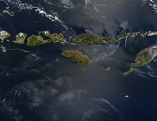
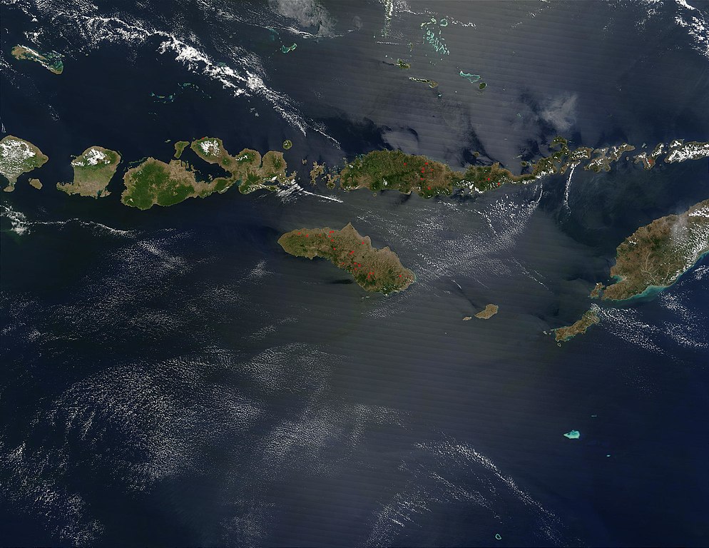
| 描述 | The Lesser Sunda Islands, Indonesia Forming the southern arc of central Indonesia, the Lesser Sunda Islands link the island of Java (west) to the island of Timor (east). The islands stretch 1,200 kilometers west to east, and traverse the waters of the Timor, Sawu, Banda, and Flores Seas, as well as the Indian Ocean. Dotted across the islands are a number of fires, which are marked in bright red. Two tiny islands in this chain, Komodo and Rinca, are famous for being the home of dragons —of the non-mythical variety. Komodo Dragons are four-legged monitor lizards that are extremely fierce. They can weigh up to 130 kg (287 lbs) and grow to be over 3 meters (about 10 feet) in length. Komodo Dragons are a protected species, with only about 5700 of them living on these two and other smaller local islands. Komodo, Rinca, and Padar Islands (as well as numerous smaller islands) are part of Komodo National Park, which was established in 1980, and which was declared a World Heritage Site in 1991. Komodo Island is located just to the west of Flores Island, which is the long thin island dotted with numerous fires in the upper center of the image. This true-color Terra MODIS image was acquired on August 30, 2003. |
| 日期 | |
| 来源 | http://visibleearth.nasa.gov/view_rec.php?id=5819 |
| 作者 | NASA |
| 其他版本 |
|

.jpg)
许可协议[编辑]
| 本文件完全由NASA创作,在美国属于公有领域。根据NASA的版权方针,NASA的材料除非另有声明否则不受版权保护。(参见Template:PD-USGov/zh、NASA版权方针页面或JPL图片使用方针。) | ||
 |
警告:
|
文件历史
点击某个日期/时间查看对应时刻的文件。
| 日期/时间 | 缩略图 | 大小 | 用户 | 备注 | |
|---|---|---|---|---|---|
| 当前 | 2005年10月26日 (三) 03:46 | | 2,200 × 1,700(600 KB) | Brian0918(留言 | 贡献) | The Lesser Sunda Islands, Indonesia Forming the southern arc of central Indonesia, the Lesser Sunda Islands link the island of Java (west) to the island of Timor (east). The islands stretch 1,200 kilometers west to east, and traverse the waters of the Ti |
您不可以覆盖此文件。
文件用途
以下3个页面使用本文件:
全域文件用途
以下其他wiki使用此文件:
- af.wikipedia.org上的用途
- ar.wikipedia.org上的用途
- ast.wikipedia.org上的用途
- az.wikipedia.org上的用途
- ba.wikipedia.org上的用途
- be.wikipedia.org上的用途
- bs.wikipedia.org上的用途
- ca.wikipedia.org上的用途
- ceb.wikipedia.org上的用途
- cs.wikipedia.org上的用途
- cy.wikipedia.org上的用途
- da.wikipedia.org上的用途
- de.wikipedia.org上的用途
- el.wikipedia.org上的用途
- en.wikipedia.org上的用途
- eo.wikipedia.org上的用途
- es.wikipedia.org上的用途
- fa.wikipedia.org上的用途
- fi.wikipedia.org上的用途
- fi.wiktionary.org上的用途
- fr.wikipedia.org上的用途
- fr.wikivoyage.org上的用途
- gl.wikipedia.org上的用途
- he.wikipedia.org上的用途
- hr.wikipedia.org上的用途
- hsb.wikipedia.org上的用途
- hu.wikipedia.org上的用途
- id.wikipedia.org上的用途
- ilo.wikipedia.org上的用途
- it.wikipedia.org上的用途
- ja.wikipedia.org上的用途
- jv.wikipedia.org上的用途
- ka.wikipedia.org上的用途
- ko.wikipedia.org上的用途
查看此文件的更多全域用途。