File:Syrian, Iraqi, and Lebanese insurgencies.png
Zur Navigation springen
Zur Suche springen

Größe dieser Vorschau: 784 × 600 Pixel. Weitere Auflösungen: 314 × 240 Pixel | 628 × 480 Pixel | 1.004 × 768 Pixel | 1.280 × 979 Pixel | 2.560 × 1.958 Pixel | 4.509 × 3.449 Pixel.
Originaldatei (4.509 × 3.449 Pixel, Dateigröße: 1,74 MB, MIME-Typ: image/png)
Bildtexte
Kurzbeschreibungen
Ergänze eine einzeilige Erklärung, was diese Datei darstellt.
Beschreibung

|
Diese Datei könnte aktualisiert werden, um neue Informationen zu berücksichtigen. Falls die Verwendung einer bestimmten, nicht aktualisierten Version der Datei gewünscht wird, sollte die gewünschte Version separat hochgeladen werden. |
| Beschreibung |
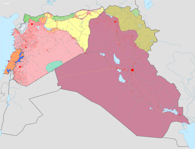
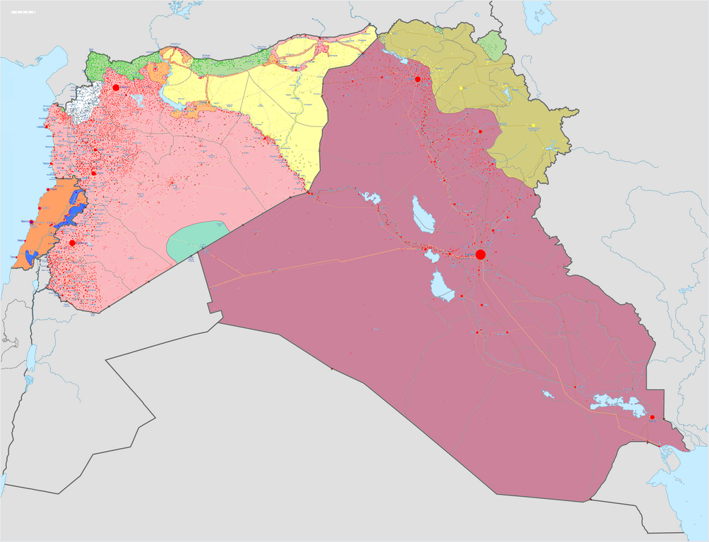
Karte des Bürgerkriegs in Syrien und des Aufstands im Irak Kontrolliert von der syrischen Regierung
Kontrolliert von der irakischen Regierung
Kontrolliert von der libanesischen Regierung
Kontrolliert von der Hisbollah
Kontrolliert vom Islamischen Staat (IS)
Kontrolliert von der Front für die Eroberung der Levante (ehemals al-Nusra-Front)
Kontrolliert von syrischen Kurden
Kontrolliert von irakischen Kurden
legend needs updating |
||||
| Datum | |||||
| Quelle |
Eigenes Werk w:en:Template:Syrian, Iraqi, and Lebanese insurgencies detailed map |
||||
| Urheber | BlueHypercane761 | ||||
| Andere Versionen |
|


.png)


.svg)


.svg)

.svg)


_Territory_Change_2014-2016.gif)

_(within_Northern_Syria).svg)


.png)
.svg)


_map.png)
.svg)


.svg)


|
Dieses Bild des Typs Historical map sollte als Vektorgrafik im SVG-Format neu erstellt werden. Vektorformate haben zahlreiche Vorteile; weitere Information unter Commons:Media for cleanup. Wenn dir eine SVG-Version dieses Bildes vorliegt, so lade diese bitte hoch. Nach dem Hochladen der Datei ist diese Vorlage auf der aktuellen Bildbeschreibungsseite durch die Vorlage {{Vector version available}}, oder kürzer {{Vva}}, zu ersetzen. Es ist empfohlen die neue SVG-Datei „Syrian, Iraqi, and Lebanese insurgencies.svg“ zu nennen – dann benötigt die Vorlage vector version available (bzw. vva) keinen Parameter.
|

|
This image has a useful history, which can be viewed as an animation. |
Lizenz
Ich, der Urheber dieses Werkes, veröffentliche es unter der folgenden Lizenz:
Diese Datei ist lizenziert unter der Creative-Commons-Lizenz „Namensnennung – Weitergabe unter gleichen Bedingungen 4.0 international“.
- Dieses Werk darf von dir
- verbreitet werden – vervielfältigt, verbreitet und öffentlich zugänglich gemacht werden
- neu zusammengestellt werden – abgewandelt und bearbeitet werden
- Zu den folgenden Bedingungen:
- Namensnennung – Du musst angemessene Urheber- und Rechteangaben machen, einen Link zur Lizenz beifügen und angeben, ob Änderungen vorgenommen wurden. Diese Angaben dürfen in jeder angemessenen Art und Weise gemacht werden, allerdings nicht so, dass der Eindruck entsteht, der Lizenzgeber unterstütze gerade dich oder deine Nutzung besonders.
- Weitergabe unter gleichen Bedingungen – Wenn du das Material wiedermischst, transformierst oder darauf aufbaust, musst du deine Beiträge unter der gleichen oder einer kompatiblen Lizenz wie das Original verbreiten.
Dateiversionen
Klicke auf einen Zeitpunkt, um diese Version zu laden.
| Version vom | Vorschaubild | Maße | Benutzer | Kommentar | |
|---|---|---|---|---|---|
| aktuell | 11:43, 6. Sep. 2020 | | 4.509 × 3.449 (1,74 MB) | LyriaSiders (Diskussion | Beiträge) | Reports that the SAA have taken over the Doubayat oil and gas field and surrounding area from ISIL elements. Now there is apparently no more hard control by ISIL in the central desert. |
| 15:10, 24. Mai 2020 |  | 4.509 × 3.449 (2,21 MB) | Wiz9999 (Diskussion | Beiträge) | Updating Revolutionary Commando Army & US presence colour to teal. | |
| 11:27, 7. Mär. 2020 |  | 4.509 × 3.449 (1,74 MB) | Nate Hooper (Diskussion | Beiträge) | Update after the Turkish response. Also, see the discussion page for a further update I have planned. | |
| 03:23, 19. Feb. 2020 |  | 4.509 × 3.449 (1,75 MB) | Nate Hooper (Diskussion | Beiträge) | Update after the Idlib offensive. | |
| 23:45, 7. Feb. 2020 |  | 4.509 × 3.449 (1,75 MB) | The Dolly Parton Challenge - Still more country than Alan Jackson (Diskussion | Beiträge) | Further SAA advances towards Idlib. | |
| 23:26, 7. Feb. 2020 |  | 4.509 × 3.449 (2,51 MB) | The Dolly Parton Challenge - Still more country than Alan Jackson (Diskussion | Beiträge) | Reverted to version as of 00:25, 6 February 2020 (UTC) Never mind | |
| 00:32, 6. Feb. 2020 |  | 4.509 × 3.449 (2,51 MB) | TheHatingNerdino666 (Diskussion | Beiträge) | Fixed the Manbij area. | |
| 00:25, 6. Feb. 2020 |  | 4.509 × 3.449 (2,51 MB) | TheHatingNerdino666 (Diskussion | Beiträge) | Big update as the Syrian Army continues the push towards Idlib. | |
| 17:05, 7. Jan. 2020 |  | 4.509 × 3.449 (2,27 MB) | Nate Hooper (Diskussion | Beiträge) | Wew, it's been a while (I was a way for a bit because I was banned, but I appealed and was successful). Anyway, the SAA have made advances in Idlib. | |
| 17:05, 27. Okt. 2019 |  | 4.509 × 3.449 (2,51 MB) | Mlpwtfisthat Backup 7.0 (Diskussion | Beiträge) | Remove the date. |
Du kannst diese Datei nicht überschreiben.
Dateiverwendung
Mehr als 100 Seiten verwenden diese Datei. Die folgende Liste zeigt nur die ersten 100 Verwendungen dieser Datei. Eine vollständige Liste ist verfügbar.
- User:Hermes79
- User:Hermes7979
- User:Magog the Ogre/Maps of conflicts/2015 August
- User:Magog the Ogre/Maps of conflicts/2015 December
- User:Magog the Ogre/Maps of conflicts/2015 July
- User:Magog the Ogre/Maps of conflicts/2015 June
- User:Magog the Ogre/Maps of conflicts/2015 November
- User:Magog the Ogre/Maps of conflicts/2015 October
- User:Magog the Ogre/Maps of conflicts/2015 September
- User:Magog the Ogre/Maps of conflicts/2016 April
- User:Magog the Ogre/Maps of conflicts/2016 August
- User:Magog the Ogre/Maps of conflicts/2016 February
- User:Magog the Ogre/Maps of conflicts/2016 January
- User:Magog the Ogre/Maps of conflicts/2016 July
- User:Magog the Ogre/Maps of conflicts/2016 June
- User:Magog the Ogre/Maps of conflicts/2016 March
- User:Magog the Ogre/Maps of conflicts/2016 May
- User:Magog the Ogre/Maps of conflicts/2016 November
- User:Magog the Ogre/Maps of conflicts/2016 October
- User:Magog the Ogre/Maps of conflicts/2016 September
- User:RobiH
- User talk:BlueHypercane761
- File:2013 Hama Offensive.svg
- File:2015 Latakia Frontlines.svg
- File:26032019Syrian, Iraqi, and Lebanese insurgencies.png (Dateiweiterleitung)
- File:Aleppo Offensives 2015.svg
- File:Aleppo offensive (October 2013).svg
- File:Attaques-terroristes-meurtrières-au-21eme-siecle.png
- File:Battle of Daraa City.svg
- File:Battle of Hasakah.svg
- File:Battle of Qamishli.svg
- File:Battle of Raqqa.svg
- File:Battle of Tadmur.svg
- File:Battle of Western Qalamoun.svg
- File:Battlefields in The Global War on Terror.svg
- File:Battlefields in The Global War on Terror - edit03.png
- File:Battlefields in The Global War on Terror - edit04.png
- File:Benghazi Conflict Detailed Map.png
- File:Benghazi Conflict Detailed Map.svg
- File:Boko Haram insurgency map.svg
- File:Countries by soldier count.svg
- File:Deir ez-Zor clashes (2017).svg
- File:Derna Conflict Detailed Map.png
- File:East Congo conflict map.svg
- File:GSPC map.png
- File:ISIS (Grey) Territory Change 2014-2016.gif
- File:Iraqi Civil War map (2014–present).png
- File:Islamist insurgency in Nigeria.svg
- File:Lebanese insurgency.svg
- File:Libyan Civil War.svg
- File:Libyan war final-fr.svg
- File:Map of Ongoing conflicts around the world.png
- File:Map of terror of the Islamic State (ad-Daula al-islāmiyya).png
- File:Mexico states map small war.PNG
- File:Mosul offensive (2015) map.png
- File:Number of Terrorist Incidents.png
- File:Ongoing Conflicts (1).png
- File:Pakistan-Waziristan-Map.png
- File:Political map Afar triangle.png
- File:Rif Damashq.svg
- File:Siege of Homs Map.svg
- File:Sinai insurgency.svg
- File:SituationSyriaIraqLebanon05092020.png (Dateiweiterleitung)
- File:Somali Civil War (2009-present).svg
- File:Syria and Iraq 2014-onward War map.png
- File:Syrian, Iraqi, and Lebanese insurgencies.png
- File:Syrian Civil War map.svg
- File:Syrian civil war.png
- File:Tadmur offensive (2015).jpg
- File:Yemeni Civil War.svg
- Template:City maps of ongoing civil wars
- Category:Aleppo
- Category:Attack
- Category:Battle of Aleppo
- Category:Battles in 2016
- Category:Battles of Syria
- Category:Battles of the Syrian Civil War
- Category:Cities in Syria
- Category:Civil wars
- Category:Conflicts
- Category:Conflicts by continent
- Category:Conflicts by country
- Category:Conflicts by type
- Category:Feuds
- Category:Fights
- Category:Liberation of Palmyra (2016)
- Category:Maps of Aleppo
- Category:Maps of Somali Civil War
- Category:Maps of conflicts
- Category:Maps of disputed territories
- Category:Maps of the Syrian Civil War in 2016
- Category:Military conflicts
- Category:Ongoing armed conflicts
- Category:Quarrels
- Category:Rebellions
- Category:Riots
- Category:Schisms
- Category:Syrian Civil War
- Category:Terrorism
- Category:Uprisings
.svg)
.png)
.png)
.jpg)
Weitere Links auf diese Datei.
Globale Dateiverwendung
Die nachfolgenden anderen Wikis verwenden diese Datei:
- Verwendung auf ar.wikipedia.org
- Verwendung auf arz.wikipedia.org
- Verwendung auf de.wikipedia.org
- Verwendung auf en.wikipedia.org
- Template talk:Lebanese insurgency detailed map
- Module talk:Syrian, Iraqi, and Lebanese insurgencies detailed map
- Module talk:Syrian and Iraqi insurgency detailed map/Archive 1
- Module talk:Iraqi insurgency detailed map/Archive 4
- Talk:Control of cities during the Syrian civil war/Archive 49
- User:AH bharara/sandbox/Islamic State of Iraq and the Levant affiliated Groups
- Talk:Islamic State/Archive 38
- Wikipedia:Graphics Lab/Map workshop/Archive/2016
- Talk:Islamic State/Archive 40
- Talk:Battle of Mosul (2016–2017)/Archive 1
- Talk:Islamic State/Archive 41
- User:KaldeFakta68/sandbox
- User:Edisonabcd/sandbox
- Verwendung auf fa.wikipedia.org
- Verwendung auf id.wikipedia.org
- Verwendung auf ku.wikipedia.org
- Verwendung auf mi.wikipedia.org
- Verwendung auf pt.wikinews.org
- Verwendung auf tr.wikipedia.org
- Verwendung auf www.wikidata.org
- Verwendung auf zh.wikipedia.org
Metadaten
Kategorien:
- Files that need updating
- Maps of Islamic State of Iraq and the Levant
- Current civil wars maps
- Maps of the Syrian Civil War
- Maps of the Syrian Civil War in 2018
- Maps of the Syrian Civil War in 2017
- Maps of the Syrian Civil War in 2016
- Maps of the Syrian Civil War in 2015
- Maps of the Iraqi Civil War (2014–2017)
- Maps of Lebanon
- Maps of Iraqi Kurdistan
- Maps of Syrian Kurdistan
- Conflicts in 2018
- Conflicts in 2017
- Conflicts in 2016
- Conflicts in 2015
- 2017 in Iraq
- 2016 in Iraq
- 2015 in Iraq
- 2017 in politics of Lebanon
- 2016 in Lebanon
- 2015 in Lebanon