File:Syrian, Iraqi, and Lebanese insurgencies.png
Przejdź do nawigacji
Przejdź do wyszukiwania

Rozmiar podglądu – 784 × 600 pikseli. Inne rozdzielczości: 314 × 240 pikseli | 628 × 480 pikseli | 1004 × 768 pikseli | 1280 × 979 pikseli | 2560 × 1958 pikseli | 4509 × 3449 pikseli.
Rozmiar pierwotny (4509 × 3449 pikseli, rozmiar pliku: 1,74 MB, typ MIME: image/png)
Podpisy
Podpisy
Dodaj jednolinijkowe objaśnienie tego, co ten plik pokazuje
Opis

|
This file may be updated to reflect new information. If you wish to use a specific version of the file without new updates being mirrored, please upload the required version as a separate file. |
| Opis |
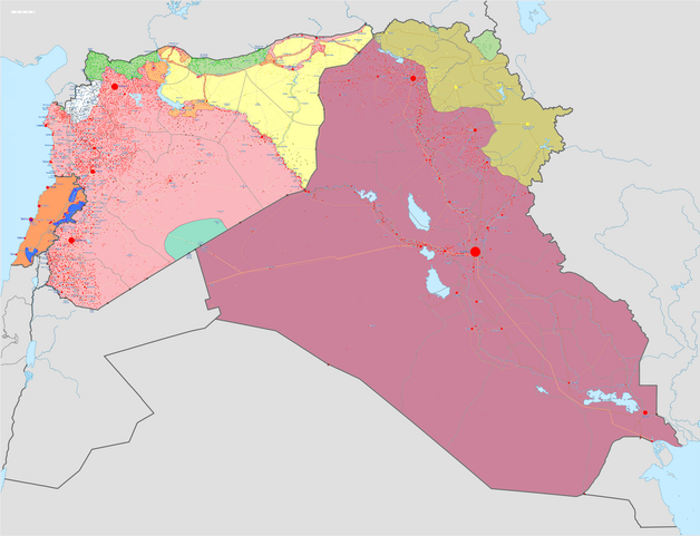
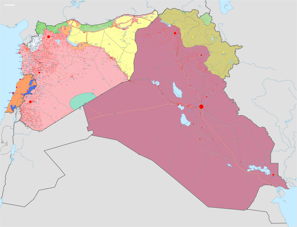
Mapa wojny domowej w Syrii, rebelii w Iraku i rebelii w Libanie kontrolowane przez syryjski rząd
kontrolowane przez iracki rząd
kontrolowane przez libański rząd
kontrolowane przez Hezbollah
kontrolowane przez Państwo Islamskie (ISIL)
kontrolowane przez Dżabhat an-Nusra
kontrolowane przez syryjskich Kurdów
kontrolowane przez irackich Kurdów
legend needs updating |
||||
| Data | |||||
| Źródło |
Praca własna w:en:Template:Syrian, Iraqi, and Lebanese insurgencies detailed map |
||||
| Autor | BlueHypercane761 | ||||
| Inne wersje |
|


.png)


.svg)


.svg)

.svg)


_Territory_Change_2014-2016.gif)

_(within_Northern_Syria).svg)


.png)
.svg)


_map.png)
.svg)


.svg)


|
Ta grafika (historical map) (lub wszystkie grafiki w tym artykule bądź kategorii) powinny zostać przetworzone na grafiki wektorowe jako plik SVG. O zaletach grafik wektorowych można przeczytać na stronie Commons:Media for cleanup. Jeśli wersja SVG tej grafiki jest już dostępna, załaduj ją. Po załadowaniu SVG zamień ten szablon na stronie tej grafiki na szablon {{vector version available|nazwa nowej grafiki.svg}}.
|

|
This image has a useful history, which can be viewed as an animation. |
Licencja
Ja, właściciel praw autorskich do tego dzieła, udostępniam je na poniższej licencji
Ten plik udostępniony jest na licencji Creative Commons Uznanie autorstwa – Na tych samych warunkach 4.0 Międzynarodowe.
- Wolno:
- dzielić się – kopiować, rozpowszechniać, odtwarzać i wykonywać utwór
- modyfikować – tworzyć utwory zależne
- Na następujących warunkach:
- uznanie autorstwa – musisz określić autorstwo utworu, podać link do licencji, a także wskazać czy utwór został zmieniony. Możesz to zrobić w każdy rozsądny sposób, o ile nie będzie to sugerować, że licencjodawca popiera Ciebie lub Twoje użycie utworu.
- na tych samych warunkach – Jeśli zmienia się lub przekształca niniejszy utwór, lub tworzy inny na jego podstawie, można rozpowszechniać powstały w ten sposób nowy utwór tylko na podstawie tej samej lub podobnej licencji.
Historia pliku
Kliknij na odpowiedniej dacie/czasie, aby zobaczyć wersję pliku z tamtego okresu.
| Data/czas | Miniatura | Wymiary | Użytkownik | Opis | |
|---|---|---|---|---|---|
| aktualny | 11:43, 6 wrz 2020 | | 4509 × 3449 (1,74 MB) | LyriaSiders (dyskusja | edycje) | Reports that the SAA have taken over the Doubayat oil and gas field and surrounding area from ISIL elements. Now there is apparently no more hard control by ISIL in the central desert. |
| 15:10, 24 maj 2020 |  | 4509 × 3449 (2,21 MB) | Wiz9999 (dyskusja | edycje) | Updating Revolutionary Commando Army & US presence colour to teal. | |
| 11:27, 7 mar 2020 |  | 4509 × 3449 (1,74 MB) | Nate Hooper (dyskusja | edycje) | Update after the Turkish response. Also, see the discussion page for a further update I have planned. | |
| 03:23, 19 lut 2020 |  | 4509 × 3449 (1,75 MB) | Nate Hooper (dyskusja | edycje) | Update after the Idlib offensive. | |
| 23:45, 7 lut 2020 |  | 4509 × 3449 (1,75 MB) | The Dolly Parton Challenge - Still more country than Alan Jackson (dyskusja | edycje) | Further SAA advances towards Idlib. | |
| 23:26, 7 lut 2020 |  | 4509 × 3449 (2,51 MB) | The Dolly Parton Challenge - Still more country than Alan Jackson (dyskusja | edycje) | Reverted to version as of 00:25, 6 February 2020 (UTC) Never mind | |
| 00:32, 6 lut 2020 |  | 4509 × 3449 (2,51 MB) | TheHatingNerdino666 (dyskusja | edycje) | Fixed the Manbij area. | |
| 00:25, 6 lut 2020 |  | 4509 × 3449 (2,51 MB) | TheHatingNerdino666 (dyskusja | edycje) | Big update as the Syrian Army continues the push towards Idlib. | |
| 17:05, 7 sty 2020 |  | 4509 × 3449 (2,27 MB) | Nate Hooper (dyskusja | edycje) | Wew, it's been a while (I was a way for a bit because I was banned, but I appealed and was successful). Anyway, the SAA have made advances in Idlib. | |
| 17:05, 27 paź 2019 |  | 4509 × 3449 (2,51 MB) | Mlpwtfisthat Backup 7.0 (dyskusja | edycje) | Remove the date. |
Nie możesz nadpisać tego pliku.
Lokalne wykorzystanie pliku
Z tego pliku korzysta więcej niż 100 stron. Poniższa lista pokazuje jedynie 100 pierwszych z nich. Dostępna jest również pełna lista.
- User:Hermes79
- User:Hermes7979
- User:Magog the Ogre/Maps of conflicts/2015 August
- User:Magog the Ogre/Maps of conflicts/2015 December
- User:Magog the Ogre/Maps of conflicts/2015 July
- User:Magog the Ogre/Maps of conflicts/2015 June
- User:Magog the Ogre/Maps of conflicts/2015 November
- User:Magog the Ogre/Maps of conflicts/2015 October
- User:Magog the Ogre/Maps of conflicts/2015 September
- User:Magog the Ogre/Maps of conflicts/2016 April
- User:Magog the Ogre/Maps of conflicts/2016 August
- User:Magog the Ogre/Maps of conflicts/2016 February
- User:Magog the Ogre/Maps of conflicts/2016 January
- User:Magog the Ogre/Maps of conflicts/2016 July
- User:Magog the Ogre/Maps of conflicts/2016 June
- User:Magog the Ogre/Maps of conflicts/2016 March
- User:Magog the Ogre/Maps of conflicts/2016 May
- User:Magog the Ogre/Maps of conflicts/2016 November
- User:Magog the Ogre/Maps of conflicts/2016 October
- User:Magog the Ogre/Maps of conflicts/2016 September
- User:RobiH
- User talk:BlueHypercane761
- File:2013 Hama Offensive.svg
- File:2015 Latakia Frontlines.svg
- File:26032019Syrian, Iraqi, and Lebanese insurgencies.png (przekierowanie do pliku)
- File:Aleppo Offensives 2015.svg
- File:Aleppo offensive (October 2013).svg
- File:Attaques-terroristes-meurtrières-au-21eme-siecle.png
- File:Battle of Daraa City.svg
- File:Battle of Hasakah.svg
- File:Battle of Qamishli.svg
- File:Battle of Raqqa.svg
- File:Battle of Tadmur.svg
- File:Battle of Western Qalamoun.svg
- File:Battlefields in The Global War on Terror.svg
- File:Battlefields in The Global War on Terror - edit03.png
- File:Battlefields in The Global War on Terror - edit04.png
- File:Benghazi Conflict Detailed Map.png
- File:Benghazi Conflict Detailed Map.svg
- File:Boko Haram insurgency map.svg
- File:Countries by soldier count.svg
- File:Deir ez-Zor clashes (2017).svg
- File:Derna Conflict Detailed Map.png
- File:East Congo conflict map.svg
- File:GSPC map.png
- File:ISIS (Grey) Territory Change 2014-2016.gif
- File:Iraqi Civil War map (2014–present).png
- File:Islamist insurgency in Nigeria.svg
- File:Lebanese insurgency.svg
- File:Libyan Civil War.svg
- File:Libyan war final-fr.svg
- File:Map of Ongoing conflicts around the world.png
- File:Map of terror of the Islamic State (ad-Daula al-islāmiyya).png
- File:Mexico states map small war.PNG
- File:Mosul offensive (2015) map.png
- File:Number of Terrorist Incidents.png
- File:Ongoing Conflicts (1).png
- File:Pakistan-Waziristan-Map.png
- File:Political map Afar triangle.png
- File:Rif Damashq.svg
- File:Siege of Homs Map.svg
- File:Sinai insurgency.svg
- File:SituationSyriaIraqLebanon05092020.png (przekierowanie do pliku)
- File:Somali Civil War (2009-present).svg
- File:Syria and Iraq 2014-onward War map.png
- File:Syrian, Iraqi, and Lebanese insurgencies.png
- File:Syrian Civil War map.svg
- File:Syrian civil war.png
- File:Tadmur offensive (2015).jpg
- File:Yemeni Civil War.svg
- Template:City maps of ongoing civil wars
- Category:Aleppo
- Category:Attack
- Category:Battle of Aleppo
- Category:Battles in 2016
- Category:Battles of Syria
- Category:Battles of the Syrian Civil War
- Category:Cities in Syria
- Category:Civil wars
- Category:Conflicts
- Category:Conflicts by continent
- Category:Conflicts by country
- Category:Conflicts by type
- Category:Feuds
- Category:Fights
- Category:Liberation of Palmyra (2016)
- Category:Maps of Aleppo
- Category:Maps of Somali Civil War
- Category:Maps of conflicts
- Category:Maps of disputed territories
- Category:Maps of the Syrian Civil War in 2016
- Category:Military conflicts
- Category:Ongoing armed conflicts
- Category:Quarrels
- Category:Rebellions
- Category:Riots
- Category:Schisms
- Category:Syrian Civil War
- Category:Terrorism
- Category:Uprisings
.svg)
.png)
.png)
.jpg)
Pokaż więcej odnośników do tego pliku.
Globalne wykorzystanie pliku
Ten plik jest wykorzystywany także w innych projektach wiki:
- Wykorzystanie na ar.wikipedia.org
- Wykorzystanie na arz.wikipedia.org
- Wykorzystanie na de.wikipedia.org
- Wykorzystanie na en.wikipedia.org
- Template talk:Lebanese insurgency detailed map
- Module talk:Syrian, Iraqi, and Lebanese insurgencies detailed map
- Module talk:Syrian and Iraqi insurgency detailed map/Archive 1
- Module talk:Iraqi insurgency detailed map/Archive 4
- Talk:Control of cities during the Syrian civil war/Archive 49
- User:AH bharara/sandbox/Islamic State of Iraq and the Levant affiliated Groups
- Talk:Islamic State/Archive 38
- Wikipedia:Graphics Lab/Map workshop/Archive/2016
- Talk:Islamic State/Archive 40
- Talk:Battle of Mosul (2016–2017)/Archive 1
- Talk:Islamic State/Archive 41
- User:KaldeFakta68/sandbox
- User:Edisonabcd/sandbox
- Wykorzystanie na fa.wikipedia.org
- Wykorzystanie na id.wikipedia.org
- Wykorzystanie na ku.wikipedia.org
- Wykorzystanie na mi.wikipedia.org
- Wykorzystanie na pt.wikinews.org
- Wykorzystanie na tr.wikipedia.org
- Wykorzystanie na www.wikidata.org
- Wykorzystanie na zh.wikipedia.org
Metadane
Kategorie:
- Files that need updating
- Maps of Islamic State of Iraq and the Levant
- Current civil wars maps
- Maps of the Syrian Civil War
- Maps of the Syrian Civil War in 2018
- Maps of the Syrian Civil War in 2017
- Maps of the Syrian Civil War in 2016
- Maps of the Syrian Civil War in 2015
- Maps of the Iraqi Civil War (2014–2017)
- Maps of Lebanon
- Maps of Iraqi Kurdistan
- Maps of Syrian Kurdistan
- Conflicts in 2018
- Conflicts in 2017
- Conflicts in 2016
- Conflicts in 2015
- 2017 in Iraq
- 2016 in Iraq
- 2015 in Iraq
- 2017 in politics of Lebanon
- 2016 in Lebanon
- 2015 in Lebanon