File:Syrmia.png
跳转到导航
跳转到搜索

本预览的尺寸:800 × 489像素。 其他分辨率:320 × 196像素 | 640 × 392像素 | 1,082 × 662像素。
原始文件 (1,082 × 662像素,文件大小:58 KB,MIME类型:image/png)
说明
说明
添加一行文字以描述该文件所表现的内容
摘要
[编辑]
| 描述 |
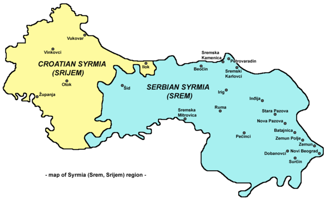
English: Map of Syrmia region.
Српски / srpski: Мапа Срема
Hrvatski: Mapa Srijema |
| 日期 | 2006年12月28日 (原始上传日期) |
| 来源 | 自己的作品 |
| 作者 | PANONIAN |
许可协议
[编辑]
self made map by user:PANONIAN

|
This map has been uploaded by Electionworld from en.wikipedia.org to enable the |
| 我,本作品著作权人,释出本作品至公有领域。这适用于全世界。 在一些国家这可能不合法;如果是这样的话,那么: 我无条件地授予任何人以任何目的使用本作品的权利,除非这些条件是法律规定所必需的。 |
References
[编辑]
References for historical/geographical borders of Syrmia and modern state borders:
- Školski istorijski atlas, Zavod za izdavanje udžbenika Socijalističke Republike Srbije, Beograd, 1970.
- Milovan Radovanović, Kosovo i Metohija - antropogeografske, istorijskogeografske, demografske i geopolitičke osnove, Beograd, 2008.
- Slobodan Radovanović, Geografski atlas, Magic Map, Smederevska Palanka, 2001.
- Školski geografski atlas, Intersistem Kartografija, Beograd, 2004.
- Denis Šehić - Demir Šehić, Geografski atlas Srbije, Beograd, 2007.
References for sizable cities and towns:
- Popis stanovništva, domaćinstava i stanova u 2002., Stanovništvo, nacionalna ili etnička pripadnost - Podaci po naseljima, knjiga 1, Republika Srbija - Republički zavod za statistiku, Beograd, februar 2003.
- http://world-gazetteer.com/ archive copy at the Wayback Machine
Other versions
[编辑]
- Russian language version - File:Срем.png
文件历史
点击某个日期/时间查看对应时刻的文件。
| 日期/时间 | 缩略图 | 大小 | 用户 | 备注 | |
|---|---|---|---|---|---|
| 当前 | 2009年9月16日 (三) 21:16 | | 1,082 × 662(58 KB) | WikiEditor2004(留言 | 贡献) | Reverted to version as of 21:14, 16 September 2009 - fixing thumbnail problem |
| 2009年9月16日 (三) 21:16 |  | 1,008 × 600(41 KB) | WikiEditor2004(留言 | 贡献) | Reverted to version as of 15:31, 28 December 2006 - fixing thumbnail problem | |
| 2009年9月16日 (三) 21:14 |  | 1,082 × 662(58 KB) | WikiEditor2004(留言 | 贡献) | ||
| 2006年12月28日 (四) 15:31 |  | 1,008 × 600(41 KB) | Electionworld(留言 | 贡献) | {{ew|en|PANONIAN}} Map of Syrmia region (self made) {{PD-self}} Category:Maps of Vojvodina Category:Maps of Serbia Category:Maps of Croatia |
您不可以覆盖此文件。
文件用途
以下3个页面使用本文件:
全域文件用途
以下其他wiki使用此文件:
- an.wikipedia.org上的用途
- bs.wikipedia.org上的用途
- ca.wikipedia.org上的用途
- cs.wikipedia.org上的用途
- de.wikipedia.org上的用途
- de.wiktionary.org上的用途
- en.wikipedia.org上的用途
- eo.wikipedia.org上的用途
- es.wikipedia.org上的用途
- et.wikipedia.org上的用途
- fr.wikipedia.org上的用途
- gl.wikipedia.org上的用途
- hr.wikipedia.org上的用途
- hu.wikipedia.org上的用途
- id.wikipedia.org上的用途
- it.wikipedia.org上的用途
- ja.wikipedia.org上的用途
- ko.wikipedia.org上的用途
- mk.wikipedia.org上的用途
- nl.wikipedia.org上的用途
- nn.wikipedia.org上的用途
- pl.wikipedia.org上的用途
- pt.wikipedia.org上的用途
- ro.wikipedia.org上的用途
- rue.wikipedia.org上的用途
- sh.wikipedia.org上的用途
- sk.wikipedia.org上的用途
- sq.wikipedia.org上的用途
- sv.wikipedia.org上的用途
- tr.wikipedia.org上的用途
- uk.wikipedia.org上的用途
- zh.wikipedia.org上的用途