File:Szydłowiec (gmina) location map.png

Fichier d’origine (667 × 958 pixels, taille du fichier : 87 kio, type MIME : image/png)
Légendes
Légendes
| Description |
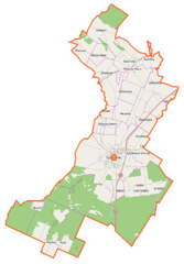
Polski: Mapa gminy Szydłowiec, Polska
English: Map of Gmina Szydłowiec, Poland |
|||||||||
| Date | ||||||||||
| Source | Il existe probablement une [page https://wiki.openstreetmap.org/wiki/Szyd%C5%82owiec+%28gmina%29 sur le wiki d'OpenStreetMap sur ce sujet : Szydłowiec (gmina)] | |||||||||
| Créé par |
OpenStreetMap contributors contributeurs d'OpenStreetMap |
|||||||||
| Autorisation (Réutilisation de ce fichier) |
Les données d'OpenStreetMap sont disponibles sous la license Open Database (détails). Les cartes sont publiées sous license Creative Commons Attribution-Partage dans les Mêmes Conditions 2.0 (CC-BY-SA 2.0).
Ce fichier est disponible selon les termes de la licence Creative Commons Attribution – Partage dans les Mêmes Conditions 2.0 Générique
|
|||||||||
| Données géotemporelles | ||||||||||
| Rectangle englobant |
|
|||||||||
| Géoréférencement | Si c'est inapproprié, définissez warp_status = skip pour masquer. | |||||||||
Historique du fichier
Cliquer sur une date et heure pour voir le fichier tel qu'il était à ce moment-là.
| Date et heure | Vignette | Dimensions | Utilisateur | Commentaire | |
|---|---|---|---|---|---|
| actuel | 8 octobre 2014 à 11:13 | | 667 × 958 (87 kio) | VanWiel (d | contributions) | {{OpenStreetMap | name = Szydłowiec (gmina) | location = Szydłowiec (gmina) | description = {{pl|Mapa gminy Szydłowiec, Polska}} {{en|Map of Gmina Szydłowiec, Poland}} | top = 51.3465 | left =... |
Vous ne pouvez pas remplacer ce fichier.
Utilisations locales du fichier
Aucune page n’utilise ce fichier.
Utilisations du fichier sur d’autres wikis
Les autres wikis suivants utilisent ce fichier :
- Utilisation sur de.wikipedia.org
- Utilisation sur fr.wikipedia.org
- Utilisation sur pl.wikipedia.org
- Szydłowiec (gmina)
- Chustki
- Ciechostowice
- Krzcięcin
- Korzyce
- Majdów
- Omięcin (województwo mazowieckie)
- Rybianka
- Świniów
- Wola Korzeniowa
- Zastronie
- Barak (województwo mazowieckie)
- Mszadla (województwo mazowieckie)
- Świerczek (województwo mazowieckie)
- Wilcza Wola (województwo mazowieckie)
- Wysocko (województwo mazowieckie)
- Wysoka (województwo mazowieckie)
- Hucisko (powiat szydłowiecki)
- Jankowice (powiat szydłowiecki)
- Łazy (powiat szydłowiecki)
- Sadek (powiat szydłowiecki)
- Szydłówek (powiat szydłowiecki)
- Zdziechów (wieś w powiecie szydłowieckim)
- Szydłowiec
- Ratusz w Szydłowcu
- Ziomaki (powiat szydłowiecki)
- Synagoga Garbarska w Szydłowcu
- Kościół św. Zygmunta w Szydłowcu
- Zamek w Szydłowcu
- Cmentarz żydowski w Szydłowcu
- Długosz (wieś)
- Osiedle Kolejowa
- Polanki (Szydłowiec)
- Stara Wieś (Szydłowiec)
- Podzamcze (Szydłowiec)
- Główne Miasto (Szydłowiec)
- Książek (Szydłowiec)
- Podgórze (Szydłowiec)
- Irena (Szydłowiec)
- Cmentarz Komunalny w Szydłowcu
- Stanisławów (Wysocko)
- Parafia św. Zygmunta w Szydłowcu
- Osiedle Kościuszki (Szydłowiec)
- Rynek Wielki w Szydłowcu
- Pomnik Tadeusza Kościuszki w Szydłowcu
- Pręgierz w Szydłowcu
- Góra Trzech Krzyży w Szydłowcu
Voir davantage sur l’utilisation globale de ce fichier.
_location_map.png)
_location_map.png&oldid=901394051)