File:TD 6 (Fay) 05 sept 2002 1700Z (full).jpg
Aller à la navigation
Aller à la recherche
Pas de plus haute résolution disponible.
TD_6_(Fay)_05_sept_2002_1700Z_(full).jpg (540 × 540 pixels, taille du fichier : 63 kio, type MIME : image/jpeg)
Légendes
Légendes
Ajoutez en une ligne la description de ce que représente ce fichier
Description
[modifier]_05_sept_2002_1700Z_(full).jpg&action=edit§ion=1)
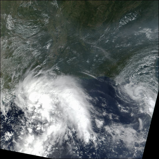
| Description | Tropical Storm Fay, the sixth named tropical storm in the Atlantic this year, came ashore in Texas on September 6, 2002. The tropical storm can be seen above the Gulf of Mexico in this true-color image taken on September 5 by the Moderate Resolution Imaging Spectroradiometer (MODIS), flying aboard NASA's Terra spacecraft. The storm, now centered over San Antonio, Texas, has produced over eight inches of rainfall so far in some regions and has led to flash flooding throughout southern Texas. The rain is expected to let up slowly and dissipate by Wednesday. |
| Date | |
| Source | http://visibleearth.nasa.gov/view_rec.php?id=18027 |
| Auteur | Image by Jesse Allen, based on data from the MODIS Rapid Response Team at NASA-GSFC. |
Description
Conditions d’utilisation
[modifier]_05_sept_2002_1700Z_(full).jpg&action=edit§ion=2)
| Ce fichier provient de la NASA. Sauf exception, les documents créés par la NASA ne sont pas soumis à copyright. Pour plus d'informations, voir la politique de copyright de la NASA. | ||
 |
Attention :
|
Historique du fichier
Cliquer sur une date et heure pour voir le fichier tel qu'il était à ce moment-là.
| Date et heure | Vignette | Dimensions | Utilisateur | Commentaire | |
|---|---|---|---|---|---|
| actuel | 9 août 2008 à 13:27 | | 540 × 540 (63 kio) | Arh'lupia (d | contributions) | {{Information |Description= Tropical Storm Fay, the sixth named tropical storm in the Atlantic this year, came ashore in Texas on September 6, 2002. The tropical storm can be seen above the Gulf of Mexico in this true-color image taken on September 5 by t |
Vous ne pouvez pas remplacer ce fichier.
Utilisations locales du fichier
Aucune page n’utilise ce fichier.
Utilisations du fichier sur d’autres wikis
Les autres wikis suivants utilisent ce fichier :
- Utilisation sur fr.wikipedia.org
_05_sept_2002_1700Z_(full).jpg&oldid=568564646)