File:TS Chris 2000 1015 UTC.jpg
Aller à la navigation
Aller à la recherche
Pas de plus haute résolution disponible.
TS_Chris_2000_1015_UTC.jpg (602 × 480 pixels, taille du fichier : 37 kio, type MIME : image/jpeg)
Légendes
Légendes
Ajoutez en une ligne la description de ce que représente ce fichier
Description
[modifier]
| Description |
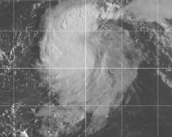
English: GOES 8 Visible satellite image taken at 1015 UTC 18 August near the time Chris was classified as a tropical storm
Français : GOES 8 Image satellite dans le visible à 1015 UTCle 18 Août, au moment où Chris est classé tempête tropicale. |
| Date | UTC, première date de publication inconnue |
| Source | http://www.nhc.noaa.gov/2000chris.html |
| Auteur | GOES 8, satellite du National Weather Service, organisme de la NOAA, dont dépend le NHC, National Hurricane Center |
| Autorisation (Réutilisation de ce fichier) |
http://www.weather.gov/disclaimer.php : "The information on government servers are in the public domain, unless specifically annotated otherwise, and may be used freely by the public so long as you do not 1) claim it is your own (e.g. by claiming copyright for NWS information -- see below), 2) use it in a manner that implies an endorsement or affiliation with NOAA/NWS, or 3) modify it in content and then present it as official government material. You also cannot present information of your own in a way that makes it appear to be official government information.. " |
16.2° Nord 55.4° Ouest
Conditions d’utilisation
[modifier]
Cette image est dans le domaine public car son contenu provient de la
National Oceanic and Atmospheric Administration , réalisé par un employé dans le cadre de ses activités professionnelles.
|
Historique du fichier
Cliquer sur une date et heure pour voir le fichier tel qu'il était à ce moment-là.
| Date et heure | Vignette | Dimensions | Utilisateur | Commentaire | |
|---|---|---|---|---|---|
| actuel | 29 juillet 2008 à 14:00 | | 602 × 480 (37 kio) | Arh'lupia (d | contributions) | GOES 8 Visible satellite image taken at 1015 UTC 18 August near the time Chris was classified as a tropical storm GOES 8 Image satellite dans le visible à 1015 UTCle 18 Août, au moment où Chris est classé tempête tropicale. 16.2° Nord 55.4° Ouest |
| 29 juillet 2008 à 13:59 |  | 222 × 411 (27 kio) | Arh'lupia (d | contributions) | {{Information |Description={{en|1=GOES 8 Visible satellite image taken at 1015 UTC 18 August near the time Chris was classified as a tropical storm}} {{fr|1=GOES 8 Image satellite dans le visible à 1015 UTCle 18 Août, au moment où Chris est classé tem |
Vous ne pouvez pas remplacer ce fichier.
Utilisations locales du fichier
Aucune page n’utilise ce fichier.
Utilisations du fichier sur d’autres wikis
Les autres wikis suivants utilisent ce fichier :
- Utilisation sur fr.wikipedia.org