File:Tacca Distribution.PNG
ნავიგაციაზე გადასვლა
ძიებაზე გადასვლა
ზომა წინასწარი გადახედვისას: 800 × 338 პიქსელი. სხვა გაფართოება: 320 × 135 პიქსელი | 640 × 270 პიქსელი | 1 480 × 625 პიქსელი.
თავდაპირველი ფაილი (1 480 × 625 პიქსელი, ფაილის ზომა: 39 კბ, MIME ტიპი: image/png)
Captions
Captions
Add a one-line explanation of what this file represents

|
უცნობი ტიპის «biogeographical map» ეს გამოსახულება უნდა იყოს გადახატული .svg ფორმატში. ყოველივე ეს გვაძლევს რამდენიმე მოგებას, რის შესახებაც შეგიძლიათ წაიკითხოთ Commons:Media for cleanup. თუ თქვენ უკვე გაქვთ .svg ვერსია, ძალიან გთხოვთ ატვირთოთ იგი. ატვირთვის შემდეგ გთხოვთ შეცვალოთ ეს თარგი შემდეგით - {{Vector version available|ფაილის სახელი.svg}}.
|
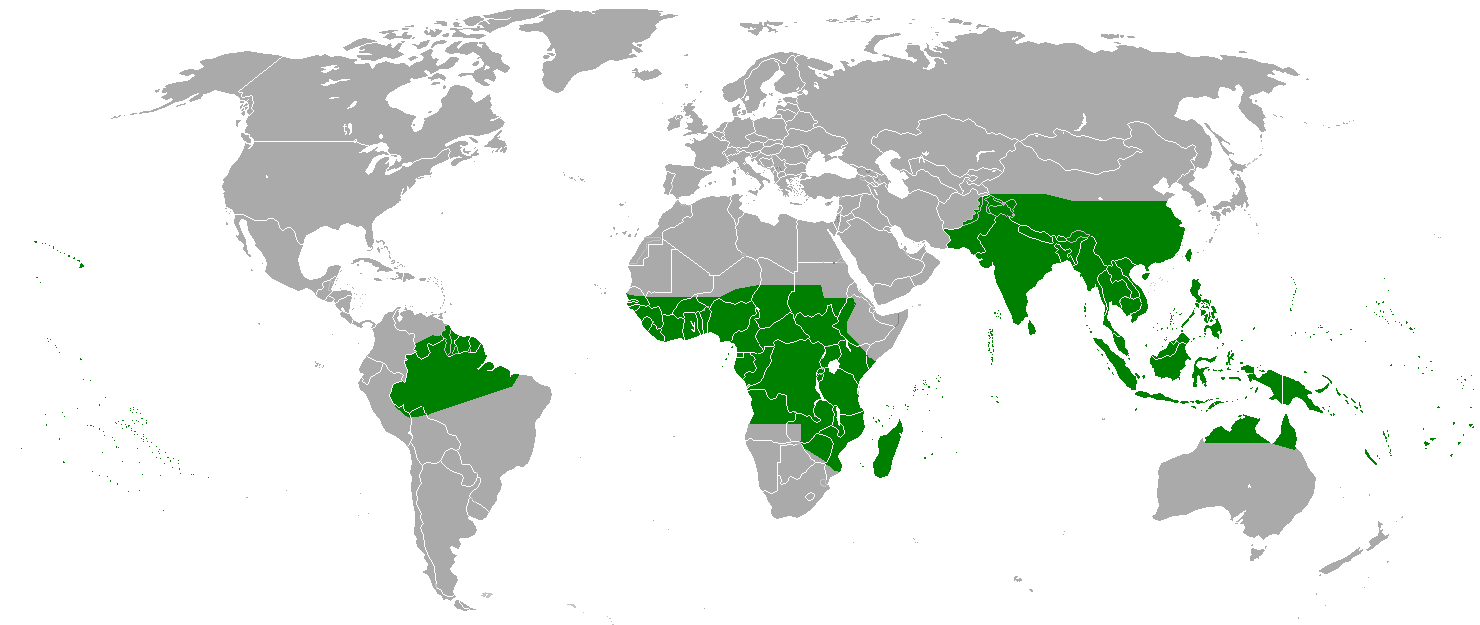
| აღწერა | Distribution of Taccaceae. Source for information: APWeb, World Checklist of Selected Plant Families, Kew Gardens |
| თარიღი | (UTC) |
| წყარო | |
| ავტორი |
|
| ეს არის რედაქტირებული ფაილი, რომლის ორიგინალი იყო ციფრულად დამუშავებული.ცვლილება შემდეგია: Distribution of Taccaceae. ორიგინალი ინახება აქ: BlankMap-World.png. რედაქტირება მოახდინა Enzo^.
|
| ეს ნამუშევარი მისი ავტორის Vardion მიერ გადაცემულია საზოგადოებრივ დომენში. ეს მოქმედებს მთელი მსოფლიოს მასშტაბით. ზოგიერთ ქვეყანაში ეს შეიძლება იურიდიულად შეუძლებელი იყოს, ასეთ შემთხვევაში: |
ატვირთვის ჟურნალი
[რედაქტირება]
This image is a derivative work of the following images:
- File:BlankMap-World.png licensed with PD-user
- 2011-01-17T05:15:03Z The spesh man 1480x625 (61925 Bytes) update
- 2011-01-06T02:49:36Z The spesh man 1480x625 (61663 Bytes) fixing borders, have south sudan ready incase of independence.
- 2011-01-06T02:32:37Z The spesh man 1480x625 (61554 Bytes) fixed borders
- 2010-12-25T22:09:00Z The spesh man 1480x625 (61554 Bytes) adding and fixing
- 2010-11-23T15:20:19Z Chermundy 1480x625 (37505 Bytes) -artefacts
- 2010-11-22T13:35:04Z Chermundy 1480x625 (37720 Bytes) +islands at Atlantic & Indian Oceans, near California coast; lakes; locations of islands
- 2010-10-29T23:12:34Z The spesh man 1480x625 (60473 Bytes) adding italian, eritian, and pacific islands
- 2010-09-11T14:48:36Z The spesh man 1480x625 (60155 Bytes) fixing [[Bhutan]]
- 2010-08-18T00:22:07Z The spesh man 1480x625 (60004 Bytes) adding paracel and spratley islands, adding more disputes
- 2010-08-17T02:45:48Z The spesh man 1480x625 (52474 Bytes) adding islands and disputed islands
- 2010-08-12T01:16:58Z The spesh man 1480x625 (59310 Bytes) fixing asia and europe
- 2010-08-08T02:10:32Z The spesh man 1480x625 (52275 Bytes) USE MAP BELOW THE MAP BELOW
- 2010-08-08T02:09:17Z The spesh man 1480x625 (52278 Bytes) Reverted to version as of 02:34, 26 July 2010
- 2010-08-08T02:08:29Z The spesh man 1480x625 (52275 Bytes) something is wrong with my computer, whenever this happens, i am on a [[Windows Xp]] (Mets beat Phillies!!!)
- 2010-08-08T02:06:23Z The spesh man 1480x625 (52275 Bytes) uploading for.. (mets beat phillies)
- 2010-08-08T02:03:45Z The spesh man 1480x628 (52360 Bytes) not showing changes (NYM BEAT PHA 1-0 YAAAY)
- 2010-08-08T02:00:47Z The spesh man 1480x628 (52360 Bytes) changing light gray. (New York Mets Beat Philadelphia Phillies yaaaaay 1-0) Fixing Israel/palestine
- 2010-07-26T02:34:11Z The spesh man 1480x625 (52278 Bytes) use the map below me.
- 2010-07-26T02:33:28Z The spesh man 1480x625 (52278 Bytes) Use THIS ONE
- 2010-07-26T02:31:46Z The spesh man 1480x628 (52389 Bytes) Reverted to version as of 02:28, 26 July 2010
- 2010-07-26T02:30:23Z The spesh man 1480x628 (52389 Bytes) removing blue!
- 2010-07-26T02:28:34Z The spesh man 1480x628 (52389 Bytes) removed odd blue in east timor-indonesia border, it is disputed
- 2010-07-11T19:36:11Z The spesh man 1480x625 (59305 Bytes) adding much more disputes, fixing caribbean
- 2010-05-19T23:34:12Z The spesh man 1480x625 (58601 Bytes) Added more of the Pacific (may need much adjusting without reverting)
- 2010-04-01T23:47:19Z The spesh man 1425x625 (57601 Bytes) adding other non recognized territories
- 2010-03-30T19:29:06Z The spesh man 1425x625 (50971 Bytes) adding disputed areas, fixing french polynesia, (may need adjusting)
- 2010-02-01T03:10:44Z R-41 1425x625 (31271 Bytes) Since Kosovo is shown as a disputed territory due to it being partially recognized, I have added other partially recognized territories.
- 2009-11-21T22:49:46Z The spesh man 1425x625 (50488 Bytes) fixing mid atlantic area of usa
- 2009-11-21T22:49:46Z The spesh man 1425x625 (50488 Bytes) fixing mid atlantic area of usa
- 2009-07-15T09:56:40Z Hoshie 1425x625 (58087 Bytes) added the Musandam exclave of Oman
- 2009-07-15T09:56:10Z Hoshie 1425x625 (58087 Bytes) Added Musandam exclave (Oman)
- 2009-01-11T22:31:55Z Drieskamp 1425x625 (58087 Bytes) this is an obsolete map.
- 2009-01-10T23:46:15Z Emilfaro 1425x625 (60678 Bytes) Bringing map to accordance with the Wikipedia Standard convention on map colors.
- 2008-09-27T10:52:47Z Hoshie 1425x625 (58087 Bytes) Re-added Kosovo; see [[Image talk:Continental-Europe-map.png#Kosovo - a solution]]
- 2008-09-16T00:00:45Z Tocino 1425x625 (58067 Bytes) Reverted to version as of 17:22, 15 September 2008
- 2008-09-15T20:44:31Z Cradel 1425x625 (58091 Bytes) Reverted to version as of 19:25, 14 September 2008
- 2008-09-15T17:22:47Z Tocino 1425x625 (58067 Bytes) Reverted to version as of 07:29, 14 September 2008
- 2008-09-14T19:25:58Z Cradel 1425x625 (58091 Bytes) Reverted to version as of 13:33, 11 September 2008
- 2008-09-14T07:29:32Z Hoshie 1425x625 (58067 Bytes) removed Kosovo from a previous version of the map so that changes made before can show
- 2008-09-11T13:33:05Z EmilJ 1425x625 (58091 Bytes) Reverted to version as of 04:01, 12 April 2008
- 2008-07-31T14:48:33Z Avala 1425x625 (15167 Bytes)
- 2008-04-12T04:01:57Z Hoshie 1425x625 (58091 Bytes) added St. John (USVI), St. Pierre and Miquelon, Turks and Caicos
- 2008-04-05T07:54:33Z Hoshie 1425x625 (58019 Bytes) redrew Kosovo; added the insular parts of the French S. and Antarctic Lands based off of [[:Image:TAAF-CIA WFB Map.png]]
- 2008-02-17T17:00:48Z IAMTHEEGGMAN 1425x625 (58032 Bytes) Kosovo has declared independence from Serbia
- 2008-01-26T17:10:27Z Time3000 1425x625 (15167 Bytes) Optimise using Optipng, AdvanceCOMP and PNGOUT
- 2007-11-26T19:57:31Z Hoshie 1425x625 (50585 Bytes) re-drew Australia's indian ocean territories
- 2007-11-09T23:35:30Z Hoshie 1425x625 (50603 Bytes) added Christmas Island % Cocos (Keeling) Islands and redrew Cabinda (Angola); under same lic. as before.
- 2007-11-05T03:59:57Z Wiz9999 1425x625 (50585 Bytes) Fixed colour issue in Luxembourg
- 2007-10-04T00:12:32Z R-41 1425x625 (31038 Bytes) Corrected the size of a British island added on the English Channel and corrected the size and position of two Greek islands on Greece's western coast.
- 2007-09-25T11:12:30Z Hoshie 1425x625 (50558 Bytes) added Clipperton Island, St. Barthelemy, St. Martin, Yns Mon (Anglesey), the Isle of Wight. the Chagos (BIOT), SBAs on Cyprus, and Lough Neagh in NI. under same lic. as before.
Uploaded with derivativeFX
ფაილის ისტორია
დააწკაპუნეთ თარიღზე/დროზე, რათა იხილოთ ფაილი, როგორც ის მაშინ გამოიყურებოდა.
| თარიღი/დრო | მინიატიურა | განზომილებები | მომხმარებელი | კომენტარი | |
|---|---|---|---|---|---|
| მიმდინარე | 11:14, 4 ოქტომბერი 2013 | | 1 480 × 625 (39 კბ) | Blackfish (განხილვა | წვლილი) | South Sudan added |
| 19:52, 15 თებერვალი 2011 |  | 1 480 × 625 (61 კბ) | Enzo^ (განხილვა | წვლილი) | Boundaries simplified | |
| 18:51, 15 თებერვალი 2011 |  | 1 480 × 625 (62 კბ) | Enzo^ (განხილვა | წვლილი) | Modifications: - Southern America – distribution extended according to TDWG codes, source: [http://apps.kew.org/wcsp/home.do World Checklist of Selected Plant Families database], - Africa – distribution extended according to TDWG codes (source as abo | |
| 19:16, 14 თებერვალი 2011 |  | 1 480 × 625 (62 კბ) | Enzo^ (განხილვა | წვლილი) | {{Information |Description=Distribution of Taccaceae. Source for information: [http://www.mobot.org/mobot/research/apweb/orders/dioscorealesweb.htm#Tacca APWeb] |Source=*File:BlankMap-World.png |Date=2011-02-14 19:13 (UTC) |Author=*[[:File:BlankMap- |
თქვენ არ შეგიძლიათ ამ ფაილზე გადაწერა.
ფაილის გამოყენება
ეს ფაილი არცერთ გვერდზე არ გამოიყენება.
ფაილის გლობალური გამოყენება
ეს ფაილი გამოიყენება შემდეგ ვიკებში:
- გამოყენება en.wiktionary.org-ში
- გამოყენება pl.wikipedia.org-ში