File:Tagiura map.jpg
跳至導覽
跳至搜尋

預覽大小:800 × 437 像素。 其他解析度:320 × 175 像素 | 640 × 350 像素 | 1,034 × 565 像素。
原始檔案 (1,034 × 565 像素,檔案大小:190 KB,MIME 類型:image/jpeg)
說明
說明
添加單行說明來描述出檔案所代表的內容
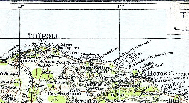
| 描述 | A 1913 Map of the region where Tripoli and Tajura Oasis lies, in the Italian colonial Tripolitania Province (present day northwest Libya. | ||||
| 日期 | |||||
| 來源 | G. Ricchieri, La Libia, Milan, Federazione Italiana delle Biblioteche Popolari, 1913 | ||||
| 作者 | unknown (offered by TCI, Touring Club Italiano) | ||||
| 授權許可 (重用此檔案) |
|
||||
檔案歷史
點選日期/時間以檢視該時間的檔案版本。
| 日期/時間 | 縮圖 | 尺寸 | 用戶 | 備註 | |
|---|---|---|---|---|---|
| 目前 | 2010年8月27日 (五) 17:11 | | 1,034 × 565(190 KB) | Victor Korniyenko(對話 | 貢獻) | new edition. |
| 2007年1月8日 (一) 15:35 |  | 1,034 × 565(130 KB) | Vermondo(對話 | 貢獻) | {{Information |Description=A Map of the region where Tajura Oasis lies |Source=scanned by uploader from G. Ricchieri, ''La Libia'', Milan, Federazione Italiana delle Biblioteche Popolari, 1913 |Date=1913 |Author=unknown (offered by TCI, Touring Club Itali |
無法覆蓋此檔案。
檔案用途
沒有使用此檔案的頁面。
全域檔案使用狀況
以下其他 wiki 使用了這個檔案:
- de.wikipedia.org 的使用狀況
- en.wikipedia.org 的使用狀況
- fr.wikipedia.org 的使用狀況
- it.wikipedia.org 的使用狀況
- ru.wikipedia.org 的使用狀況
- zh.wikipedia.org 的使用狀況