File:Taipei Metro official map 2018 optimised.png
跳至導覽
跳至搜尋
預覽大小:439 × 599 像素。 其他解析度:176 × 240 像素 | 352 × 480 像素 | 563 × 768 像素 | 750 × 1,024 像素 | 1,501 × 2,048 像素 | 2,805 × 3,827 像素。
原始檔案 (2,805 × 3,827 像素,檔案大小:975 KB,MIME 類型:image/png)
說明
說明
添加單行說明來描述出檔案所代表的內容
摘要
[編輯]
| 描述 |
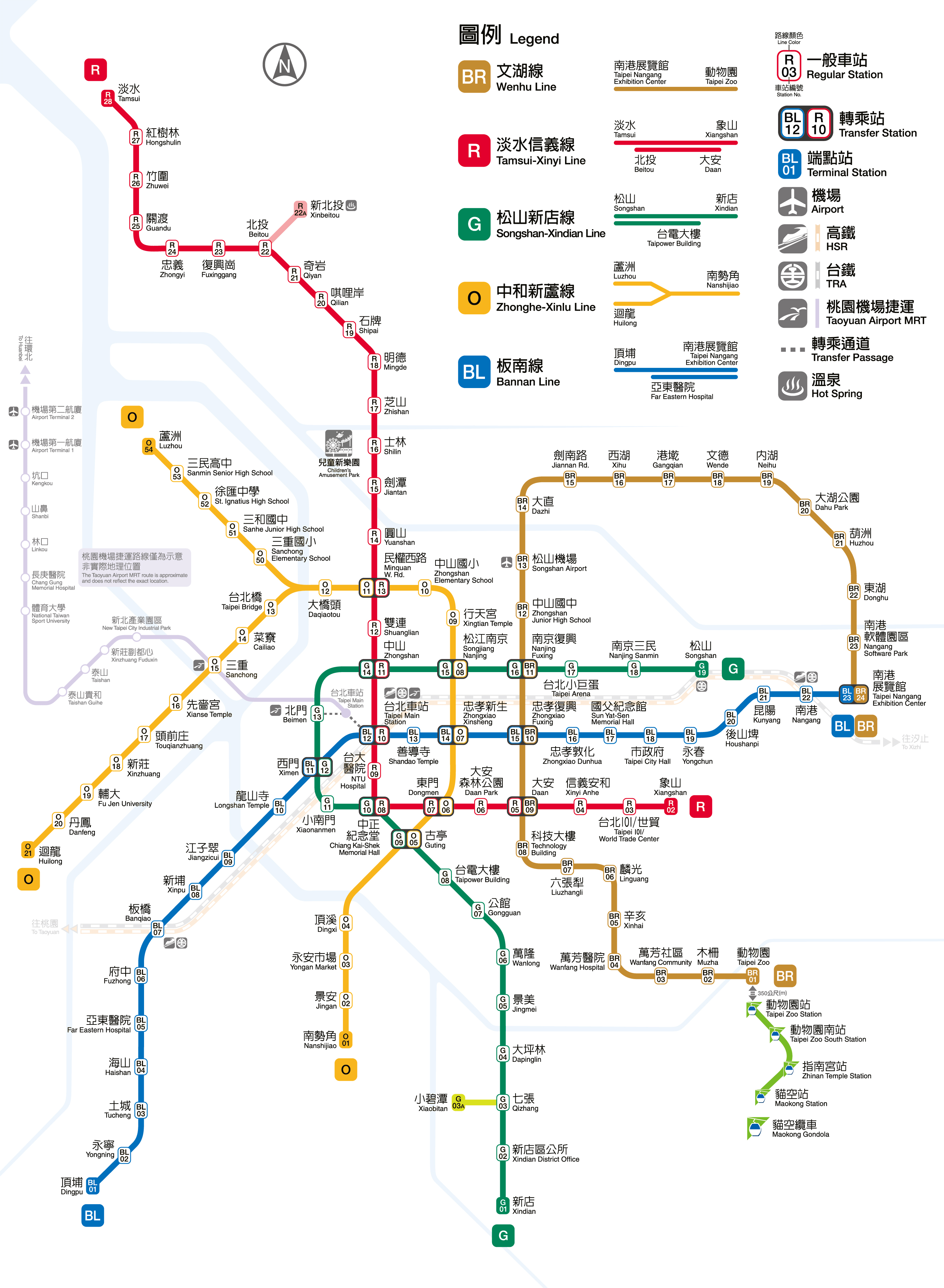
English: Official route map of Taipei Metro in 2018 |
| 日期 | |
| 來源 | Optimised image of http://web.metro.taipei/img/all/metrotaipeimap.jpg |
| 作者 | Own work derived from that of Taipei Rapid Transit Corporation |
授權條款
[編輯]

|
本檔案的著作權持有者,在註明所有人姓名的前提下,允許任何人使用本檔案於任何用途。包含再散佈、衍生作品、商業用途及其他用途。 |
|
|
Declaration regarding Open Access to Government Data Online:
| “ | To promote applications of online government information, all data and materials on the Taipei Rapid Transit Corporation (hereinafter referred to as TRTC) website shall be accessible by the public without compensation, non-exclusively, and shall be sublicensed to other parties. Users shall be able to reproduce, adapt, edit, publicly transmit, or utilize the data in other ways. Users shall also be given an irrevocable license to develop products or services based on the data (referred to as derivative works) without any restrictions with regard to time or territory. In addition, users shall not be required to obtain the license in written or other forms from the TRTC but will, however, be required to clearly accredit the relevant source. | ” |
檔案歷史
點選日期/時間以檢視該時間的檔案版本。
| 日期/時間 | 縮圖 | 尺寸 | 使用者 | 備註 | |
|---|---|---|---|---|---|
| 目前 | 2019年2月17日 (日) 18:15 | | 2,805 × 3,827(975 KB) | Happy60907(留言 | 貢獻) | Increase image quality. |
| 2018年9月13日 (四) 06:46 |  | 2,806 × 3,828(573 KB) | Szqecs(留言 | 貢獻) | User created page with UploadWizard |
無法覆蓋此檔案。
檔案用途
下列10個頁面有用到此檔案:
- User:Chumwa/OgreBot/Potential transport maps/2018 September 11-20
- User:Chumwa/OgreBot/Potential transport maps/2019 February 10-18
- User:Chumwa/OgreBot/Public transport information/2018 September 11-20
- User:Chumwa/OgreBot/Public transport information/2019 February 10-18
- User:Chumwa/OgreBot/Transport Maps/2018 September 11-20
- User:Chumwa/OgreBot/Transport Maps/2019 February 10-18
- User:Chumwa/OgreBot/Travel and communication maps/2018 September 11-20
- User:Chumwa/OgreBot/Travel and communication maps/2019 February 10-18
- File:Taipei Metro official map.jpg (檔案重新導向)
- File:Taipei Metro official map 2018.jpg (檔案重新導向)
全域檔案使用狀況
以下其他 wiki 使用了這個檔案:
- zh.wikipedia.org 的使用狀況