File:Tambora EFS highres STS049 STS049-97-54.jpg
跳至導覽
跳至搜尋
預覽大小:596 × 599 像素。 其他解析度:239 × 240 像素 | 477 × 480 像素 | 764 × 768 像素 | 1,018 × 1,024 像素 | 2,037 × 2,048 像素 | 3,940 × 3,962 像素。
原始檔案 (3,940 × 3,962 像素,檔案大小:2.61 MB,MIME 類型:image/jpeg)
說明
說明
添加單行說明來描述出檔案所代表的內容
摘要
[編輯]
| 描述 |
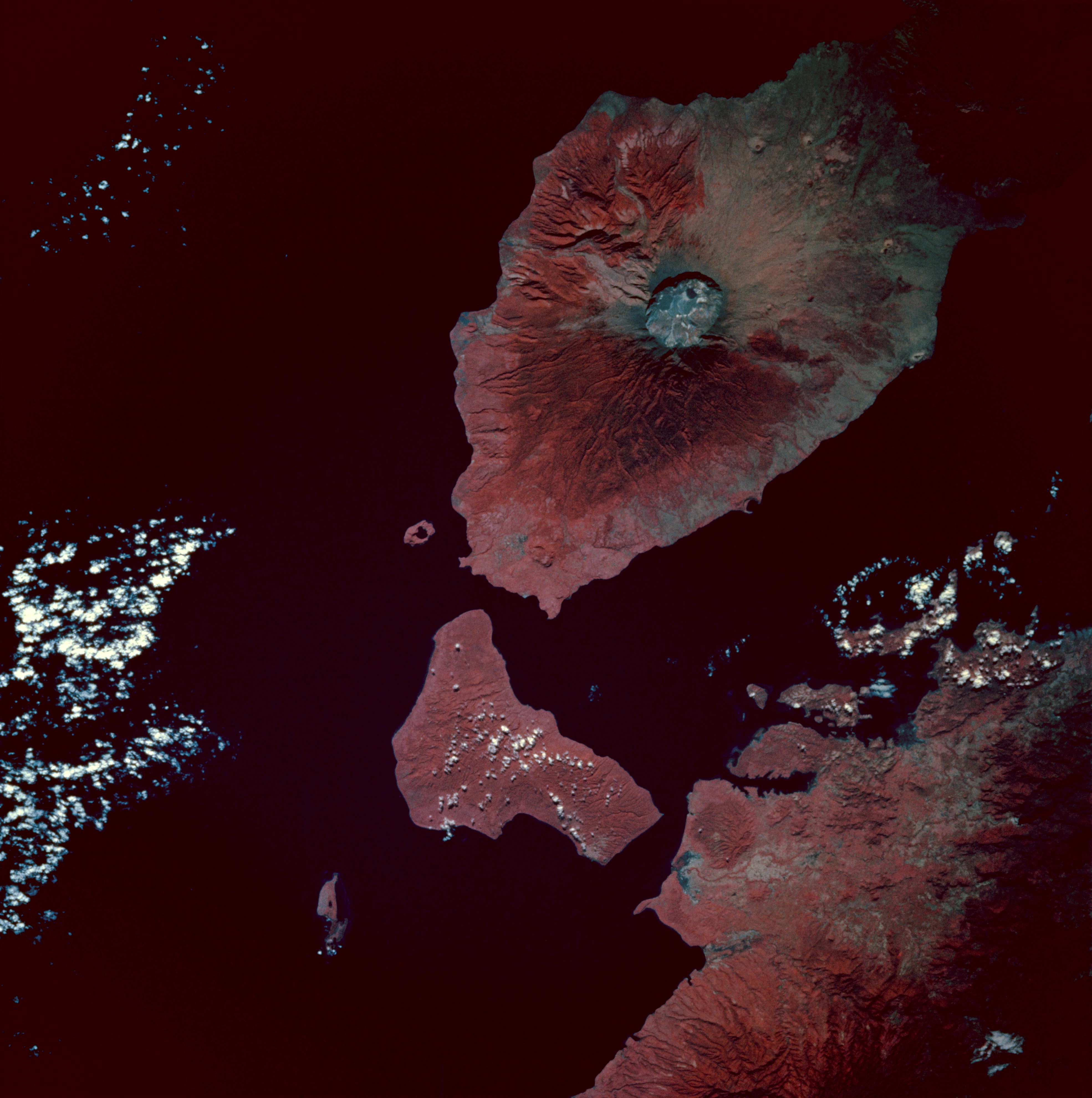
Infrared image of Mount Tambora, Sumbawa Island, Indonesia. Taken from the space shuttle Endeavour at 0:54 GMT on 13 May 1992.
|
| 日期 | |
| 來源 | [2] |
| 作者 | Image Science and Analysis Laboratory, NASA-Johnson Space Center. "The Gateway to Astronaut Photography of Earth". |
授權條款
[編輯]
| 本作品由NASA創作,屬於公有領域。根據NASA的版權政策:“NASA的創作除非另有聲明否則不受版權保護。”(參見:Template:PD-USGov/zh,NASA版權政策或JPL圖像使用政策) | ||
 |
警告:
|
檔案歷史
點選日期/時間以檢視該時間的檔案版本。
| 日期/時間 | 縮圖 | 尺寸 | 用戶 | 備註 | |
|---|---|---|---|---|---|
| 目前 | 2010年2月8日 (一) 08:49 | | 3,940 × 3,962(2.61 MB) | Avenue(對話 | 貢獻) | {{Information |Description=Infrared image of Mount Tambora, Sumbawa Island, Indonesia. Taken from the space shuttle Endeavour at 0:54 GMT on 13 May 1992. <br/>Description from [http://city.jsc.nasa.gov/sseop/EFS/photoinfo.pl?PHOTO=STS049-97-54]:<br/> The |
無法覆蓋此檔案。
檔案用途
沒有使用此檔案的頁面。
全域檔案使用狀況
以下其他 wiki 使用了這個檔案:
- ar.wikipedia.org 的使用狀況
- ast.wikipedia.org 的使用狀況
- bn.wikipedia.org 的使用狀況
- br.wikipedia.org 的使用狀況
- el.wikipedia.org 的使用狀況
- en.wikipedia.org 的使用狀況
- es.wikipedia.org 的使用狀況
- mk.wikipedia.org 的使用狀況
- ms.wikipedia.org 的使用狀況
- pt.wikipedia.org 的使用狀況
- ro.wikipedia.org 的使用狀況
- tr.wikipedia.org 的使用狀況
- Tambora Dağı
- 1815 Tambora Dağı patlaması
- Kullanıcı:Anerka/Takip/Biliyor muydunuz?
- Kullanıcı:LostMyMind/BM logları
- Vikipedi:Biliyor muydunuz?/Arşiv/2022+
- Vikipedi:Biliyor muydunuz?/2023-03-05
- Vikipedi:Biliyor muydunuz/Mart 2023
- Vikipedi:Biliyor muydunuz/Şubat 2024
- Vikipedi:Biliyor muydunuz?/2024-02-13
- zh.wikipedia.org 的使用狀況