File:Tanggu Truce Map.jpg
Ir a la navegación
Ir a la búsqueda

Tamaño de esta previsualización: 794 × 600 píxeles. Otras resoluciones: 318 × 240 píxeles | 635 × 480 píxeles | 1016 × 768 píxeles | 1280 × 967 píxeles | 1985 × 1500 píxeles.
Archivo original (1985 × 1500 píxeles; tamaño de archivo: 403 kB; tipo MIME: image/jpeg)
Leyendas
Leyendas
Añade una explicación corta acerca de lo que representa este archivo
Resumen
[editar]
| Descripción |
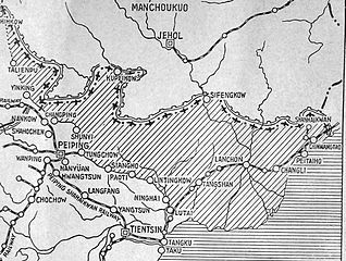
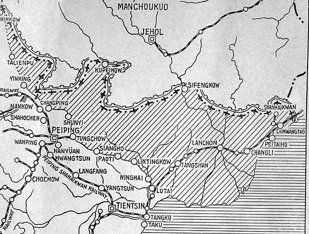
English: The shaded part of this map shows the areas demilitarized by the Tanggu Truce. Note also that the remainder of the Hebei Province, including Beijing and Tianjin, would also be demilitarized of Nationalist forces under the terms of the He-Umezu Agreement, but independent warlords like Song Zheyuan continued to operate there. |
| Fecha | |
| Fuente | a pamphlet called "Sino-Japanese Conflict Elucidated" |
| Autor | Canadian Japanese Association |
Licencia
[editar]
This Canadian work, of which the author or authors are unknown, is in the public domain in Canada because:
(R.S.C., 2020, c. C-42, s. 6.1, R.S.C., 1993, c. C-42, s. 6.1) |
 | |
|
|
Historial del archivo
Haz clic sobre una fecha y hora para ver el archivo tal como apareció en ese momento.
| Fecha y hora | Miniatura | Dimensiones | Usuario | Comentario | |
|---|---|---|---|---|---|
| actual | 22:47 18 oct 2012 | | 1985 × 1500 (403 kB) | CurtisNaito (discusión | contribs.) | User created page with UploadWizard |
No puedes sobrescribir este archivo.
Usos del archivo
No hay páginas que enlacen a este archivo.
Uso global del archivo
Las wikis siguientes utilizan este archivo:
- Uso en ar.wikipedia.org
- Uso en en.wikipedia.org
- Uso en es.wikipedia.org
- Uso en fa.wikipedia.org
- Uso en fr.wikipedia.org
- Uso en it.wikipedia.org
- Uso en ko.wikipedia.org
- Uso en lv.wikipedia.org
- Uso en nl.wikipedia.org
- Uso en pt.wikipedia.org
- Uso en ru.wikipedia.org
- Uso en uk.wikipedia.org