File:Temburong mukims.png
跳至導覽
跳至搜尋
無更高解析度可提供。
Temburong_mukims.png (696 × 565 像素,檔案大小:57 KB,MIME 類型:image/png)
說明
說明
添加單行說明來描述出檔案所代表的內容
摘要
[編輯]
| 描述 |
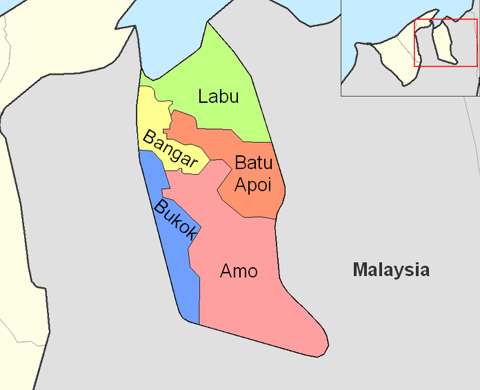
English: Map of the mukims (subdivisions) of the Temburong District of Brunei, in the northwest of the island of Borneo.
Created by Rarelibra 21:37, 11 September 2006 (UTC) for public domain use, using MapInfo Professional v8.5 and various mapping resources. |
| 日期 | 2006年九月11日 (原始上傳日期) |
| 來源 | Transferred from en.wikipedia to Commons by Xfigpower. |
| 作者 | 英文維基百科的Rarelibra |
授權條款
[編輯]
| 此作品已由其作者,英文維基百科的Rarelibra,釋出至公有領域。此授權條款在全世界均適用。 這可能在某些國家不合法,如果是的話: Rarelibra授予任何人有權利使用此作品於任何用途,除受法律約束外,不受任何限制。 |
原始上傳日誌
[編輯]
The original description page was here. All following user names refer to en.wikipedia.
- 2006-09-11 21:37 Rarelibra 1056×816×8 (19331 bytes) Map of the mukims of Temburong district of Brunei. Created by ~~~~ for public domain use, using MapInfo Professional v8.5 and various mapping resources.
檔案歷史
點選日期/時間以檢視該時間的檔案版本。
| 日期/時間 | 縮圖 | 尺寸 | 用戶 | 備註 | |
|---|---|---|---|---|---|
| 目前 | 2011年2月27日 (日) 08:59 | | 696 × 565(57 KB) | Naturals(對話 | 貢獻) | color + change size and type of font |
| 2008年7月3日 (四) 13:27 |  | 1,056 × 816(19 KB) | Xfigpower(對話 | 貢獻) | {{Information |Description={{en|Map of the mukims of Temburong district of Brunei. Created by Rarelibra 21:37, 11 September 2006 (UTC) for public domain use, using MapInfo Professional v8.5 and various mapping resources.}} |Source=T |
無法覆蓋此檔案。
檔案用途
下列4個頁面有用到此檔案:
全域檔案使用狀況
以下其他 wiki 使用了這個檔案:
- de.wikipedia.org 的使用狀況
- en.wikipedia.org 的使用狀況
- es.wikipedia.org 的使用狀況
- fa.wikipedia.org 的使用狀況
- frr.wikipedia.org 的使用狀況
- fr.wikipedia.org 的使用狀況
- hu.wikipedia.org 的使用狀況
- id.wikipedia.org 的使用狀況
- it.wikipedia.org 的使用狀況
- ja.wikipedia.org 的使用狀況
- ko.wikipedia.org 的使用狀況
- lt.wikipedia.org 的使用狀況
- nl.wikipedia.org 的使用狀況
- no.wikipedia.org 的使用狀況
- pl.wikipedia.org 的使用狀況
檢視此檔案的更多全域使用狀況。