File:Terrain rendering.jpg
跳至導覽
跳至搜尋
無更高解析度可提供。
Terrain_rendering.jpg (500 × 500 像素,檔案大小:36 KB,MIME 類型:image/jpeg)
說明
說明
添加單行說明來描述出檔案所代表的內容
摘要
[編輯]
| 描述 |
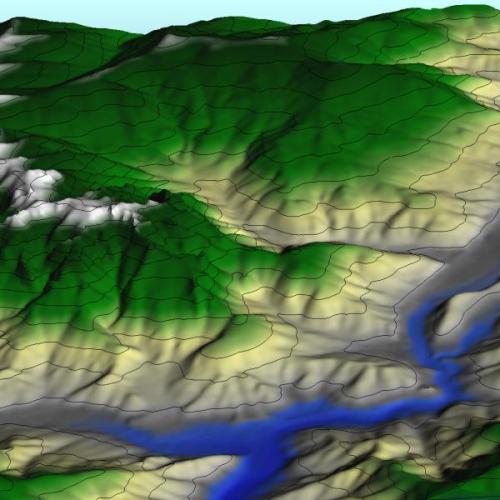
English: Terrain rendering
VisIt can read several file formats common in the field of Geographic Information Systems (GIS), allowing you to plot raster data such as terrain data in your visualizations. The featured image shows a plot of a DEM dataset containing mountainous areas near Dunsmuir, CA. Elevation lines are added to the plot to help delineate changes in elevation. The DEM dataset used to create the featured image was obtained from the USGS. |
| 日期 | Updated: November 8, 2007 |
| 來源 | Visualizations that have been created with VisIt. at wci.llnl.gov |
| 作者 | UCRL |
授權條款
[編輯]
此作品在美國屬於公有領域,因為其是由美國政府的官員或僱員,基於其個人公務目的製作的作品,參考美國法典第17篇第1章第105條。
注意︰本模板僅適用於美國聯邦政府的原創作品,不適用於任何美國州、屬地、聯邦個體、縣、市或任何次級政府的作品。本模板也不適用於1978年以後由美國郵政署出版的郵票圖案(參看美國版權局實踐綱領第313.6(C)(1)條)。也不適用於部分美國硬幣;參看美國鑄幣局使用條款。 |
 | |
| 此作品無已知的著作權限制,亦不受所有相關和鄰接的權利限制。 | ||
檔案歷史
點選日期/時間以檢視該時間的檔案版本。
| 日期/時間 | 縮圖 | 尺寸 | 使用者 | 備註 | |
|---|---|---|---|---|---|
| 目前 | 2008年7月11日 (五) 00:13 | | 500 × 500(36 KB) | Mdd(留言 | 貢獻) | {{Information |Description={{en|1=Terrain rendering VisIt can read several file formats common in the field of Geographic Information Systems (GIS), allowing you to plot raster data such as terrain data in your visualizations. The featured image shows a |
無法覆蓋此檔案。
檔案用途
沒有使用此檔案的頁面。
全域檔案使用狀況
以下其他 wiki 使用了這個檔案:
- en.wikipedia.org 的使用狀況
- et.wikipedia.org 的使用狀況
- it.wikipedia.org 的使用狀況
- ru.wikipedia.org 的使用狀況
- zh.wikipedia.org 的使用狀況