File:Territory Of The German Military Commander In Serbia 1941-44.png
跳转到导航
跳转到搜索
本预览的尺寸:474 × 599像素。 其他分辨率:190 × 240像素 | 500 × 632像素。
原始文件 (500 × 632像素,文件大小:99 KB,MIME类型:image/png)
说明
说明
添加一行文字以描述该文件所表现的内容
摘要
[编辑]
| 描述 |
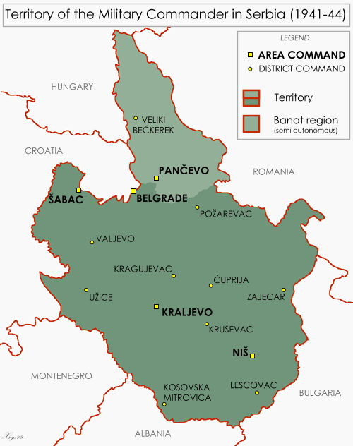
English: Map of the Territory of the German Military Commander in Serbia. Showing area and district commands and the Banat autonomous region. |
| 日期 | |
| 来源 | 自己的作品, drawn from Serbia - June 1944 1:2M MDR Misc 8380, Survey Directorate, Middle East (1944) and Volkstumkarte Jugoslawien 1:200k, Wilfried Krallert, Publikationsstelle Wien (1941) |
| 作者 | XrysD |
许可协议
[编辑]
我,本作品著作权人,特此采用以下许可协议发表本作品:
本文件采用知识共享署名-相同方式共享 3.0 未本地化版本许可协议授权。
- 您可以自由地:
- 共享 – 复制、发行并传播本作品
- 修改 – 改编作品
- 惟须遵守下列条件:
- 署名 – 您必须对作品进行署名,提供授权条款的链接,并说明是否对原始内容进行了更改。您可以用任何合理的方式来署名,但不得以任何方式表明许可人认可您或您的使用。
- 相同方式共享 – 如果您再混合、转换或者基于本作品进行创作,您必须以与原先许可协议相同或相兼容的许可协议分发您贡献的作品。
文件历史
点击某个日期/时间查看对应时刻的文件。
| 日期/时间 | 缩略图 | 大小 | 用户 | 备注 | |
|---|---|---|---|---|---|
| 当前 | 2012年5月10日 (四) 13:47 | | 500 × 632(99 KB) | XrysD(留言 | 贡献) | Removed map frame as infobox border now acts as frame |
| 2012年5月9日 (三) 19:59 |  | 500 × 632(94 KB) | XrysD(留言 | 贡献) | Border colour now AAAAAA to fit with Infobox template | |
| 2012年5月9日 (三) 19:29 |  | 500 × 632(94 KB) | XrysD(留言 | 贡献) | Reverted to version as of 19:19, 9 May 2012 | |
| 2012年5月9日 (三) 19:22 |  | 500 × 632(117 KB) | XrysD(留言 | 贡献) | Border colour now matches AAAAAA of Infobox style | |
| 2012年5月9日 (三) 19:19 |  | 500 × 632(94 KB) | XrysD(留言 | 贡献) | Border colour wrong | |
| 2012年5月9日 (三) 19:14 |  | 500 × 632(94 KB) | XrysD(留言 | 贡献) | Added border | |
| 2012年5月9日 (三) 19:11 |  | 500 × 632(94 KB) | XrysD(留言 | 贡献) | Added border | |
| 2012年5月9日 (三) 18:55 |  | 500 × 632(93 KB) | XrysD(留言 | 贡献) | Changed map background to F9F9F9 to harmonise with Infobox background. Added Pancevo area command and Veliki Beckerek district command. | |
| 2012年5月7日 (一) 16:05 |  | 500 × 632(93 KB) | XrysD(留言 | 贡献) | Corrected map title. | |
| 2012年5月7日 (一) 15:59 |  | 500 × 632(93 KB) | XrysD(留言 | 贡献) |
您不可以覆盖此文件。
文件用途
以下2个页面使用本文件:
全域文件用途
以下其他wiki使用此文件:
- ar.wikipedia.org上的用途
- bs.wikipedia.org上的用途
- de.wikipedia.org上的用途
- en.wikipedia.org上的用途
- es.wikipedia.org上的用途
- et.wikipedia.org上的用途
- fa.wikipedia.org上的用途
- fr.wikipedia.org上的用途
- id.wikipedia.org上的用途
- it.wikipedia.org上的用途
- ms.wikipedia.org上的用途
- pt.wikipedia.org上的用途
- ro.wikipedia.org上的用途
- sq.wikipedia.org上的用途
- sr.wikipedia.org上的用途
- th.wikipedia.org上的用途
- uk.wikipedia.org上的用途
- uz.wikipedia.org上的用途
- www.wikidata.org上的用途
- zh.wikipedia.org上的用途